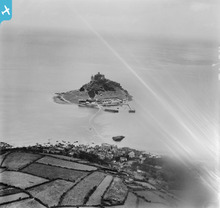
EPW021761 ENGLAND (1928). St Michael's Mount, the harbour and part of the causeway, St Michael's Mount, from the north, 1928
© Copyright OpenStreetMap contributors and licensed by the OpenStreetMap Foundation. 2025. Cartography is licensed as CC BY-SA.
Details
| Title | [EPW021761] St Michael's Mount, the harbour and part of the causeway, St Michael's Mount, from the north, 1928 |
| Reference | EPW021761 |
| Date | 24-June-1928 |
| Link | |
| Place name | ST MICHAEL'S MOUNT |
| Parish | ST. MICHAEL'S MOUNT |
| District | |
| Country | ENGLAND |
| Easting / Northing | 151690, 30506 |
| Longitude / Latitude | -5.4742765590466, 50.121967749492 |
| National Grid Reference | SW517305 |
Pins
User Comment Contributions
 Brian Wilkinson |
Friday 25th of May 2012 04:02:41 PM |


