
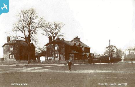
EPW021872 ENGLAND (1928). Oxhey Road and environs, Oxhey, 1928

© Copyright OpenStreetMap contributors and licensed by the OpenStreetMap Foundation. 2025. Cartography is licensed as CC BY-SA.
Nearby Images (2)
EPW021872

EPW021873

Details
| Title | [EPW021872] Oxhey Road and environs, Oxhey, 1928 |
| Reference | EPW021872 |
| Date | July-1928 |
| Link | |
| Place name | OXHEY |
| Parish | |
| District | |
| Country | ENGLAND |
| Easting / Northing | 511714, 194658 |
| Longitude / Latitude | -0.38545888005983, 51.639149684107 |
| National Grid Reference | TQ117947 |
Pins
 ordinarybloke |
Thursday 5th of September 2024 10:57:33 PM | |
ordinarybloke |
Thursday 5th of September 2024 05:20:36 PM | |
ordinarybloke |
Thursday 30th of May 2024 10:22:55 PM | |
ordinarybloke |
Saturday 14th of January 2023 04:32:10 PM | |
 |
ordinarybloke |
Thursday 1st of December 2022 10:44:15 AM |
ordinarybloke |
Wednesday 6th of October 2021 03:59:31 PM | |
ordinarybloke |
Wednesday 6th of October 2021 03:59:09 PM | |
 |
ordinarybloke |
Friday 23rd of April 2021 08:04:58 AM |
ordinarybloke |
Wednesday 7th of October 2020 09:29:30 AM | |
 |
ordinarybloke |
Wednesday 7th of October 2020 07:25:13 AM |
 |
ordinarybloke |
Wednesday 7th of October 2020 07:24:05 AM |
 |
ordinarybloke |
Sunday 16th of August 2020 09:20:37 PM |
ordinarybloke |
Monday 13th of April 2020 11:56:39 PM | |
ordinarybloke |
Friday 23rd of August 2019 09:58:56 PM | |
ordinarybloke |
Tuesday 16th of July 2019 09:39:55 AM | |
Here's the 302 on that very corner. I recall a red phonebox here somewhere. |
ordinarybloke |
Wednesday 10th of April 2013 01:30:18 PM |
I can remember this bus stop when the fountain was there. I lived in Carpenders Avenue, and used the 302 bus to go to Kings Langley. |
Arthur Hall |
Wednesday 14th of January 2015 06:13:52 PM |
ordinarybloke |
Tuesday 16th of July 2019 09:30:08 AM | |
ordinarybloke |
Monday 4th of March 2019 10:23:12 AM | |
ordinarybloke |
Monday 4th of March 2019 10:21:10 AM | |
ordinarybloke |
Wednesday 6th of February 2019 10:13:04 PM | |
ordinarybloke |
Saturday 17th of November 2018 09:54:17 PM | |
ordinarybloke |
Tuesday 9th of October 2018 09:20:56 AM | |
 |
ordinarybloke |
Tuesday 9th of October 2018 09:19:20 AM |
ordinarybloke |
Tuesday 9th of October 2018 09:06:14 AM | |
 |
ordinarybloke |
Thursday 19th of April 2018 04:18:47 PM |
ordinarybloke |
Thursday 1st of March 2018 01:57:40 PM | |
 |
ordinarybloke |
Tuesday 27th of June 2017 11:06:58 AM |
ordinarybloke |
Saturday 11th of March 2017 09:03:09 AM | |
ordinarybloke |
Saturday 11th of March 2017 08:59:18 AM | |
 |
ordinarybloke |
Tuesday 1st of March 2016 11:03:00 AM |
ordinarybloke |
Monday 29th of February 2016 10:02:32 AM | |
ordinarybloke |
Sunday 9th of November 2014 02:11:47 AM | |
Following the road towards the right turn, in the corner of that bend is a Public Footpath which runs parallel to the railway, passing what was a cattle bridge, from which you could see the Railway water troughs, from which steam engines replenished their water tanks. The footpath continued, passing through two cattle tunnels, where you could join Oxhey Golf Course, and then terminated at Carpenders Park, joining a road, which still exists, leading to Alva Way, Penrose Avenue, and Carpenders Avenue near the shops. |
Arthur Hall |
Wednesday 14th of January 2015 06:32:05 PM |
ordinarybloke |
Wednesday 7th of May 2014 08:05:49 PM | |
ordinarybloke |
Monday 6th of January 2014 04:14:29 PM | |
 John Swain |
Sunday 4th of August 2013 01:25:19 PM | |
ordinarybloke |
Wednesday 10th of April 2013 01:25:13 PM | |
ordinarybloke |
Saturday 6th of April 2013 06:22:20 PM | |
ordinarybloke |
Saturday 6th of April 2013 06:19:46 PM | |
ordinarybloke |
Saturday 6th of April 2013 06:18:18 PM | |
up above |
Tuesday 18th of December 2012 06:31:34 PM | |
John Swain |
Wednesday 25th of July 2012 11:09:19 AM | |
John Swain |
Wednesday 25th of July 2012 11:07:54 AM | |
John Swain |
Wednesday 25th of July 2012 11:06:43 AM | |
John Swain |
Wednesday 25th of July 2012 10:59:51 AM | |
John Swain |
Wednesday 25th of July 2012 10:58:42 AM | |
John Swain |
Wednesday 25th of July 2012 10:56:58 AM | |
John Swain |
Wednesday 25th of July 2012 08:36:41 AM | |
Others pics show Elm Ave, sorry not here, You have indicated 50 odd yards down from 'Load of Gay' |
ordinarybloke |
Saturday 6th of April 2013 06:16:31 PM |
John Swain |
Wednesday 25th of July 2012 08:35:14 AM | |
John Swain |
Wednesday 25th of July 2012 08:33:20 AM | |
DLJ |
Wednesday 27th of June 2012 01:23:14 AM | |
 Ian Jones |
Tuesday 26th of June 2012 12:22:32 AM | |
Yes that's what I've been told those reservoirs were for. One of my neighbours remembers standing on the bridge and watching ?Royal Scot going down the line. |
Whittocks |
Sunday 1st of July 2012 01:03:36 PM |
Three water troughs were laid in 1864 and remained in place until June 29th, 1965. The reservoir site was sold to an education authority. Source: Harrow to Watford, Vic Mitchell & Keith Smith, Middleton Press, 2003. |
John Swain |
Wednesday 25th of July 2012 11:20:58 AM |
These stand out very well in all the other pics of Watford. Seen in the distance, I've use them as a visual reference to identify many other points in Watford, Bushey & Oxhey pics. |
ordinarybloke |
Wednesday 19th of March 2014 09:50:33 AM |


User Comment Contributions
 Another sharp and detailed image which, again, has attracted plenty of comment from viewers, including the not-so-ordinary bloke from Bushey Meads! I hope he, among others, will consider joining this group in addition to those they are already members of. There seems to be a lot of interest shown in the photographs of the SW Herts area, which, in common with many parts of SE England, has undergone considerable change in my lifetime of almost 70 years! |
John Swain |
Sunday 4th of August 2013 01:30:27 PM |
i love to see the orginal wiggenhall and that the tress on the heath are so young |
This is six |
Tuesday 15th of January 2013 03:10:19 PM |
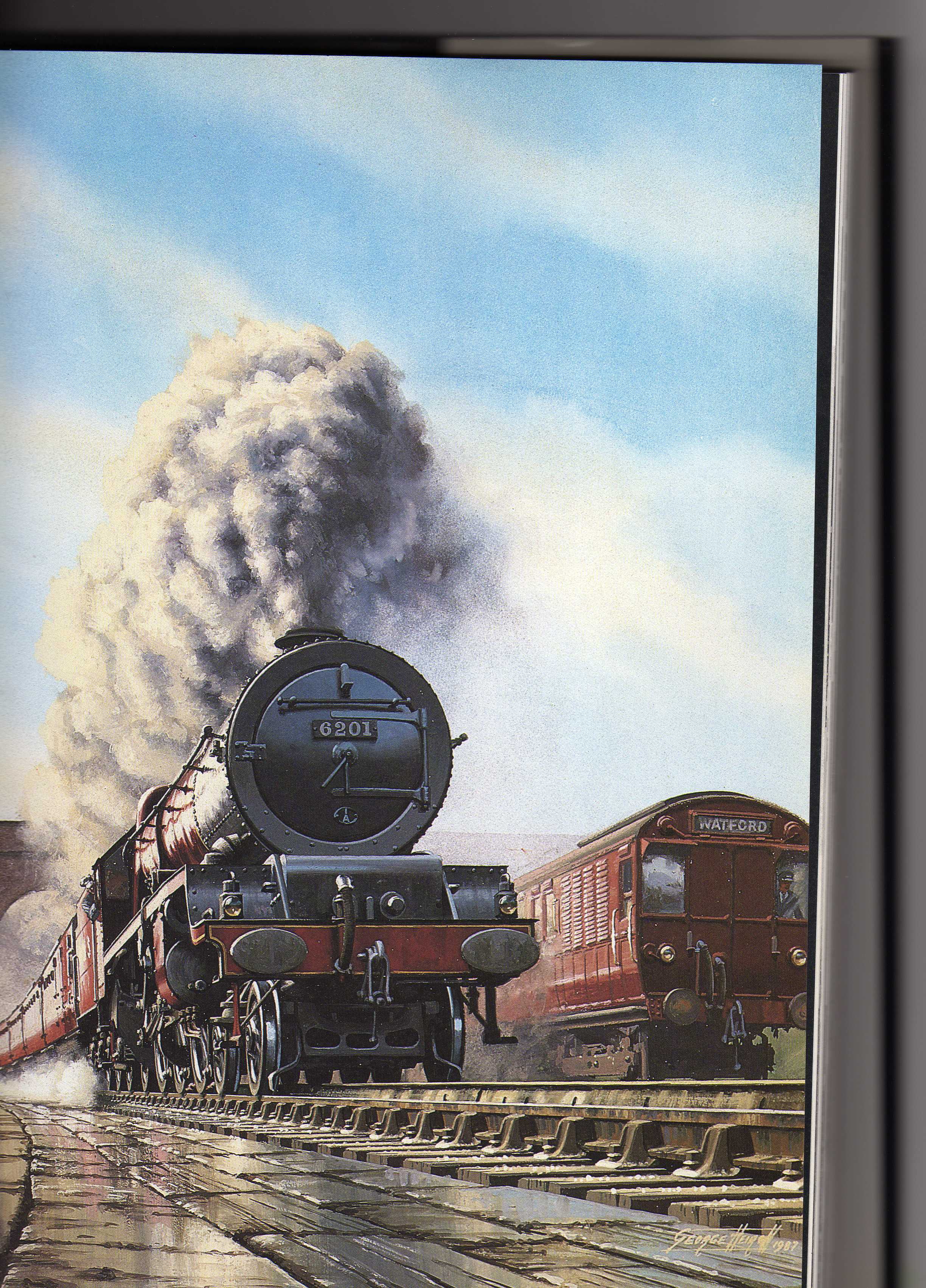 The Royal Scot express from Euston to Glasgow passes over Bushey Troughs hauled by Stanier 4-6-2 Pacific Class No. 6201 "Princess Elizabeth", which had charge of the prestigious service on the west coast route between 1933 and 1937. On the right a Euston-Watford electric train (Oerlikon in dull brown livery) is being overtaken, with the four-arch overbridge at Oxhey Road in the background. This image was taken from a painting by George Heiron in 1987, which is featured in "LMS 150", The London Midland & Scottish Railway: A century and a half of progress, by Patrick Whitehouse & David St.John Thomas, Greenwich Editions, London, 1995. |
John Swain |
Wednesday 8th of August 2012 10:33:03 PM |
Magic! |
Whittocks |
Wednesday 8th of August 2012 10:33:03 PM |
 The Royal Scot express from Euston to Glasgow passes over Bushey Troughs hauled by Stanier 4-6-2 Pacific Class No. 6201 "Princess Elizabeth", which had charge of the prestigious service on the west coast route between 1933 and 1937. On the right a Euston-Watford electric train (Oerlikon in dull brown livery) is being overtaken, with the four-arch overbridge at Oxhey Road in the background. This image was taken from a painting by George Heiron in 1987, which is featured in "LMS 150", The London Midland & Scottish Railway: A century and a half of progress, by Patrick Whitehouse & David St.John Thomas, Greenwich Editions, London, 1995. |
John Swain |
Friday 27th of July 2012 11:09:41 AM |
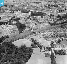
The principal feature in this image is the London Midland & Scottish Railway line, which was constructed in 1837 as the main line between the capital and Birmingham. Before the Big Four Grouping of January 1st, 1923, this was the London & North Western Railway. It was not permitted to run through Cassiobury, along the route of the Grand Union Canal, by the Earl of Essex, in early Victorian Britain, so a wide sweeping curve was adopted around the eastern flanks of the expanding town of Watford, from Bushey Arches to Watford Station on St.Albans Road (later Watford Junction). The gravel and chalk extracted from the deep cutting observed on the photograph was used as an embankment across the Colne valley to the north-east. Sherwoods Wood occupies the left foreground. |
John Swain |
Wednesday 25th of July 2012 10:55:23 AM |
The deep cutting at Bushey on the E.C.M.L. with the water troughs just visible n the right of the main line. |
Puffpuffbuff |
Thursday 28th of June 2012 07:54:19 AM |