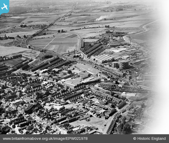
EPW021978 ENGLAND (1928). J & E Hall Engineering Works, Dartford, from the south-east, 1928
© Copyright OpenStreetMap contributors and licensed by the OpenStreetMap Foundation. 2025. Cartography is licensed as CC BY-SA.
Nearby Images (23)
Details
| Title | [EPW021978] J & E Hall Engineering Works, Dartford, from the south-east, 1928 |
| Reference | EPW021978 |
| Date | July-1928 |
| Link | |
| Place name | DARTFORD |
| Parish | |
| District | |
| Country | ENGLAND |
| Easting / Northing | 554189, 174267 |
| Longitude / Latitude | 0.21904533314594, 51.445882646575 |
| National Grid Reference | TQ542743 |
Pins
 John Wass |
Sunday 3rd of May 2020 02:55:17 PM |


![[EPW021978] J & E Hall Engineering Works, Dartford, from the south-east, 1928](http://britainfromabove.org.uk/sites/all/libraries/aerofilms-images/public/100x100/EPW/021/EPW021978.jpg)
![[EPW061008] The town, Dartford, 1939](http://britainfromabove.org.uk/sites/all/libraries/aerofilms-images/public/100x100/EPW/061/EPW061008.jpg)
![[EPW021976] J & E Hall Engineering Works, Dartford, 1928](http://britainfromabove.org.uk/sites/all/libraries/aerofilms-images/public/100x100/EPW/021/EPW021976.jpg)
![[EPW061007] The town, Dartford, 1939](http://britainfromabove.org.uk/sites/all/libraries/aerofilms-images/public/100x100/EPW/061/EPW061007.jpg)
![[EPW057058] The town centre, Dartford, 1938. This image has been affected by flare.](http://britainfromabove.org.uk/sites/all/libraries/aerofilms-images/public/100x100/EPW/057/EPW057058.jpg)
![[EPW010895] Hall's Engineering Works and surroundings, Dartford, 1924](http://britainfromabove.org.uk/sites/all/libraries/aerofilms-images/public/100x100/EPW/010/EPW010895.jpg)
![[EPW061014] The town centre and Dartford Fresh Marshes, Dartford, from the south, 1939](http://britainfromabove.org.uk/sites/all/libraries/aerofilms-images/public/100x100/EPW/061/EPW061014.jpg)
![[EAW048627] Lowfield Street and the town centre, Dartford, 1953](http://britainfromabove.org.uk/sites/all/libraries/aerofilms-images/public/100x100/EAW/048/EAW048627.jpg)
![[EPW028231] The junction of Spital Street, Hythe Street and the High Street, Dartford, 1929](http://britainfromabove.org.uk/sites/all/libraries/aerofilms-images/public/100x100/EPW/028/EPW028231.jpg)
![[EPW057057] The town centre, Dartford, from the north, 1938](http://britainfromabove.org.uk/sites/all/libraries/aerofilms-images/public/100x100/EPW/057/EPW057057.jpg)
![[EPW010899] The town centre, Dartford, 1924](http://britainfromabove.org.uk/sites/all/libraries/aerofilms-images/public/100x100/EPW/010/EPW010899.jpg)
![[EPW021979] J & E Hall Engineering Works, Dartford, 1928](http://britainfromabove.org.uk/sites/all/libraries/aerofilms-images/public/100x100/EPW/021/EPW021979.jpg)
![[EAW001394] Burroughs, Wellcome and Co Chemical Works and environs, Dartford, from the south, 1946](http://britainfromabove.org.uk/sites/all/libraries/aerofilms-images/public/100x100/EAW/001/EAW001394.jpg)
![[EAW048625] High Street, Spital Street and the town, Dartford, from the east, 1953](http://britainfromabove.org.uk/sites/all/libraries/aerofilms-images/public/100x100/EAW/048/EAW048625.jpg)
![[EPW021977] J & E Hall Engineering Works, Dartford, 1928](http://britainfromabove.org.uk/sites/all/libraries/aerofilms-images/public/100x100/EPW/021/EPW021977.jpg)
![[EPW061012] Kent Road and environs, Dartford, 1939](http://britainfromabove.org.uk/sites/all/libraries/aerofilms-images/public/100x100/EPW/061/EPW061012.jpg)
![[EPW028229] Spital Street and environs, Dartford, 1929](http://britainfromabove.org.uk/sites/all/libraries/aerofilms-images/public/100x100/EPW/028/EPW028229.jpg)
![[EPW021980] J & E Hall Engineering Works and environs, Dartford, 1928. This image has been produced from a print.](http://britainfromabove.org.uk/sites/all/libraries/aerofilms-images/public/100x100/EPW/021/EPW021980.jpg)
![[EPW010897] Daren Flour Mills and Burroughs Wellcome Chemical Works, Dartford, 1924](http://britainfromabove.org.uk/sites/all/libraries/aerofilms-images/public/100x100/EPW/010/EPW010897.jpg)
![[EPW006256] Burrough Wellcome Chemical Works, Dartford, 1921](http://britainfromabove.org.uk/sites/all/libraries/aerofilms-images/public/100x100/EPW/006/EPW006256.jpg)
![[EPW021982] J & E Hall Engineering Works, Dartford, 1928. This image has been produced from a print.](http://britainfromabove.org.uk/sites/all/libraries/aerofilms-images/public/100x100/EPW/021/EPW021982.jpg)
![[EAW001403] Burroughs, Wellcome and Co Chemical Works and environs, Dartford, from the south, 1946](http://britainfromabove.org.uk/sites/all/libraries/aerofilms-images/public/100x100/EAW/001/EAW001403.jpg)
![[EPW057059] Spital Street and environs, Dartford, 1938](http://britainfromabove.org.uk/sites/all/libraries/aerofilms-images/public/100x100/EPW/057/EPW057059.jpg)