
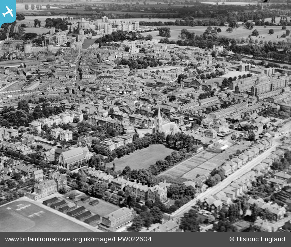
EPW022604 ENGLAND (1928). The town centre, Windsor, 1928
© Copyright OpenStreetMap contributors and licensed by the OpenStreetMap Foundation. 2025. Cartography is licensed as CC BY-SA.
Nearby Images (6)
EPW022604

EPW037034

EPW022610

EAW052998

EPW001596

EPW056588

Details
| Title | [EPW022604] The town centre, Windsor, 1928 |
| Reference | EPW022604 |
| Date | 11-August-1928 |
| Link | |
| Place name | WINDSOR |
| Parish | |
| District | |
| Country | ENGLAND |
| Easting / Northing | 496398, 176476 |
| Longitude / Latitude | -0.61172324878286, 51.478532165675 |
| National Grid Reference | SU964765 |
Pins
 |
 Thamesweb |
Wednesday 11th of January 2017 11:56:38 AM |
Thamesweb |
Wednesday 11th of January 2017 11:52:47 AM | |
Thamesweb |
Wednesday 11th of January 2017 11:52:00 AM | |
Thamesweb |
Wednesday 11th of January 2017 11:47:50 AM | |
Ellensdottir |
Saturday 9th of November 2013 09:03:49 PM | |
Ellensdottir |
Saturday 9th of November 2013 08:58:54 PM | |
Not Combermere Barracks as that was along St Leonards Road, south of this area. These are the Goodhart Gates donated to the school in the 1920s. But it is true that the military used the old school buildings, especially the classroom block in the 1950s and early 60s. |
Thamesweb |
Friday 20th of December 2013 03:56:20 PM |
Ellensdottir |
Saturday 9th of November 2013 08:58:08 PM | |
Ellensdottir |
Saturday 9th of November 2013 08:54:35 PM | |
Ellensdottir |
Saturday 9th of November 2013 08:53:55 PM | |
Ellensdottir |
Saturday 9th of November 2013 08:41:16 PM | |
Ellensdottir |
Saturday 9th of November 2013 08:38:09 PM | |
Ellensdottir |
Saturday 9th of November 2013 08:38:07 PM | |
Ellensdottir |
Saturday 9th of November 2013 08:28:51 PM | |
St. John the Baptist Church, Parish Church |
Ellensdottir |
Saturday 9th of November 2013 08:33:49 PM |
Ellensdottir |
Saturday 9th of November 2013 08:26:36 PM | |
Bachelors Acre :) |
Thamesweb |
Thursday 31st of July 2014 09:11:44 AM |
Norman W |
Sunday 21st of October 2012 04:47:24 PM | |
Eton please :) |
Thamesweb |
Wednesday 30th of January 2013 04:13:24 PM |
Thamesweb |
Saturday 1st of September 2012 06:54:34 PM | |
Thamesweb |
Saturday 1st of September 2012 06:53:38 PM | |
dave43 |
Monday 9th of July 2012 01:21:06 PM |
User Comment Contributions
 Windsor and Eton Central Railway Station |
 Alan McFaden |
Saturday 8th of November 2014 10:49:40 AM |
 Windsor Castle |
Alan McFaden |
Saturday 8th of November 2014 10:43:22 AM |
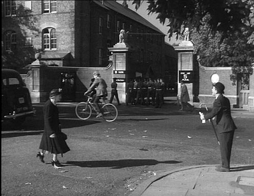 Here is a view of the Goodhart Gates from a Norman Wisdom film, Follow a Star |
Thamesweb |
Friday 20th of December 2013 03:58:52 PM |
Bottom left, are the grounds of ISC (Imperial Service College), with Camperdown House (still in existence as of 2012) by the corner of the playing fields. Adjacent are some white marks in the grass which could well be the location of cricket 'nets'. Being August these would have been packed away in the school holidays. The huts, at least six, are further to the right between Camperdown and Alexander Houses. The latter was demolished in the 1970s. Eleven years after this photo was taken this area was developed with the construction of Kipling Building, 1939, its driveway cutting through the area of huts from Alma Road. The college soon moved to Hertford to join with the United Services College, a move forced by the war. Web history is here http://www.thamesweb.co.uk/windsor/windsorhistory/isc.html Lower centre, below Trinity Church, is the area known as the Prairie, the sports field for Windsor County Boys School in 1928. This area became East Berkshire College in about 1960, itself demolished to make way for houses in 2010. On the east side, beside the church and hidden by trees, is Church House originally built for Rev Hawtrey, and subsequently used by the school. The school was established in 1908 and the school rooms can be seen across the small square to the right of the church. Other points of interest are the Roman Catholic Church in Alma Road, immediately above Camperdown House, the trees far left centre surround the private gardens of Clarence Crescent and bisecting the lower, right hand corner is St Marks Road. There is much more about Windsor here: http://theroyalwindsorforum.yuku.com/ |
Thamesweb |
Tuesday 26th of June 2012 12:20:43 AM |