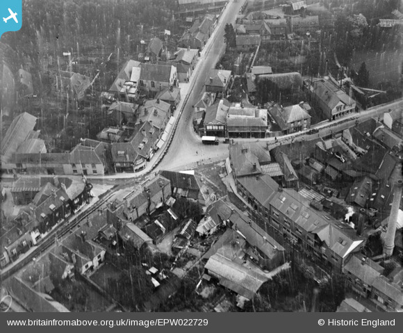
EPW022729 ENGLAND (1928). The town centre, Whitchurch, 1928
© Copyright OpenStreetMap contributors and licensed by the OpenStreetMap Foundation. 2025. Cartography is licensed as CC BY-SA.
Nearby Images (6)
Details
| Title | [EPW022729] The town centre, Whitchurch, 1928 |
| Reference | EPW022729 |
| Date | August-1928 |
| Link | |
| Place name | WHITCHURCH |
| Parish | WHITCHURCH |
| District | |
| Country | ENGLAND |
| Easting / Northing | 446241, 148064 |
| Longitude / Latitude | -1.3376735503919, 51.229374178825 |
| National Grid Reference | SU462481 |
Pins
Be the first to add a comment to this image!


![[EPW022729] The town centre, Whitchurch, 1928](http://britainfromabove.org.uk/sites/all/libraries/aerofilms-images/public/100x100/EPW/022/EPW022729.jpg)
![[EPW022730] The town centre, Whitchurch, 1928](http://britainfromabove.org.uk/sites/all/libraries/aerofilms-images/public/100x100/EPW/022/EPW022730.jpg)
![[EPW022731] The town centre, Whitchurch, 1928](http://britainfromabove.org.uk/sites/all/libraries/aerofilms-images/public/100x100/EPW/022/EPW022731.jpg)
![[EPW033346] The town and surrounding countryside, Whitchurch, 1930](http://britainfromabove.org.uk/sites/all/libraries/aerofilms-images/public/100x100/EPW/033/EPW033346.jpg)
![[EPW022732] The town, Whitchurch, from the south-east, 1928](http://britainfromabove.org.uk/sites/all/libraries/aerofilms-images/public/100x100/EPW/022/EPW022732.jpg)
![[EPW033348] The town centre and environs, Whitchurch, 1930. This image has been affected by flare.](http://britainfromabove.org.uk/sites/all/libraries/aerofilms-images/public/100x100/EPW/033/EPW033348.jpg)