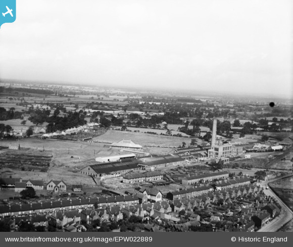
EPW022889 ENGLAND (1928). Goodyear Tyre and Rubber Works, Bushbury, from the south-east, 1928
© Copyright OpenStreetMap contributors and licensed by the OpenStreetMap Foundation. 2025. Cartography is licensed as CC BY-SA.
Nearby Images (45)
Details
| Title | [EPW022889] Goodyear Tyre and Rubber Works, Bushbury, from the south-east, 1928 |
| Reference | EPW022889 |
| Date | August-1928 |
| Link | |
| Place name | BUSHBURY |
| Parish | |
| District | |
| Country | ENGLAND |
| Easting / Northing | 391517, 301180 |
| Longitude / Latitude | -2.1252841012492, 52.607980205902 |
| National Grid Reference | SJ915012 |
Pins
 Elston |
Monday 25th of August 2014 09:29:40 AM |


![[EPW022889] Goodyear Tyre and Rubber Works, Bushbury, from the south-east, 1928](http://britainfromabove.org.uk/sites/all/libraries/aerofilms-images/public/100x100/EPW/022/EPW022889.jpg)
![[EPW022890] Goodyear Tyre and Rubber Works, Bushbury, from the south-east, 1928](http://britainfromabove.org.uk/sites/all/libraries/aerofilms-images/public/100x100/EPW/022/EPW022890.jpg)
![[EPW022895] Goodyear Tyre and Rubber Works and environs, Bushbury, from the south-west, 1928](http://britainfromabove.org.uk/sites/all/libraries/aerofilms-images/public/100x100/EPW/022/EPW022895.jpg)
![[EPW021011] Goodyear Tyre and Rubber Factory, Bushbury, from the south-east, 1928](http://britainfromabove.org.uk/sites/all/libraries/aerofilms-images/public/100x100/EPW/021/EPW021011.jpg)
![[EPW028647] The Goodyear Tyre and Rubber Company, Bushbury, 1929](http://britainfromabove.org.uk/sites/all/libraries/aerofilms-images/public/100x100/EPW/028/EPW028647.jpg)
![[EPW019999] The Goodyear Tyre and Rubber Company, Bushbury, 1927](http://britainfromabove.org.uk/sites/all/libraries/aerofilms-images/public/100x100/EPW/019/EPW019999.jpg)
![[EPW028637] The Goodyear Tyre and Rubber Company, Bushbury, 1929](http://britainfromabove.org.uk/sites/all/libraries/aerofilms-images/public/100x100/EPW/028/EPW028637.jpg)
![[EPW028629] The Goodyear Tyre and Rubber Company, Bushbury, 1929](http://britainfromabove.org.uk/sites/all/libraries/aerofilms-images/public/100x100/EPW/028/EPW028629.jpg)
![[EPW028636] The Goodyear Tyre and Rubber Company, Bushbury, 1929](http://britainfromabove.org.uk/sites/all/libraries/aerofilms-images/public/100x100/EPW/028/EPW028636.jpg)
![[EPW045791] The Goodyear Tyre & Rubber Company and environs, Bushbury, 1934](http://britainfromabove.org.uk/sites/all/libraries/aerofilms-images/public/100x100/EPW/045/EPW045791.jpg)
![[EPW020005] The Goodyear Tyre and Rubber Company, Bushbury, from the south-east, 1927](http://britainfromabove.org.uk/sites/all/libraries/aerofilms-images/public/100x100/EPW/020/EPW020005.jpg)
![[EPW054857] The Goodyear Tyre and Rubber Co, Bushbury, 1937](http://britainfromabove.org.uk/sites/all/libraries/aerofilms-images/public/100x100/EPW/054/EPW054857.jpg)
![[EPW028634] The Goodyear Tyre and Rubber Company, Bushbury, 1929](http://britainfromabove.org.uk/sites/all/libraries/aerofilms-images/public/100x100/EPW/028/EPW028634.jpg)
![[EPW024556] The Goodyear Tyre and Rubber Co, Bushbury, 1928](http://britainfromabove.org.uk/sites/all/libraries/aerofilms-images/public/100x100/EPW/024/EPW024556.jpg)
![[EPW028630] The Goodyear Tyre and Rubber Company, Bushbury, 1929](http://britainfromabove.org.uk/sites/all/libraries/aerofilms-images/public/100x100/EPW/028/EPW028630.jpg)
![[EPW045785] The Goodyear Tyre & Rubber Company, Bushbury, 1934](http://britainfromabove.org.uk/sites/all/libraries/aerofilms-images/public/100x100/EPW/045/EPW045785.jpg)
![[EPW020007] The Goodyear Tyre and Rubber Company, Bushbury, 1927](http://britainfromabove.org.uk/sites/all/libraries/aerofilms-images/public/100x100/EPW/020/EPW020007.jpg)
![[EPW045788] The Goodyear Tyre & Rubber Company, Bushbury, 1934](http://britainfromabove.org.uk/sites/all/libraries/aerofilms-images/public/100x100/EPW/045/EPW045788.jpg)
![[EPW020001] The Goodyear Tyre and Rubber Company, Bushbury, 1927](http://britainfromabove.org.uk/sites/all/libraries/aerofilms-images/public/100x100/EPW/020/EPW020001.jpg)
![[EPW022894] Goodyear Tyre and Rubber Works and environs, Bushbury, from the south-east, 1928](http://britainfromabove.org.uk/sites/all/libraries/aerofilms-images/public/100x100/EPW/022/EPW022894.jpg)
![[EAW000791] The Goodyear Tyre and Rubber Company, Bushbury, 1946](http://britainfromabove.org.uk/sites/all/libraries/aerofilms-images/public/100x100/EAW/000/EAW000791.jpg)
![[EPW028638] The Goodyear Tyre and Rubber Company, Bushbury, 1929](http://britainfromabove.org.uk/sites/all/libraries/aerofilms-images/public/100x100/EPW/028/EPW028638.jpg)
![[EPW054858] The Goodyear Tyre and Rubber Co, Bushbury, from the south-west, 1937](http://britainfromabove.org.uk/sites/all/libraries/aerofilms-images/public/100x100/EPW/054/EPW054858.jpg)
![[EAW000789] The Goodyear Tyre and Rubber Company looking towards Low Hill, Bushbury, from the west, 1946](http://britainfromabove.org.uk/sites/all/libraries/aerofilms-images/public/100x100/EAW/000/EAW000789.jpg)
![[EPW020008] The Goodyear Tyre and Rubber Company, Bushbury, 1927](http://britainfromabove.org.uk/sites/all/libraries/aerofilms-images/public/100x100/EPW/020/EPW020008.jpg)
![[EPW024554] The Goodyear Tyre and Rubber Co, Bushbury, 1928](http://britainfromabove.org.uk/sites/all/libraries/aerofilms-images/public/100x100/EPW/024/EPW024554.jpg)
![[EAW000788] The Goodyear Tyre and Rubber Company looking towards Low Hill, Bushbury, from the west, 1946](http://britainfromabove.org.uk/sites/all/libraries/aerofilms-images/public/100x100/EAW/000/EAW000788.jpg)
![[EPW024552] The Goodyear Tyre and Rubber Co, Bushbury, 1928](http://britainfromabove.org.uk/sites/all/libraries/aerofilms-images/public/100x100/EPW/024/EPW024552.jpg)
![[EPW021010] Goodyear Tyre and Rubber Factory and Stafford Road, Bushbury, from the south, 1928](http://britainfromabove.org.uk/sites/all/libraries/aerofilms-images/public/100x100/EPW/021/EPW021010.jpg)
![[EPW020004] The Goodyear Tyre and Rubber Company, Bushbury, 1927](http://britainfromabove.org.uk/sites/all/libraries/aerofilms-images/public/100x100/EPW/020/EPW020004.jpg)
![[EPW020002] The Goodyear Tyre and Rubber Company, Bushbury, 1927](http://britainfromabove.org.uk/sites/all/libraries/aerofilms-images/public/100x100/EPW/020/EPW020002.jpg)
![[EPW024553] The Goodyear Tyre and Rubber Co, Bushbury, from the south-east, 1928](http://britainfromabove.org.uk/sites/all/libraries/aerofilms-images/public/100x100/EPW/024/EPW024553.jpg)
![[EPW045792] The Goodyear Tyre & Rubber Company, Bushbury, 1934](http://britainfromabove.org.uk/sites/all/libraries/aerofilms-images/public/100x100/EPW/045/EPW045792.jpg)
![[EPW054852] The Goodyear Tyre and Rubber Co, Bushbury, from the south-west, 1937](http://britainfromabove.org.uk/sites/all/libraries/aerofilms-images/public/100x100/EPW/054/EPW054852.jpg)
![[EPW028631] The Goodyear Tyre and Rubber Company, Bushbury, 1929](http://britainfromabove.org.uk/sites/all/libraries/aerofilms-images/public/100x100/EPW/028/EPW028631.jpg)
![[EPW020000] The Goodyear Tyre and Rubber Company, Bushbury, 1927](http://britainfromabove.org.uk/sites/all/libraries/aerofilms-images/public/100x100/EPW/020/EPW020000.jpg)
![[EPW045787] The Goodyear Tyre & Rubber Company and environs, Bushbury, 1934](http://britainfromabove.org.uk/sites/all/libraries/aerofilms-images/public/100x100/EPW/045/EPW045787.jpg)
![[EPW022892] Goodyear Tyre and Rubber Works, Bushbury, 1928](http://britainfromabove.org.uk/sites/all/libraries/aerofilms-images/public/100x100/EPW/022/EPW022892.jpg)
![[EPW020003] The Goodyear Tyre and Rubber Company, Bushbury, 1927](http://britainfromabove.org.uk/sites/all/libraries/aerofilms-images/public/100x100/EPW/020/EPW020003.jpg)
![[EPW045786] The Goodyear Tyre & Rubber Company, Bushbury, 1934](http://britainfromabove.org.uk/sites/all/libraries/aerofilms-images/public/100x100/EPW/045/EPW045786.jpg)
![[EAW000790] The Goodyear Tyre and Rubber Company, Bushbury, 1946](http://britainfromabove.org.uk/sites/all/libraries/aerofilms-images/public/100x100/EAW/000/EAW000790.jpg)
![[EAW000787] The Goodyear Tyre and Rubber Company, Bushbury, 1946](http://britainfromabove.org.uk/sites/all/libraries/aerofilms-images/public/100x100/EAW/000/EAW000787.jpg)
![[EPW054856] The Goodyear Tyre and Rubber Co, Bushbury, 1937](http://britainfromabove.org.uk/sites/all/libraries/aerofilms-images/public/100x100/EPW/054/EPW054856.jpg)
![[EPW045789] The Goodyear Tyre & Rubber Company and environs, Bushbury, 1934](http://britainfromabove.org.uk/sites/all/libraries/aerofilms-images/public/100x100/EPW/045/EPW045789.jpg)
![[EPW020006] The Goodyear Tyre and Rubber Company, Bushbury, 1927](http://britainfromabove.org.uk/sites/all/libraries/aerofilms-images/public/100x100/EPW/020/EPW020006.jpg)