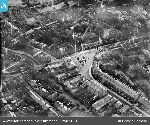
EPW023324 ENGLAND (1928). The junction of the High Street and Bridge Street, Winchester, 1928
© Copyright OpenStreetMap contributors and licensed by the OpenStreetMap Foundation. 2025. Cartography is licensed as CC BY-SA.
Nearby Images (7)
Details
| Title | [EPW023324] The junction of the High Street and Bridge Street, Winchester, 1928 |
| Reference | EPW023324 |
| Date | September-1928 |
| Link | |
| Place name | WINCHESTER |
| Parish | |
| District | |
| Country | ENGLAND |
| Easting / Northing | 448556, 129321 |
| Longitude / Latitude | -1.3070459037831, 51.060637440561 |
| National Grid Reference | SU486293 |
Pins
 David960 |
Thursday 29th of January 2015 05:57:05 PM | |
 Class31 |
Friday 26th of September 2014 07:55:36 PM | |
 Class31 |
Friday 26th of September 2014 07:54:44 PM | |
 Class31 |
Friday 26th of September 2014 07:54:02 PM | |
 Alan McFaden |
Monday 25th of November 2013 06:32:06 PM | |
 RG |
Tuesday 26th of June 2012 08:59:44 AM | |
 RG |
Tuesday 26th of June 2012 08:58:43 AM |
User Comment Contributions
City Mill, Winchester, 25/09/2014 |
 Class31 |
Friday 26th of September 2014 07:53:24 PM |
Can see the weirs and Abbet Grounds and the tree lined island leads to Easgate Street. The small lane in the bottom left hand corner must be Water Lane which had the Itchen River along one side. There was a large derelict mill at the end of Water Lane which provided hours of adventure for local children in the 40s ad 50s. |
 cook |
Saturday 30th of June 2012 03:12:22 PM |


![[EPW023324] The junction of the High Street and Bridge Street, Winchester, 1928](http://britainfromabove.org.uk/sites/all/libraries/aerofilms-images/public/100x100/EPW/023/EPW023324.jpg)
![[EPW023329] The High Street, Abbey Grounds and statue of King Alfred, Winchester, 1928](http://britainfromabove.org.uk/sites/all/libraries/aerofilms-images/public/100x100/EPW/023/EPW023329.jpg)
![[EAW051300] Wolvesey Castle and the surrounding city, Winchester, 1953](http://britainfromabove.org.uk/sites/all/libraries/aerofilms-images/public/100x100/EAW/051/EAW051300.jpg)
![[EAW008850] The Broadway and city centre, Winchester, 1947](http://britainfromabove.org.uk/sites/all/libraries/aerofilms-images/public/100x100/EAW/008/EAW008850.jpg)
![[EAW022308] The High Street and Cathedral of the Holy Trinity looking towards St Giles's Hill, Winchester, from the west, 1949](http://britainfromabove.org.uk/sites/all/libraries/aerofilms-images/public/100x100/EAW/022/EAW022308.jpg)
![[EAW035261] Wolvesey Palace, Winchester, 1951](http://britainfromabove.org.uk/sites/all/libraries/aerofilms-images/public/100x100/EAW/035/EAW035261.jpg)
![[EAW035262] Wolvesey Palace, Winchester, 1951](http://britainfromabove.org.uk/sites/all/libraries/aerofilms-images/public/100x100/EAW/035/EAW035262.jpg)
