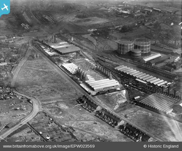
EPW023569 ENGLAND (1928). The Etruria Pottery Works and environs, Etruria, 1928
© Copyright OpenStreetMap contributors and licensed by the OpenStreetMap Foundation. 2025. Cartography is licensed as CC BY-SA.
Nearby Images (30)
Details
| Title | [EPW023569] The Etruria Pottery Works and environs, Etruria, 1928 |
| Reference | EPW023569 |
| Date | September-1928 |
| Link | |
| Place name | ETRURIA |
| Parish | |
| District | |
| Country | ENGLAND |
| Easting / Northing | 386627, 346670 |
| Longitude / Latitude | -2.1993657127841, 53.016857304939 |
| National Grid Reference | SJ866467 |
Pins
Be the first to add a comment to this image!


![[EPW023569] The Etruria Pottery Works and environs, Etruria, 1928](http://britainfromabove.org.uk/sites/all/libraries/aerofilms-images/public/100x100/EPW/023/EPW023569.jpg)
![[EPW023570] The Etruria Pottery Works and environs, Etruria, 1928](http://britainfromabove.org.uk/sites/all/libraries/aerofilms-images/public/100x100/EPW/023/EPW023570.jpg)
![[EPW023568] The Etruria Pottery Works and environs, Etruria, 1928](http://britainfromabove.org.uk/sites/all/libraries/aerofilms-images/public/100x100/EPW/023/EPW023568.jpg)
![[EPW026978] The Etruria Pottery and environs, Hartshill, 1929](http://britainfromabove.org.uk/sites/all/libraries/aerofilms-images/public/100x100/EPW/026/EPW026978.jpg)
![[EPW026970] The Etruria Pottery and environs, Hartshill, 1929](http://britainfromabove.org.uk/sites/all/libraries/aerofilms-images/public/100x100/EPW/026/EPW026970.jpg)
![[EPW023571] The Etruria Pottery Works and environs, Etruria, 1928](http://britainfromabove.org.uk/sites/all/libraries/aerofilms-images/public/100x100/EPW/023/EPW023571.jpg)
![[EPW026969] The Etruria Pottery and environs, Hartshill, 1929](http://britainfromabove.org.uk/sites/all/libraries/aerofilms-images/public/100x100/EPW/026/EPW026969.jpg)
![[EPW026968] The Etruria Pottery and environs, Hartshill, 1929](http://britainfromabove.org.uk/sites/all/libraries/aerofilms-images/public/100x100/EPW/026/EPW026968.jpg)
![[EPW020065] The Etruria Pottery and the Etruscan Street Gasworks, Hartshill, 1927](http://britainfromabove.org.uk/sites/all/libraries/aerofilms-images/public/100x100/EPW/020/EPW020065.jpg)
![[EPW026974] The Etruria Pottery and environs, Hartshill, 1929](http://britainfromabove.org.uk/sites/all/libraries/aerofilms-images/public/100x100/EPW/026/EPW026974.jpg)
![[EPW026977] The Etruria Pottery and environs, Hartshill, 1929](http://britainfromabove.org.uk/sites/all/libraries/aerofilms-images/public/100x100/EPW/026/EPW026977.jpg)
![[EPW026971] The Etruria Pottery and environs, Hartshill, 1929](http://britainfromabove.org.uk/sites/all/libraries/aerofilms-images/public/100x100/EPW/026/EPW026971.jpg)
![[EPW038491] The Wengers Ltd Ceramic Colour and Chemical Works and environs, Stoke-on-Trent, 1932](http://britainfromabove.org.uk/sites/all/libraries/aerofilms-images/public/100x100/EPW/038/EPW038491.jpg)
![[EAW021618] Wengers Ltd Ceramic Colour and Chemical Works, Etruria, 1949. This image has been produced from a print marked by Aerofilms Ltd for photo editing.](http://britainfromabove.org.uk/sites/all/libraries/aerofilms-images/public/100x100/EAW/021/EAW021618.jpg)
![[EPW038484] The Basford Tileries and environs, Stoke-on-Trent, 1932](http://britainfromabove.org.uk/sites/all/libraries/aerofilms-images/public/100x100/EPW/038/EPW038484.jpg)
![[EPW038486] The Basford Tileries, Stoke-on-Trent, 1932](http://britainfromabove.org.uk/sites/all/libraries/aerofilms-images/public/100x100/EPW/038/EPW038486.jpg)
![[EAW021621] Wengers Ltd Ceramic Colour and Chemical Works, Etruria, 1949. This image has been produced from a print marked by Aerofilms Ltd for photo editing.](http://britainfromabove.org.uk/sites/all/libraries/aerofilms-images/public/100x100/EAW/021/EAW021621.jpg)
![[EPW038492] The Wengers Ltd Ceramic Colour and Chemical Works and environs, Stoke-on-Trent, 1932](http://britainfromabove.org.uk/sites/all/libraries/aerofilms-images/public/100x100/EPW/038/EPW038492.jpg)
![[EPW038487] The Basford Tileries, Stoke-on-Trent, 1932](http://britainfromabove.org.uk/sites/all/libraries/aerofilms-images/public/100x100/EPW/038/EPW038487.jpg)
![[EPW038489] The Wengers Ltd Ceramic Colour and Chemical Works, Stoke-on-Trent, 1932](http://britainfromabove.org.uk/sites/all/libraries/aerofilms-images/public/100x100/EPW/038/EPW038489.jpg)
![[EAW021620] Wengers Ltd Ceramic Colour and Chemical Works and environs, Etruria, 1949. This image has been produced from a print marked by Aerofilms Ltd for photo editing.](http://britainfromabove.org.uk/sites/all/libraries/aerofilms-images/public/100x100/EAW/021/EAW021620.jpg)
![[EPW038483] The Basford Tileries and environs, Stoke-on-Trent, 1932](http://britainfromabove.org.uk/sites/all/libraries/aerofilms-images/public/100x100/EPW/038/EPW038483.jpg)
![[EPW038493] The Wengers Ltd Ceramic Colour and Chemical Works and the Albion Pottery Works, Stoke-on-Trent, 1932](http://britainfromabove.org.uk/sites/all/libraries/aerofilms-images/public/100x100/EPW/038/EPW038493.jpg)
![[EPW038485] Wengers Ltd. Ceramic Colour and Chemical Works, the Basford Tileries and environs, Stoke-on-Trent, 1932](http://britainfromabove.org.uk/sites/all/libraries/aerofilms-images/public/100x100/EPW/038/EPW038485.jpg)
![[EPW038482] The Basford Tileries, the Etruria Pottery Works and environs, Stoke-on-Trent, 1932](http://britainfromabove.org.uk/sites/all/libraries/aerofilms-images/public/100x100/EPW/038/EPW038482.jpg)
![[EAW021622] Wengers Ltd Ceramic Colour and Chemical Works, Etruria, 1949. This image has been produced from a print.](http://britainfromabove.org.uk/sites/all/libraries/aerofilms-images/public/100x100/EAW/021/EAW021622.jpg)
![[EAW020985] The Etruria Gas Works and environs, Stoke-on-Trent, 1949. This image has been produced from a print marked by Aerofilms Ltd for photo editing.](http://britainfromabove.org.uk/sites/all/libraries/aerofilms-images/public/100x100/EAW/020/EAW020985.jpg)
![[EAW021624] Wengers Ltd Ceramic Colour and Chemical Works and environs, Etruria, 1949. This image has been produced from a print marked by Aerofilms Ltd for photo editing.](http://britainfromabove.org.uk/sites/all/libraries/aerofilms-images/public/100x100/EAW/021/EAW021624.jpg)
![[EAW020979] Etruria Gas Works, Stoke-on-Trent, 1949. This image has been produced from a damaged negative.](http://britainfromabove.org.uk/sites/all/libraries/aerofilms-images/public/100x100/EAW/020/EAW020979.jpg)
![[EPW038490] The Wengers Ltd Ceramic Colour and Chemical Works and the Etruria Pottery Works, Stoke-on-Trent, 1932](http://britainfromabove.org.uk/sites/all/libraries/aerofilms-images/public/100x100/EPW/038/EPW038490.jpg)