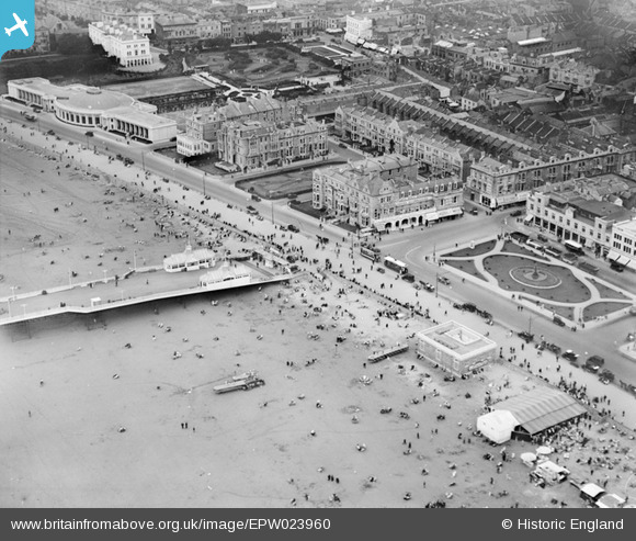
EPW023960 ENGLAND (1928). The Royal Parade, Weston-Super-Mare, 1928
© Copyright OpenStreetMap contributors and licensed by the OpenStreetMap Foundation. 2025. Cartography is licensed as CC BY-SA.
Nearby Images (19)
Details
| Title | [EPW023960] The Royal Parade, Weston-Super-Mare, 1928 |
| Reference | EPW023960 |
| Date | September-1928 |
| Link | |
| Place name | WESTON-SUPER-MARE |
| Parish | WESTON-SUPER-MARE |
| District | |
| Country | ENGLAND |
| Easting / Northing | 331733, 161400 |
| Longitude / Latitude | -2.9803213624275, 51.347074858751 |
| National Grid Reference | ST317614 |
Pins
 John W |
Tuesday 10th of January 2017 09:45:33 PM | |
 Alan McFaden |
Saturday 19th of October 2013 01:27:17 PM | |
 Alan McFaden |
Saturday 19th of October 2013 01:25:46 PM |


![[EPW023960] The Royal Parade, Weston-Super-Mare, 1928](http://britainfromabove.org.uk/sites/all/libraries/aerofilms-images/public/100x100/EPW/023/EPW023960.jpg)
![[EPW023970] The pier entrance, Weston-Super-Mare, 1928](http://britainfromabove.org.uk/sites/all/libraries/aerofilms-images/public/100x100/EPW/023/EPW023970.jpg)
![[EAW015057] Marine Parade and the town, Weston-super-Mare, from the south-west, 1948. This image has been produced from a damaged negative.](http://britainfromabove.org.uk/sites/all/libraries/aerofilms-images/public/100x100/EAW/015/EAW015057.jpg)
![[EPW048457] The Grand Pier and the town, Weston-Super-Mare, from the south, 1935](http://britainfromabove.org.uk/sites/all/libraries/aerofilms-images/public/100x100/EPW/048/EPW048457.jpg)
![[EPW039932] Marine Parade, Weston-super-Mare, 1932](http://britainfromabove.org.uk/sites/all/libraries/aerofilms-images/public/100x100/EPW/039/EPW039932.jpg)
![[EAW025155] Crowds on the beach near the entrance to the Grand Pier, Weston-super-Mare, 1949](http://britainfromabove.org.uk/sites/all/libraries/aerofilms-images/public/100x100/EAW/025/EAW025155.jpg)
![[EPW051716] Marine Parade by the Grand Pier and the town, Weston-super-Mare, from the south-west, 1936. This image has been produced from a copy-negative.](http://britainfromabove.org.uk/sites/all/libraries/aerofilms-images/public/100x100/EPW/051/EPW051716.jpg)
![[EAW015056] Marine Parade and the town, Weston-super-Mare, 1948. This image has been produced from a damaged negative.](http://britainfromabove.org.uk/sites/all/libraries/aerofilms-images/public/100x100/EAW/015/EAW015056.jpg)
![[EPW048443] The Grand Pier, Weston Bay and the town, Weston-Super-Mare, from the south-east, 1935](http://britainfromabove.org.uk/sites/all/libraries/aerofilms-images/public/100x100/EPW/048/EPW048443.jpg)
![[EPW001039] View over Weston-Super-Mare and the Grand Pier, Weston-Super-Mare, from the south-west, 1920](http://britainfromabove.org.uk/sites/all/libraries/aerofilms-images/public/100x100/EPW/001/EPW001039.jpg)
![[EPW048456] The Grand Pier and the town, Weston-Super-Mare, from the south, 1935](http://britainfromabove.org.uk/sites/all/libraries/aerofilms-images/public/100x100/EPW/048/EPW048456.jpg)
![[EPW039936] Marine Parade, Beach Road and environs, Weston-super-Mare, 1932](http://britainfromabove.org.uk/sites/all/libraries/aerofilms-images/public/100x100/EPW/039/EPW039936.jpg)
![[EPW039934] The Grand Pier and the beach, Weston-super-Mare, from the south-east, 1932](http://britainfromabove.org.uk/sites/all/libraries/aerofilms-images/public/100x100/EPW/039/EPW039934.jpg)
![[EAW016133] Grand Pier and the seafront, Weston-Super-Mare, from the south-east, 1948. This image has been produced from a damaged negative.](http://britainfromabove.org.uk/sites/all/libraries/aerofilms-images/public/100x100/EAW/016/EAW016133.jpg)
![[EPW023969] The Royal Parade, Winter Gardens and Model Yacht Pond, Weston-Super-Mare, 1928](http://britainfromabove.org.uk/sites/all/libraries/aerofilms-images/public/100x100/EPW/023/EPW023969.jpg)
![[EPW051708] The Winter Gardens Pavilion, Weston-super-Mare, 1936. This image has been produced from a copy-negative.](http://britainfromabove.org.uk/sites/all/libraries/aerofilms-images/public/100x100/EPW/051/EPW051708.jpg)
![[EAW056067] Worlebury Hill and the sea front, Weston-super-Mare, from the south-east, 1954](http://britainfromabove.org.uk/sites/all/libraries/aerofilms-images/public/100x100/EAW/056/EAW056067.jpg)
![[EAW016134] Grand Pier and the seafront, Weston-Super-Mare, from the south, 1948. This image has been produced from a damaged negative.](http://britainfromabove.org.uk/sites/all/libraries/aerofilms-images/public/100x100/EAW/016/EAW016134.jpg)
![[EAW015058] The Grand Pier and Marine Parade, Weston-super-Mare, 1948. This image has been produced from a damaged negative.](http://britainfromabove.org.uk/sites/all/libraries/aerofilms-images/public/100x100/EAW/015/EAW015058.jpg)

