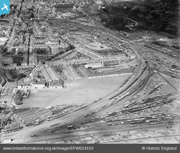
EPW024153 ENGLAND (1928). The Avon Malleable Iron Works, the Barton area of the city and part of the railway triangle, Gloucester, 1928
© Copyright OpenStreetMap contributors and licensed by the OpenStreetMap Foundation. 2024. Cartography is licensed as CC BY-SA.
Nearby Images (5)
Details
| Title | [EPW024153] The Avon Malleable Iron Works, the Barton area of the city and part of the railway triangle, Gloucester, 1928 |
| Reference | EPW024153 |
| Date | September-1928 |
| Link | |
| Place name | GLOUCESTER |
| Parish | |
| District | |
| Country | ENGLAND |
| Easting / Northing | 384373, 217879 |
| Longitude / Latitude | -2.2269399921822, 51.858836325068 |
| National Grid Reference | SO844179 |
Pins
 Kellysmartie |
Thursday 11th of June 2015 01:44:27 AM | |
 Class31 |
Thursday 4th of June 2015 08:20:49 AM | |
 Class31 |
Thursday 4th of June 2015 08:18:53 AM | |
 Class31 |
Thursday 4th of June 2015 08:18:08 AM | |
 galatea |
Saturday 7th of February 2015 03:18:05 PM | |
 galatea |
Saturday 7th of February 2015 03:16:46 PM | |
 galatea |
Saturday 7th of February 2015 03:15:26 PM | |
 Class31 |
Wednesday 23rd of January 2013 11:13:01 PM | |
I believe this is the bridge with notices at both ends asking for squads of soldiers to break step so as there will not be vibration damage done to the bridge. |
 John Wass |
Tuesday 23rd of March 2021 08:35:17 PM |
 Trebor |
Tuesday 28th of August 2012 09:06:43 AM | |
 Trebor |
Tuesday 28th of August 2012 09:03:49 AM | |
 Trebor |
Tuesday 28th of August 2012 09:02:56 AM |


![[EPW024153] The Avon Malleable Iron Works, the Barton area of the city and part of the railway triangle, Gloucester, 1928](http://britainfromabove.org.uk/sites/all/libraries/aerofilms-images/public/100x100/EPW/024/EPW024153.jpg)
![[EPW006133] Gloucester Co-Operative and Industrial Society Ltd, Gloucester, from the south-east, 1921](http://britainfromabove.org.uk/sites/all/libraries/aerofilms-images/public/100x100/EPW/006/EPW006133.jpg)
![[EPW041493] The railway triangle and environs, Gloucester, from the south-east, 1933](http://britainfromabove.org.uk/sites/all/libraries/aerofilms-images/public/100x100/EPW/041/EPW041493.jpg)
![[EPW038351] The Swindon and Gloucester Railway at Barnwood Junction, Gloucester, 1932](http://britainfromabove.org.uk/sites/all/libraries/aerofilms-images/public/100x100/EPW/038/EPW038351.jpg)
![[EPW048215] Sidney Street, the Gloucester Shirt Co on Magdala Road and surrounding area, Barton, from the east, 1935](http://britainfromabove.org.uk/sites/all/libraries/aerofilms-images/public/100x100/EPW/048/EPW048215.jpg)