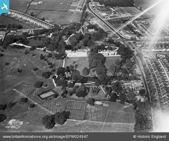
EPW024947 ENGLAND (1928). Gunnersbury Park House and Large Mansion, Gunnersbury Park, 1928
© Copyright OpenStreetMap contributors and licensed by the OpenStreetMap Foundation. 2025. Cartography is licensed as CC BY-SA.
Details
| Title | [EPW024947] Gunnersbury Park House and Large Mansion, Gunnersbury Park, 1928 |
| Reference | EPW024947 |
| Date | 6-October-1928 |
| Link | |
| Place name | GUNNERSBURY PARK |
| Parish | |
| District | |
| Country | ENGLAND |
| Easting / Northing | 519105, 179161 |
| Longitude / Latitude | -0.28394475268497, 51.498340321806 |
| National Grid Reference | TQ191792 |
Pins
 houds |
Sunday 19th of October 2014 10:08:50 PM | |
 houds |
Sunday 19th of October 2014 10:07:57 PM | |
 houds |
Sunday 19th of October 2014 10:07:30 PM | |
 Stu |
Tuesday 29th of January 2013 03:39:11 PM | |
 Class31 |
Thursday 22nd of November 2012 09:02:02 AM | |
 Class31 |
Wednesday 21st of November 2012 10:24:54 PM |


![[EPW024947] Gunnersbury Park House and Large Mansion, Gunnersbury Park, 1928](http://britainfromabove.org.uk/sites/all/libraries/aerofilms-images/public/100x100/EPW/024/EPW024947.jpg)
![[EPW025234] Gunnersbury Park including the Large and Small Mansions, Brentford, 1928](http://britainfromabove.org.uk/sites/all/libraries/aerofilms-images/public/100x100/EPW/025/EPW025234.jpg)