
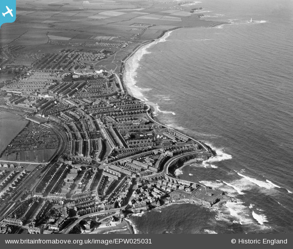
EPW025031 ENGLAND (1928). Cullercoats and Monkseaton, Whitley Bay, from the south-east, 1928
© Copyright OpenStreetMap contributors and licensed by the OpenStreetMap Foundation. 2025. Cartography is licensed as CC BY-SA.
Nearby Images (4)
EPW025031

EPW019765

EPW019772

EAW022859

Details
| Title | [EPW025031] Cullercoats and Monkseaton, Whitley Bay, from the south-east, 1928 |
| Reference | EPW025031 |
| Date | 12-October-1928 |
| Link | |
| Place name | WHITLEY BAY |
| Parish | |
| District | |
| Country | ENGLAND |
| Easting / Northing | 436286, 571674 |
| Longitude / Latitude | -1.4321548685807, 55.038186776488 |
| National Grid Reference | NZ363717 |
Pins
 reaper |
Thursday 2nd of April 2020 05:01:41 PM | |
reaper |
Thursday 2nd of April 2020 05:00:03 PM | |
reaper |
Thursday 2nd of April 2020 04:58:56 PM | |
reaper |
Thursday 2nd of April 2020 04:54:24 PM | |
reaper |
Thursday 2nd of April 2020 04:53:31 PM | |
reaper |
Thursday 2nd of April 2020 04:50:53 PM | |
RichardG |
Wednesday 11th of July 2018 10:40:17 AM | |
reaper |
Sunday 7th of December 2014 06:48:10 PM | |
reaper |
Sunday 7th of December 2014 06:46:06 PM | |
reaper |
Sunday 7th of December 2014 06:45:07 PM | |
Potter |
Friday 28th of November 2014 05:36:24 PM | |
cheviotwalks |
Wednesday 15th of October 2014 11:06:35 PM | |
cheviotwalks |
Wednesday 15th of October 2014 11:05:27 PM | |
cheviotwalks |
Wednesday 15th of October 2014 11:04:45 PM | |
cheviotwalks |
Wednesday 15th of October 2014 11:03:41 PM | |
cheviotwalks |
Wednesday 15th of October 2014 11:00:00 PM | |
cheviotwalks |
Wednesday 15th of October 2014 10:59:06 PM | |
cheviotwalks |
Wednesday 15th of October 2014 10:58:09 PM | |
cheviotwalks |
Wednesday 15th of October 2014 10:57:31 PM | |
cheviotwalks |
Wednesday 15th of October 2014 10:56:40 PM | |
micksharp |
Saturday 4th of October 2014 03:45:41 PM | |
 John Swain |
Thursday 22nd of August 2013 08:53:44 AM | |
John Swain |
Wednesday 21st of August 2013 07:46:13 PM | |
John Swain |
Wednesday 21st of August 2013 07:45:04 PM | |
John Swain |
Wednesday 21st of August 2013 07:44:02 PM | |
John Swain |
Wednesday 21st of August 2013 07:43:20 PM | |
John Swain |
Wednesday 21st of August 2013 07:42:48 PM | |
John Swain |
Wednesday 21st of August 2013 07:42:04 PM | |
John Swain |
Wednesday 21st of August 2013 07:40:53 PM | |
John Swain |
Wednesday 21st of August 2013 07:40:16 PM | |
John Swain |
Wednesday 21st of August 2013 07:39:02 PM | |
John Swain |
Wednesday 21st of August 2013 07:37:34 PM | |
John Swain |
Wednesday 21st of August 2013 07:35:48 PM | |
John Swain |
Wednesday 21st of August 2013 07:32:51 PM | |
John Swain |
Wednesday 21st of August 2013 07:25:01 PM | |
John Swain |
Wednesday 21st of August 2013 07:24:26 PM | |
John Swain |
Wednesday 21st of August 2013 07:23:37 PM | |
John Swain |
Wednesday 21st of August 2013 07:23:02 PM | |
Also known as Marconi Point & site of the now defunct Cullercoats Radio Station. |
cheviotwalks |
Wednesday 15th of October 2014 11:10:23 PM |
John Swain |
Wednesday 21st of August 2013 07:22:09 PM |
User Comment Contributions
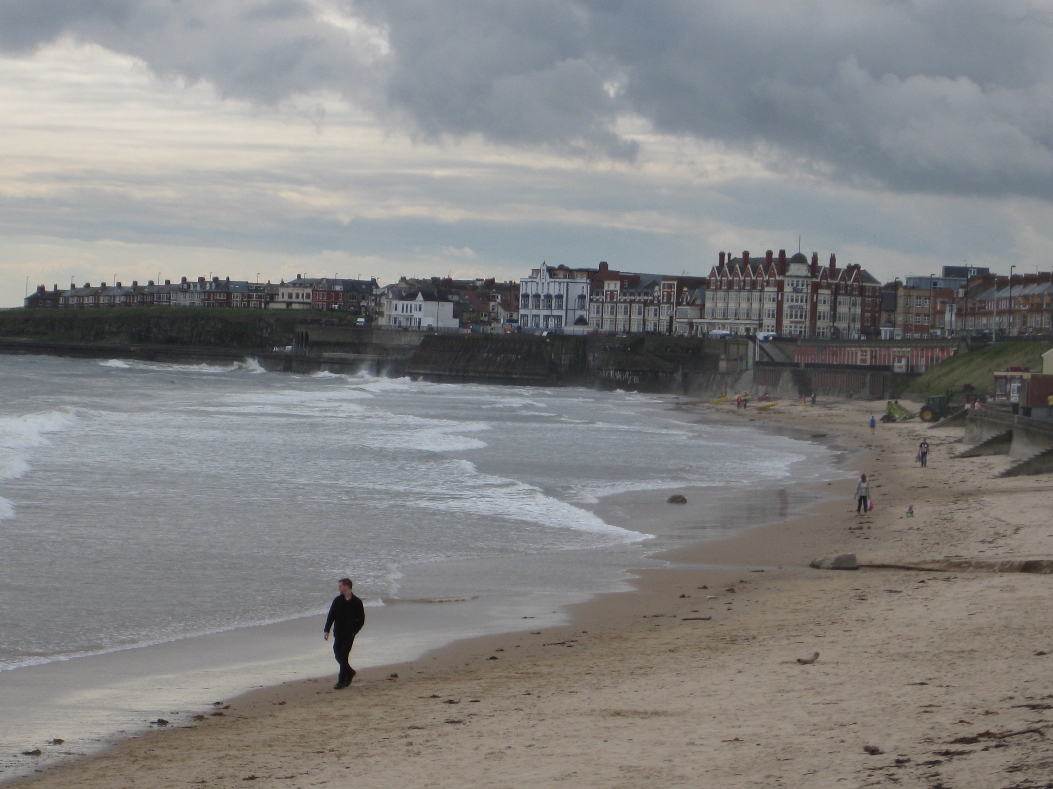 Looking south-east from The Links at Whitley Bay, towards Cullercoats and the fine old Victorian/Edwardian buildings along the Promenade, with Whitley Sands in the foreground. June 2012. |
John Swain |
Thursday 22nd of August 2013 09:30:37 AM |
Whitley Bay's growth took off in the late 19th century, from a small village of 300 inhabitants in 1861 to a bustling resort town of 6,800 in 1901. After the North Tyneside Loop Railway line was constructed in 1882, connecting the coastal villages to Newcastle, the natural attractions of the sea-front favoured dormitory and resort development at Whitley Bay, Monkseaton and Cullercoats. This area was also popular with many Glaswegians, both for holidays and day-trips, at least until the outbreak of World war II in 1939. Since 1920, Whitley Bay has expanded in a south-easterly direction towards Cullercoats, along the coast beyond Whitley Park and inland to absorb Monkseaton, so that the built-up area had increased four-fold between 1901 and 1925. Much of this rapid development is apparent in this image from October 1928, when the population of the town was probably in excess of 25,000. Further development continued throughout the 1930s, northwards along the coast and west towards Shiremoor. Today's population of Whitley Bay is estimated to be over 36,500 and it remains a very popular place, both for commuters and holiday-makers. |
John Swain |
Thursday 22nd of August 2013 09:19:03 AM |