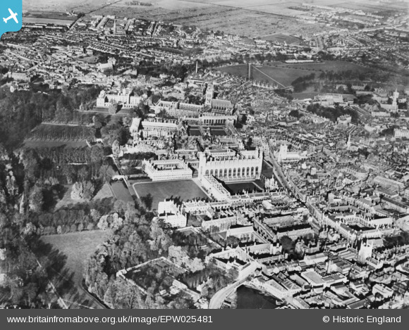
EPW025481 ENGLAND (1928). The Colleges, Cambridge, 1928. This image has been produced from a copy-negative.
© Copyright OpenStreetMap contributors and licensed by the OpenStreetMap Foundation. 2025. Cartography is licensed as CC BY-SA.
Nearby Images (48)
Details
| Title | [EPW025481] The Colleges, Cambridge, 1928. This image has been produced from a copy-negative. |
| Reference | EPW025481 |
| Date | 14-November-1928 |
| Link | |
| Place name | CAMBRIDGE |
| Parish | |
| District | |
| Country | ENGLAND |
| Easting / Northing | 544681, 258383 |
| Longitude / Latitude | 0.11747208168892, 52.204255188397 |
| National Grid Reference | TL447584 |
Pins
Be the first to add a comment to this image!
User Comment Contributions
14th November?? There seems to be an awful lot of leafage on the trees! |
 jon m |
Friday 5th of December 2014 09:45:02 AM |


![[EPW025481] The Colleges, Cambridge, 1928. This image has been produced from a copy-negative.](http://britainfromabove.org.uk/sites/all/libraries/aerofilms-images/public/100x100/EPW/025/EPW025481.jpg)
![[EAW002917] Kings College Chapel, Clare College and Trinity College, Cambridge, 1946](http://britainfromabove.org.uk/sites/all/libraries/aerofilms-images/public/100x100/EAW/002/EAW002917.jpg)
![[EPW009782] Colleges on The Backs, Cambridge, 1924](http://britainfromabove.org.uk/sites/all/libraries/aerofilms-images/public/100x100/EPW/009/EPW009782.jpg)
![[EPW059038] King's College Chapel and the city centre, Cambridge, 1938](http://britainfromabove.org.uk/sites/all/libraries/aerofilms-images/public/100x100/EPW/059/EPW059038.jpg)
![[EPW000046] Kings College Chapel and Clare College, Cambridge, 1920](http://britainfromabove.org.uk/sites/all/libraries/aerofilms-images/public/100x100/EPW/000/EPW000046.jpg)
![[EPW025478] King's College, Cambridge, 1928. This image has been produced from a copy-negative.](http://britainfromabove.org.uk/sites/all/libraries/aerofilms-images/public/100x100/EPW/025/EPW025478.jpg)
![[EAW011270] King's College Chapel, Cambridge, 1947](http://britainfromabove.org.uk/sites/all/libraries/aerofilms-images/public/100x100/EAW/011/EAW011270.jpg)
![[EPW009772] King's College, Cambridge, 1924](http://britainfromabove.org.uk/sites/all/libraries/aerofilms-images/public/100x100/EPW/009/EPW009772.jpg)
![[EPW009771] King's College, Cambridge, 1924](http://britainfromabove.org.uk/sites/all/libraries/aerofilms-images/public/100x100/EPW/009/EPW009771.jpg)
![[EPW000057] King's College, Cambridge, 1920](http://britainfromabove.org.uk/sites/all/libraries/aerofilms-images/public/100x100/EPW/000/EPW000057.jpg)
![[EPW059037] King's College Chapel and the city centre, Cambridge, 1938](http://britainfromabove.org.uk/sites/all/libraries/aerofilms-images/public/100x100/EPW/059/EPW059037.jpg)
![[EPW025476] St Catharine's College, King's College and Trinity College, Cambridge, 1928. This image has been produced from a copy-negative.](http://britainfromabove.org.uk/sites/all/libraries/aerofilms-images/public/100x100/EPW/025/EPW025476.jpg)
![[EPW045031] King's College, Trinity College and the town, Cambridge, from the south-west, 1934](http://britainfromabove.org.uk/sites/all/libraries/aerofilms-images/public/100x100/EPW/045/EPW045031.jpg)
![[EAW002925] Kings College, Trinity College and St John's College, Cambridge, 1946](http://britainfromabove.org.uk/sites/all/libraries/aerofilms-images/public/100x100/EAW/002/EAW002925.jpg)
![[EPW045030] King's College, Trinity College and the town, Cambridge, from the south, 1934](http://britainfromabove.org.uk/sites/all/libraries/aerofilms-images/public/100x100/EPW/045/EPW045030.jpg)
![[EAW003561] King's College and the city centre, Cambridge, from the south-west, 1947](http://britainfromabove.org.uk/sites/all/libraries/aerofilms-images/public/100x100/EAW/003/EAW003561.jpg)
![[EPW059036] King's College Chapel, Gonville and Caius College and Trinity College Great Court, Cambridge, 1938](http://britainfromabove.org.uk/sites/all/libraries/aerofilms-images/public/100x100/EPW/059/EPW059036.jpg)
![[EPW000053] Clare College, Cambridge, 1920](http://britainfromabove.org.uk/sites/all/libraries/aerofilms-images/public/100x100/EPW/000/EPW000053.jpg)
![[EAW002922] Kings College, Gonville and Caius College and Trinity College, Cambridge, 1946](http://britainfromabove.org.uk/sites/all/libraries/aerofilms-images/public/100x100/EAW/002/EAW002922.jpg)
![[EAW002918] St Catharine's College, Kings College Chapel and Trinity College, Cambridge, 1946](http://britainfromabove.org.uk/sites/all/libraries/aerofilms-images/public/100x100/EAW/002/EAW002918.jpg)
![[EAW012469] Bodley's Court, Cambridge, 1947](http://britainfromabove.org.uk/sites/all/libraries/aerofilms-images/public/100x100/EAW/012/EAW012469.jpg)
![[EPW000045] The Backs, Cambridge, 1920](http://britainfromabove.org.uk/sites/all/libraries/aerofilms-images/public/100x100/EPW/000/EPW000045.jpg)
![[EPW045033] King's College Chapel, Trinity College and the town, Cambridge, 1934](http://britainfromabove.org.uk/sites/all/libraries/aerofilms-images/public/100x100/EPW/045/EPW045033.jpg)
![[EAW002923] Kings College, Gonville and Caius College and Trinity College, Cambridge, 1946](http://britainfromabove.org.uk/sites/all/libraries/aerofilms-images/public/100x100/EAW/002/EAW002923.jpg)
![[EPW009779] Colleges on The Backs, Cambridge, 1924](http://britainfromabove.org.uk/sites/all/libraries/aerofilms-images/public/100x100/EPW/009/EPW009779.jpg)
![[EAW004873] The city centre, Cambridge, from the south-west, 1947](http://britainfromabove.org.uk/sites/all/libraries/aerofilms-images/public/100x100/EAW/004/EAW004873.jpg)
![[EAW004874] The city centre, Cambridge, from the south-west, 1947](http://britainfromabove.org.uk/sites/all/libraries/aerofilms-images/public/100x100/EAW/004/EAW004874.jpg)
![[EAW002916] Trinity College, Gonville and Caius College and Clare College, Cambridge, 1946](http://britainfromabove.org.uk/sites/all/libraries/aerofilms-images/public/100x100/EAW/002/EAW002916.jpg)
![[EPW045029] King's College, Trinity College and the town, Cambridge, from the south-west, 1934](http://britainfromabove.org.uk/sites/all/libraries/aerofilms-images/public/100x100/EPW/045/EPW045029.jpg)
![[EPW009781] Colleges on The Backs, Cambridge, 1924](http://britainfromabove.org.uk/sites/all/libraries/aerofilms-images/public/100x100/EPW/009/EPW009781.jpg)
![[EAW012463] Colleges on The Backs and the city, Cambridge, 1947](http://britainfromabove.org.uk/sites/all/libraries/aerofilms-images/public/100x100/EAW/012/EAW012463.jpg)
![[EAW012475] Queen's College Chapel and Friar's Court, Cambridge, 1947](http://britainfromabove.org.uk/sites/all/libraries/aerofilms-images/public/100x100/EAW/012/EAW012475.jpg)
![[EAW012462] Colleges on The Backs, Cambridge, 1947](http://britainfromabove.org.uk/sites/all/libraries/aerofilms-images/public/100x100/EAW/012/EAW012462.jpg)
![[EAW012477] Queen's College Chapel and environs, Cambridge, 1947](http://britainfromabove.org.uk/sites/all/libraries/aerofilms-images/public/100x100/EAW/012/EAW012477.jpg)
![[EAW012478] Queen's College and environs, Cambridge, 1947](http://britainfromabove.org.uk/sites/all/libraries/aerofilms-images/public/100x100/EAW/012/EAW012478.jpg)
![[EAW012474] Queen's College Chapel, the President's Garden and environs, Cambridge, 1947](http://britainfromabove.org.uk/sites/all/libraries/aerofilms-images/public/100x100/EAW/012/EAW012474.jpg)
![[EPW009777] Trinity College, Cambridge, 1924](http://britainfromabove.org.uk/sites/all/libraries/aerofilms-images/public/100x100/EPW/009/EPW009777.jpg)
![[EPW009784] Colleges on The Backs, Cambridge, 1924](http://britainfromabove.org.uk/sites/all/libraries/aerofilms-images/public/100x100/EPW/009/EPW009784.jpg)
![[EAW012464] Colleges off Trumpington Street and Silver Street and environs, Cambridge, 1947](http://britainfromabove.org.uk/sites/all/libraries/aerofilms-images/public/100x100/EAW/012/EAW012464.jpg)
![[EPW009776] Trinity College, Cambridge, 1924](http://britainfromabove.org.uk/sites/all/libraries/aerofilms-images/public/100x100/EPW/009/EPW009776.jpg)
![[EAW012476] Queen's College and environs, Cambridge, 1947](http://britainfromabove.org.uk/sites/all/libraries/aerofilms-images/public/100x100/EAW/012/EAW012476.jpg)
![[EAW012461] Queen's College and environs, Cambridge, 1947](http://britainfromabove.org.uk/sites/all/libraries/aerofilms-images/public/100x100/EAW/012/EAW012461.jpg)
![[EAW012468] Queen's College and Colleges off Trumpington Street, Cambridge, 1947](http://britainfromabove.org.uk/sites/all/libraries/aerofilms-images/public/100x100/EAW/012/EAW012468.jpg)
![[EAW012473] St Catharine's College and environs, Cambridge, 1947](http://britainfromabove.org.uk/sites/all/libraries/aerofilms-images/public/100x100/EAW/012/EAW012473.jpg)
![[EAW012472] Colleges on The Backs and environs, Cambridge, from the south, 1947](http://britainfromabove.org.uk/sites/all/libraries/aerofilms-images/public/100x100/EAW/012/EAW012472.jpg)
![[EPW009783] Colleges on The Backs, Cambridge, 1924](http://britainfromabove.org.uk/sites/all/libraries/aerofilms-images/public/100x100/EPW/009/EPW009783.jpg)
![[EAW012471] St Catharine's College and environs, Cambridge, 1947](http://britainfromabove.org.uk/sites/all/libraries/aerofilms-images/public/100x100/EAW/012/EAW012471.jpg)
![[EAW012460] Silver Street and environs, Cambridge, 1947. This image has been produced from a damaged negative.](http://britainfromabove.org.uk/sites/all/libraries/aerofilms-images/public/100x100/EAW/012/EAW012460.jpg)