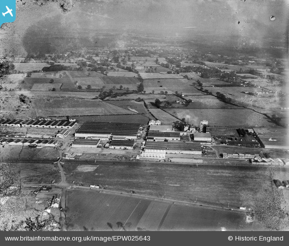
EPW025643 ENGLAND (1929). The Slough Trading Estate, Slough, from the south-west, 1929
© Copyright OpenStreetMap contributors and licensed by the OpenStreetMap Foundation. 2025. Cartography is licensed as CC BY-SA.
Nearby Images (13)
Details
| Title | [EPW025643] The Slough Trading Estate, Slough, from the south-west, 1929 |
| Reference | EPW025643 |
| Date | 26-January-1929 |
| Link | |
| Place name | SLOUGH |
| Parish | |
| District | |
| Country | ENGLAND |
| Easting / Northing | 495113, 181056 |
| Longitude / Latitude | -0.62898841606335, 51.519923636068 |
| National Grid Reference | SU951811 |


![[EPW025643] The Slough Trading Estate, Slough, from the south-west, 1929](http://britainfromabove.org.uk/sites/all/libraries/aerofilms-images/public/100x100/EPW/025/EPW025643.jpg)
![[EPW025652] D.M. Davies and Sons Multiple Woodwork Manufacturers on the Slough Trading Estate, Slough, 1929](http://britainfromabove.org.uk/sites/all/libraries/aerofilms-images/public/100x100/EPW/025/EPW025652.jpg)
![[EPW025654] D.M. Davies and Sons Multiple Woodwork Manufacturers on the Slough Trading Estate, Slough, 1929](http://britainfromabove.org.uk/sites/all/libraries/aerofilms-images/public/100x100/EPW/025/EPW025654.jpg)
![[EPW025653] D.M. Davies and Sons Multiple Woodwork Manufacturers on the Slough Trading Estate, Slough, 1929. This image has been produced from a damaged negative.](http://britainfromabove.org.uk/sites/all/libraries/aerofilms-images/public/100x100/EPW/025/EPW025653.jpg)
![[EPW025647] D.M. Davies and Sons Multiple Woodwork Manufacturers on the Slough Trading Estate, Slough, 1929](http://britainfromabove.org.uk/sites/all/libraries/aerofilms-images/public/100x100/EPW/025/EPW025647.jpg)
![[EPW025648] D.M. Davies and Sons Multiple Woodwork Manufacturers on the Slough Trading Estate, Slough, 1929. This image has been produced from a damaged negative.](http://britainfromabove.org.uk/sites/all/libraries/aerofilms-images/public/100x100/EPW/025/EPW025648.jpg)
![[EPW025650] D.M. Davies and Sons Multiple Woodwork Manufacturers on the Slough Trading Estate, Slough, 1929](http://britainfromabove.org.uk/sites/all/libraries/aerofilms-images/public/100x100/EPW/025/EPW025650.jpg)
![[EPW025651] D.M. Davies and Sons Multiple Woodwork Manufacturers on the Slough Trading Estate, Slough, 1929](http://britainfromabove.org.uk/sites/all/libraries/aerofilms-images/public/100x100/EPW/025/EPW025651.jpg)
![[EPW025646] D.M. Davies and Sons Multiple Woodwork Manufacturers on the Slough Trading Estate, Slough, 1929](http://britainfromabove.org.uk/sites/all/libraries/aerofilms-images/public/100x100/EPW/025/EPW025646.jpg)
![[EPW025649] D.M. Davies and Sons Multiple Woodwork Manufacturers on the Slough Trading Estate, Slough, 1929](http://britainfromabove.org.uk/sites/all/libraries/aerofilms-images/public/100x100/EPW/025/EPW025649.jpg)
![[EPW058332] The Slough Trading Estate and the surrounding area, Slough, 1938](http://britainfromabove.org.uk/sites/all/libraries/aerofilms-images/public/100x100/EPW/058/EPW058332.jpg)
![[EPW056618] The Slough Trading Estate, Slough, 1938. This image has been produced from a copy-negative.](http://britainfromabove.org.uk/sites/all/libraries/aerofilms-images/public/100x100/EPW/056/EPW056618.jpg)
![[EPW025661] The Estate Offices and various Works buildings including BeZeBe Honey and Gillette on the Slough Trading Estate, Slough, 1929](http://britainfromabove.org.uk/sites/all/libraries/aerofilms-images/public/100x100/EPW/025/EPW025661.jpg)
