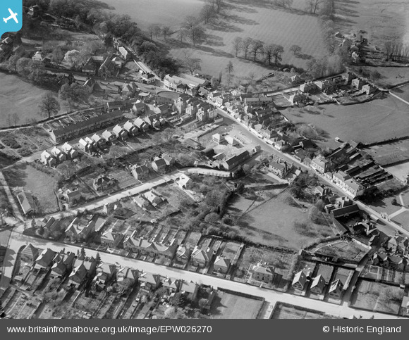
EPW026270 ENGLAND (1929). Limes Road and environs, Egham, 1929
© Copyright OpenStreetMap contributors and licensed by the OpenStreetMap Foundation. 2025. Cartography is licensed as CC BY-SA.
Details
| Title | [EPW026270] Limes Road and environs, Egham, 1929 |
| Reference | EPW026270 |
| Date | 25-April-1929 |
| Link | |
| Place name | EGHAM |
| Parish | |
| District | |
| Country | ENGLAND |
| Easting / Northing | 500721, 171226 |
| Longitude / Latitude | -0.55098179948689, 51.430582877359 |
| National Grid Reference | TQ007712 |
Pins
 David960 |
Tuesday 9th of May 2023 12:11:35 PM | |
 Ellensdottir |
Sunday 1st of September 2013 09:15:23 PM | |
 Ellensdottir |
Sunday 1st of September 2013 09:14:26 PM | |
 Ellensdottir |
Sunday 1st of September 2013 09:13:10 PM | |
 Class31 |
Tuesday 30th of October 2012 04:40:32 PM | |
 Class31 |
Tuesday 30th of October 2012 04:39:50 PM | |
 Class31 |
Tuesday 30th of October 2012 04:39:31 PM | |
 Class31 |
Tuesday 30th of October 2012 04:39:01 PM |


![[EPW026270] Limes Road and environs, Egham, 1929](http://britainfromabove.org.uk/sites/all/libraries/aerofilms-images/public/100x100/EPW/026/EPW026270.jpg)
![[EPW023511] The High Street and environs, Egham, 1928](http://britainfromabove.org.uk/sites/all/libraries/aerofilms-images/public/100x100/EPW/023/EPW023511.jpg)
![[EPW026269] The town, Egham, from the south-west, 1929](http://britainfromabove.org.uk/sites/all/libraries/aerofilms-images/public/100x100/EPW/026/EPW026269.jpg)
![[EAW002313] Egham Hill Roundabout, Runnymede Park and environs, Englefield Green, from the south, 1946](http://britainfromabove.org.uk/sites/all/libraries/aerofilms-images/public/100x100/EAW/002/EAW002313.jpg)