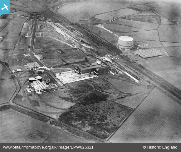
EPW026321 ENGLAND (1929). The Manchester Corporation Gas Works, Partington, 1929
© Copyright OpenStreetMap contributors and licensed by the OpenStreetMap Foundation. 2025. Cartography is licensed as CC BY-SA.
Nearby Images (21)
Details
| Title | [EPW026321] The Manchester Corporation Gas Works, Partington, 1929 |
| Reference | EPW026321 |
| Date | 29-April-1929 |
| Link | |
| Place name | PARTINGTON |
| Parish | PARTINGTON |
| District | |
| Country | ENGLAND |
| Easting / Northing | 372701, 391393 |
| Longitude / Latitude | -2.4107998877721, 53.418372669389 |
| National Grid Reference | SJ727914 |
Pins
 Bottom Yard |
Tuesday 26th of February 2019 02:32:06 PM | |
 Bottom Yard |
Tuesday 26th of February 2019 02:30:17 PM | |
 Bottom Yard |
Tuesday 26th of February 2019 02:19:08 PM | |
 John Ellis |
Thursday 12th of September 2013 12:44:50 PM | |
 John Ellis |
Thursday 12th of September 2013 12:43:31 PM | |
THIS IS PARTINGTON RAILWAY STATION, WITH TWO PLATFORMS. NOT THE THE ONE POINTING AT THE SHIP CANAL COALING SIDINGS EGIN SHED. |
 Bottom Yard |
Tuesday 26th of February 2019 02:20:38 PM |
 John Ellis |
Thursday 12th of September 2013 12:41:03 PM | |
 John Ellis |
Thursday 12th of September 2013 12:37:57 PM | |
 parrot |
Thursday 23rd of May 2013 08:49:22 PM |


![[EPW026321] The Manchester Corporation Gas Works, Partington, 1929](http://britainfromabove.org.uk/sites/all/libraries/aerofilms-images/public/100x100/EPW/026/EPW026321.jpg)
![[EPW026333] The Manchester Corporation Gas Works, Partington, 1929](http://britainfromabove.org.uk/sites/all/libraries/aerofilms-images/public/100x100/EPW/026/EPW026333.jpg)
![[EPW026331] The Manchester Corporation Gas Works, Partington, 1929](http://britainfromabove.org.uk/sites/all/libraries/aerofilms-images/public/100x100/EPW/026/EPW026331.jpg)
![[EPW026334] The Manchester Corporation Gas Works, Partington, 1929](http://britainfromabove.org.uk/sites/all/libraries/aerofilms-images/public/100x100/EPW/026/EPW026334.jpg)
![[EPW026335] The Manchester Corporation Gas Works, Partington, 1929](http://britainfromabove.org.uk/sites/all/libraries/aerofilms-images/public/100x100/EPW/026/EPW026335.jpg)
![[EPW026323] The Manchester Corporation Gas Works, Partington, 1929](http://britainfromabove.org.uk/sites/all/libraries/aerofilms-images/public/100x100/EPW/026/EPW026323.jpg)
![[EPW026332] The Manchester Corporation Gas Works, Partington, 1929](http://britainfromabove.org.uk/sites/all/libraries/aerofilms-images/public/100x100/EPW/026/EPW026332.jpg)
![[EPW026325] The Manchester Corporation Gas Works, Partington, 1929](http://britainfromabove.org.uk/sites/all/libraries/aerofilms-images/public/100x100/EPW/026/EPW026325.jpg)
![[EPW026324] The Manchester Corporation Gas Works, Partington, 1929](http://britainfromabove.org.uk/sites/all/libraries/aerofilms-images/public/100x100/EPW/026/EPW026324.jpg)
![[EPW026326] The Manchester Corporation Gas Works, Partington, 1929](http://britainfromabove.org.uk/sites/all/libraries/aerofilms-images/public/100x100/EPW/026/EPW026326.jpg)
![[EPW026329] The Manchester Corporation Gas Works, Partington, 1929](http://britainfromabove.org.uk/sites/all/libraries/aerofilms-images/public/100x100/EPW/026/EPW026329.jpg)
![[EPW026327] The Manchester Corporation Gas Works, Partington, 1929](http://britainfromabove.org.uk/sites/all/libraries/aerofilms-images/public/100x100/EPW/026/EPW026327.jpg)
![[EPW026330] The Manchester Corporation Gas Works, Partington, 1929](http://britainfromabove.org.uk/sites/all/libraries/aerofilms-images/public/100x100/EPW/026/EPW026330.jpg)
![[EPW026322] The Manchester Corporation Gas Works, Partington, 1929](http://britainfromabove.org.uk/sites/all/libraries/aerofilms-images/public/100x100/EPW/026/EPW026322.jpg)
![[EPW026328] The Manchester Corporation Gas Works, Carrington, 1929](http://britainfromabove.org.uk/sites/all/libraries/aerofilms-images/public/100x100/EPW/026/EPW026328.jpg)
![[EPR000256] The Manchester Corporation Partington Gas Works, Partington, 1934](http://britainfromabove.org.uk/sites/all/libraries/aerofilms-images/public/100x100/EPR/000/EPR000256.jpg)
![[EPR000252] The Manchester Corporation Partington Gas Works, Carrington, 1934](http://britainfromabove.org.uk/sites/all/libraries/aerofilms-images/public/100x100/EPR/000/EPR000252.jpg)
![[EPW062671] The Gas Works, Partington, 1939](http://britainfromabove.org.uk/sites/all/libraries/aerofilms-images/public/100x100/EPW/062/EPW062671.jpg)
![[EPR000254] The Manchester Corporation Partington Gas Works, Partington, 1934](http://britainfromabove.org.uk/sites/all/libraries/aerofilms-images/public/100x100/EPR/000/EPR000254.jpg)
![[EPR000255] The Manchester Corporation Partington Gas Works, Partington, 1934](http://britainfromabove.org.uk/sites/all/libraries/aerofilms-images/public/100x100/EPR/000/EPR000255.jpg)
![[EPR000253] The Manchester Corporation Partington Gas Works, Carrington, 1934. This image has been produced from a damaged negative.](http://britainfromabove.org.uk/sites/all/libraries/aerofilms-images/public/100x100/EPR/000/EPR000253.jpg)