
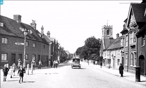
EPW026459 ENGLAND (1929). Ampthill Road and environs, Bedford, 1929

© Copyright OpenStreetMap contributors and licensed by the OpenStreetMap Foundation. 2025. Cartography is licensed as CC BY-SA.
Nearby Images (6)
EPW026459

EPW022384

EPW045601

EAW046971

EAW016098

EAW003715

Details
| Title | [EPW026459] Ampthill Road and environs, Bedford, 1929 |
| Reference | EPW026459 |
| Date | May-1929 |
| Link | |
| Place name | BEDFORD |
| Parish | |
| District | |
| Country | ENGLAND |
| Easting / Northing | 505149, 249058 |
| Longitude / Latitude | -0.46371836907046, 52.129401804054 |
| National Grid Reference | TL051491 |
Pins
 |
 melgibbs |
Monday 17th of August 2015 04:50:30 PM |
 |
melgibbs |
Monday 9th of December 2013 04:24:35 PM |
 |
melgibbs |
Monday 9th of December 2013 04:06:28 PM |
melgibbs |
Wednesday 12th of June 2013 06:56:39 PM | |
melgibbs |
Wednesday 12th of June 2013 06:54:51 PM | |
melgibbs |
Wednesday 12th of June 2013 06:54:03 PM | |
melgibbs |
Wednesday 12th of June 2013 06:51:33 PM | |
melgibbs |
Wednesday 12th of June 2013 06:50:47 PM | |
melgibbs |
Wednesday 12th of June 2013 06:48:43 PM | |
melgibbs |
Wednesday 12th of June 2013 06:48:16 PM | |
melgibbs |
Wednesday 12th of June 2013 06:44:06 PM | |
melgibbs |
Wednesday 12th of June 2013 06:43:19 PM | |
melgibbs |
Wednesday 12th of June 2013 06:42:32 PM | |
melgibbs |
Wednesday 12th of June 2013 06:38:57 PM | |
melgibbs |
Wednesday 12th of June 2013 10:26:43 AM | |
melgibbs |
Wednesday 12th of June 2013 10:24:15 AM | |
melgibbs |
Wednesday 12th of June 2013 10:21:10 AM | |
melgibbs |
Wednesday 12th of June 2013 10:20:30 AM | |
melgibbs |
Wednesday 12th of June 2013 10:19:23 AM | |
melgibbs |
Wednesday 12th of June 2013 10:17:12 AM | |
Born in 75 Pilcroft Street in 1948 (West side of the street) Very last family to move out before demolishion in 1962. The East side if the street (even numbers) were pulled down some years before to make way for The Kingsway, named so because it was built on the route of the Kings Brook. |
 Stuart C |
Saturday 25th of June 2016 08:20:31 PM |
melgibbs |
Wednesday 12th of June 2013 10:16:31 AM | |
melgibbs |
Wednesday 12th of June 2013 10:16:05 AM | |
melgibbs |
Wednesday 12th of June 2013 10:15:22 AM | |
melgibbs |
Wednesday 12th of June 2013 10:14:27 AM | |
melgibbs |
Wednesday 12th of June 2013 10:10:34 AM | |
melgibbs |
Saturday 20th of October 2012 03:14:35 PM | |
MB |
Tuesday 18th of September 2012 11:06:48 AM | |
MB |
Tuesday 18th of September 2012 11:05:05 AM | |
MB |
Tuesday 18th of September 2012 11:03:44 AM | |
MB |
Tuesday 18th of September 2012 11:01:52 AM | |
MB |
Tuesday 18th of September 2012 11:00:54 AM | |
MB |
Tuesday 18th of September 2012 11:00:00 AM | |
MB |
Tuesday 18th of September 2012 10:58:26 AM | |
My 1949-50 Kelly's Directory lists this as W.H. & J. Rogers flour mill. |
melgibbs |
Wednesday 12th of June 2013 10:12:53 AM |
MB |
Tuesday 18th of September 2012 10:57:47 AM | |
MB |
Tuesday 18th of September 2012 10:55:09 AM | |
MB |
Tuesday 18th of September 2012 10:53:04 AM | |
I think this is a building where Turners made the ropes and Rope Walk is nearer to where it is today. My copy of the 1949-50 Kelly's Directory has Rope Walk between numbers 50 & 54 St John's Street. |
melgibbs |
Wednesday 12th of June 2013 10:29:38 AM |
MB |
Tuesday 18th of September 2012 10:49:37 AM | |
MB |
Tuesday 18th of September 2012 10:47:03 AM | |
MB |
Tuesday 18th of September 2012 10:46:28 AM | |
MB |
Tuesday 18th of September 2012 10:45:23 AM | |
MB |
Tuesday 18th of September 2012 10:44:05 AM | |
Neil.j |
Monday 6th of August 2012 07:51:23 PM | |
Judging by the roof top shape and what I think is St John's Place, I think this is Hester's Cafe at number 43 St John's and The Pheonix pub is the next to the left, the other side of St John's Place. I've since added a photo from 1921 that shows The Pheonix pub. |
melgibbs |
Thursday 6th of August 2015 07:50:32 PM |
User Comment Contributions
My memory of Bedford St. John's Railway Station is of a very forlorn and unloved structure in about 1970. The line from Oxford to Cambridge had closed as a through route in 1968 with the section from Bletchley to Bedford St. John's remaining open. The line from Bletchley has now been routed into the main station in Bedford and St. John's on this site has been abandoned. There are thoughts of reopening the Oxford to Cambridge line so we may yet see trains running here. |
 Class31 |
Monday 17th of August 2015 04:42:44 PM |
I think the station's only claim to fame was that some of it was shown briefly in one of the Some Mother's Do 'Ave 'Em episodes (the super glue incident). |
melgibbs |
Monday 17th of August 2015 04:42:44 PM |
Can anyone remember which building was Brightmans (or Britemans?) Cycles. Was it the one to the right of The Phoenix pub or was it the one with large attic windows to the right of the church tower? |
 Jet |
Thursday 6th of August 2015 07:58:21 PM |
Brightman's was at number 29 St John's, between Maison Joan, a ladies hairdresser, and Moulang's the chemist so it is more than likely to the right of the church tower. It was where the high rise block of flats is now that was Telephone House. |
melgibbs |
Thursday 6th of August 2015 07:58:21 PM |
From the pin comments, this looks like the Ampthill Road in Bedford and not Biggleswade as mentioned in the title. |
melgibbs |
Saturday 20th of October 2012 10:14:55 AM |
This is of course Bedford, not Biggleswade. St. John's Station bottom left, St. John's Church extreme right. |
G Shortell |
Friday 6th of July 2012 04:31:34 PM |