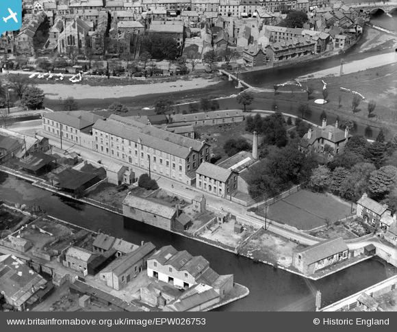
EPW026753 ENGLAND (1929). The Illingworth Snuff Factory and environs, Kendal, 1929
© Copyright OpenStreetMap contributors and licensed by the OpenStreetMap Foundation. 2025. Cartography is licensed as CC BY-SA.
Nearby Images (18)
Details
| Title | [EPW026753] The Illingworth Snuff Factory and environs, Kendal, 1929 |
| Reference | EPW026753 |
| Date | May-1929 |
| Link | |
| Place name | KENDAL |
| Parish | KENDAL |
| District | |
| Country | ENGLAND |
| Easting / Northing | 351901, 492651 |
| Longitude / Latitude | -2.739667374898, 54.327010081368 |
| National Grid Reference | SD519927 |
Pins
 Moonraker |
Wednesday 18th of October 2023 09:28:05 AM |


![[EPW026753] The Illingworth Snuff Factory and environs, Kendal, 1929](http://britainfromabove.org.uk/sites/all/libraries/aerofilms-images/public/100x100/EPW/026/EPW026753.jpg)
![[EPW026747] The Illingworth Snuff Factory and canal basin, Kendal, 1929](http://britainfromabove.org.uk/sites/all/libraries/aerofilms-images/public/100x100/EPW/026/EPW026747.jpg)
![[EPW026751] The Illingworth Snuff Factory and environs, Kendal, 1929](http://britainfromabove.org.uk/sites/all/libraries/aerofilms-images/public/100x100/EPW/026/EPW026751.jpg)
![[EPW026755] The Illingworth Snuff Factory and Gooseholme Bridge, Kendal, 1929](http://britainfromabove.org.uk/sites/all/libraries/aerofilms-images/public/100x100/EPW/026/EPW026755.jpg)
![[EPW026756] The Illingworth Snuff Factory and environs, Kendal, 1929](http://britainfromabove.org.uk/sites/all/libraries/aerofilms-images/public/100x100/EPW/026/EPW026756.jpg)
![[EPW026752] The Illingworth Snuff Factory and environs, Kendal, 1929](http://britainfromabove.org.uk/sites/all/libraries/aerofilms-images/public/100x100/EPW/026/EPW026752.jpg)
![[EPW026748] The Illingworth Snuff Factory and environs, Kendal, 1929](http://britainfromabove.org.uk/sites/all/libraries/aerofilms-images/public/100x100/EPW/026/EPW026748.jpg)
![[EPW026749] The Illingworth Snuff Factory and environs, Kendal, 1929](http://britainfromabove.org.uk/sites/all/libraries/aerofilms-images/public/100x100/EPW/026/EPW026749.jpg)
![[EPW026750] The Illingworth Snuff Factory and Goose Holme, Kendal, 1929](http://britainfromabove.org.uk/sites/all/libraries/aerofilms-images/public/100x100/EPW/026/EPW026750.jpg)
![[EPW026754] The Illingworth Snuff Factory, Kendal, 1929](http://britainfromabove.org.uk/sites/all/libraries/aerofilms-images/public/100x100/EPW/026/EPW026754.jpg)
![[EPW026746] The Illingworth Snuff Factory, Kendal, 1929](http://britainfromabove.org.uk/sites/all/libraries/aerofilms-images/public/100x100/EPW/026/EPW026746.jpg)
![[EPW026579] The town, Kendal, from the east, 1929](http://britainfromabove.org.uk/sites/all/libraries/aerofilms-images/public/100x100/EPW/026/EPW026579.jpg)
![[EPW026548] The town centre, Kendal, from the south-east, 1929](http://britainfromabove.org.uk/sites/all/libraries/aerofilms-images/public/100x100/EPW/026/EPW026548.jpg)
![[EAW043387] Kendal Castle overlooking the town, Kendal, 1952](http://britainfromabove.org.uk/sites/all/libraries/aerofilms-images/public/100x100/EAW/043/EAW043387.jpg)
![[EPW026540] Castle Carpet and Rug Mills, Kendal, 1929. This image has been affecetd by flare.](http://britainfromabove.org.uk/sites/all/libraries/aerofilms-images/public/100x100/EPW/026/EPW026540.jpg)
![[EAW043388] Kendal Castle, Kendal, 1952](http://britainfromabove.org.uk/sites/all/libraries/aerofilms-images/public/100x100/EAW/043/EAW043388.jpg)
![[EPW038827] Gooseholme Bridge and the town centre, Kendal, 1932](http://britainfromabove.org.uk/sites/all/libraries/aerofilms-images/public/100x100/EPW/038/EPW038827.jpg)
![[EAW014500] The town, Kendal, from the north-east, 1948](http://britainfromabove.org.uk/sites/all/libraries/aerofilms-images/public/100x100/EAW/014/EAW014500.jpg)