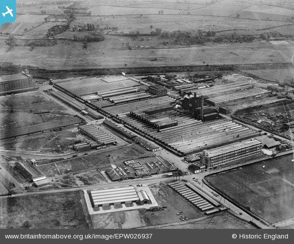
EPW026937 ENGLAND (1929). Fort Dunlop Rubber Works and Birmingham Racecourse, Bromford, 1929
© Copyright OpenStreetMap contributors and licensed by the OpenStreetMap Foundation. 2025. Cartography is licensed as CC BY-SA.
Nearby Images (21)
Details
| Title | [EPW026937] Fort Dunlop Rubber Works and Birmingham Racecourse, Bromford, 1929 |
| Reference | EPW026937 |
| Date | May-1929 |
| Link | |
| Place name | BROMFORD |
| Parish | |
| District | |
| Country | ENGLAND |
| Easting / Northing | 412523, 290440 |
| Longitude / Latitude | -1.8154556932678, 52.511340459753 |
| National Grid Reference | SP125904 |
Pins
 John Llewellyn |
Monday 30th of November 2015 07:27:39 PM | |
 MB |
Tuesday 5th of February 2013 10:27:20 AM |


![[EPW026937] Fort Dunlop Rubber Works and Birmingham Racecourse, Bromford, 1929](http://britainfromabove.org.uk/sites/all/libraries/aerofilms-images/public/100x100/EPW/026/EPW026937.jpg)
![[EPW026939] Fort Dunlop Rubber Works and Birmingham Racecourse, Bromford, 1929](http://britainfromabove.org.uk/sites/all/libraries/aerofilms-images/public/100x100/EPW/026/EPW026939.jpg)
![[EPW026940] Fort Dunlop Rubber Works, Bromford, 1929](http://britainfromabove.org.uk/sites/all/libraries/aerofilms-images/public/100x100/EPW/026/EPW026940.jpg)
![[EPW026943] Fort Dunlop Rubber Works, Bromford, 1929](http://britainfromabove.org.uk/sites/all/libraries/aerofilms-images/public/100x100/EPW/026/EPW026943.jpg)
![[EPW026934] Fort Dunlop Rubber Works and Birmingham Racecourse, Bromford, 1929](http://britainfromabove.org.uk/sites/all/libraries/aerofilms-images/public/100x100/EPW/026/EPW026934.jpg)
![[EPW026936] Fort Dunlop Rubber Works, Bromford, 1929](http://britainfromabove.org.uk/sites/all/libraries/aerofilms-images/public/100x100/EPW/026/EPW026936.jpg)
![[EPW025791] Fort Dunlop Rubber Works, Bromford, 1929. This image has been produced from a print.](http://britainfromabove.org.uk/sites/all/libraries/aerofilms-images/public/100x100/EPW/025/EPW025791.jpg)
![[EPW055214] The Fort Dunlop Rubber Works, Bromford, 1937](http://britainfromabove.org.uk/sites/all/libraries/aerofilms-images/public/100x100/EPW/055/EPW055214.jpg)
![[EPW001206] Rubber works and Birmingham Racecourse, Bromford, 1920](http://britainfromabove.org.uk/sites/all/libraries/aerofilms-images/public/100x100/EPW/001/EPW001206.jpg)
![[EPW055212] The Fort Dunlop Rubber Works, Bromford, from the south-west, 1937](http://britainfromabove.org.uk/sites/all/libraries/aerofilms-images/public/100x100/EPW/055/EPW055212.jpg)
![[EPW026935] Fort Dunlop Rubber Works, Bromford, 1929](http://britainfromabove.org.uk/sites/all/libraries/aerofilms-images/public/100x100/EPW/026/EPW026935.jpg)
![[EPW055216] The Fort Dunlop Rubber Works, Bromford, 1937](http://britainfromabove.org.uk/sites/all/libraries/aerofilms-images/public/100x100/EPW/055/EPW055216.jpg)
![[EPW026938] Fort Dunlop Rubber Works, Bromford, 1929](http://britainfromabove.org.uk/sites/all/libraries/aerofilms-images/public/100x100/EPW/026/EPW026938.jpg)
![[EPW026941] Fort Dunlop Rubber Works, Bromford, 1929. This image was marked by Aerofilms Ltd for photo editing.](http://britainfromabove.org.uk/sites/all/libraries/aerofilms-images/public/100x100/EPW/026/EPW026941.jpg)
![[EPW022581] Fort Dunlop Rubber Works, Bromford, 1928](http://britainfromabove.org.uk/sites/all/libraries/aerofilms-images/public/100x100/EPW/022/EPW022581.jpg)
![[EPW055215] The Fort Dunlop Rubber Works, Bromford, 1937](http://britainfromabove.org.uk/sites/all/libraries/aerofilms-images/public/100x100/EPW/055/EPW055215.jpg)
![[EPW055211] The Fort Dunlop Rubber Works, Bromford, 1937](http://britainfromabove.org.uk/sites/all/libraries/aerofilms-images/public/100x100/EPW/055/EPW055211.jpg)
![[EPW026933] Fort Dunlop Rubber Works, Bromford, 1929](http://britainfromabove.org.uk/sites/all/libraries/aerofilms-images/public/100x100/EPW/026/EPW026933.jpg)
![[EPW053751] The Fort Dunlop Rubber Works, Bromford, from the west, 1937](http://britainfromabove.org.uk/sites/all/libraries/aerofilms-images/public/100x100/EPW/053/EPW053751.jpg)
![[EPW055218] The Fort Dunlop Rubber Works, Bromford, from the south-east, 1937](http://britainfromabove.org.uk/sites/all/libraries/aerofilms-images/public/100x100/EPW/055/EPW055218.jpg)
![[EPW055217] The Fort Dunlop Rubber Works, Bromford, from the south-east, 1937](http://britainfromabove.org.uk/sites/all/libraries/aerofilms-images/public/100x100/EPW/055/EPW055217.jpg)