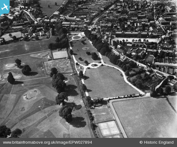
EPW027894 ENGLAND (1929). Vivary Park, Taunton, 1929. This image has been produced from a print.
© Copyright OpenStreetMap contributors and licensed by the OpenStreetMap Foundation. 2025. Cartography is licensed as CC BY-SA.
Details
| Title | [EPW027894] Vivary Park, Taunton, 1929. This image has been produced from a print. |
| Reference | EPW027894 |
| Date | 28-June-1929 |
| Link | |
| Place name | TAUNTON |
| Parish | |
| District | |
| Country | ENGLAND |
| Easting / Northing | 322833, 123991 |
| Longitude / Latitude | -3.1000672647023, 51.009579093175 |
| National Grid Reference | ST228240 |
Pins
 gBr |
Friday 28th of April 2017 01:26:54 PM |


![[EPW027894] Vivary Park, Taunton, 1929. This image has been produced from a print.](http://britainfromabove.org.uk/sites/all/libraries/aerofilms-images/public/100x100/EPW/027/EPW027894.jpg)
![[EPW041180] Jellalabad Barracks, Vivary Park and the town, Taunton, 1933](http://britainfromabove.org.uk/sites/all/libraries/aerofilms-images/public/100x100/EPW/041/EPW041180.jpg)
![[EPW027898] The Barracks and environs, Taunton, 1929. This image has been produced from a print.](http://britainfromabove.org.uk/sites/all/libraries/aerofilms-images/public/100x100/EPW/027/EPW027898.jpg)
![[EPW013545] Upper High Street and environs, Taunton, 1925. This image has been produced from a copy-negative.](http://britainfromabove.org.uk/sites/all/libraries/aerofilms-images/public/100x100/EPW/013/EPW013545.jpg)