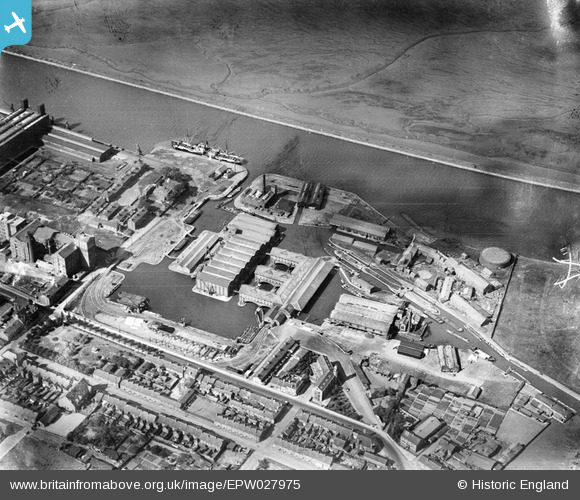
EPW027975 ENGLAND (1929). Canal port on the Manchester Ship Canal, Ellesmere Port, 1929
© Copyright OpenStreetMap contributors and licensed by the OpenStreetMap Foundation. 2025. Cartography is licensed as CC BY-SA.
Nearby Images (12)
Details
| Title | [EPW027975] Canal port on the Manchester Ship Canal, Ellesmere Port, 1929 |
| Reference | EPW027975 |
| Date | June-1929 |
| Link | |
| Place name | ELLESMERE PORT |
| Parish | |
| District | |
| Country | ENGLAND |
| Easting / Northing | 340527, 377302 |
| Longitude / Latitude | -2.8922632163781, 53.289068103584 |
| National Grid Reference | SJ405773 |
Pins
 Bill |
Saturday 20th of December 2014 04:04:04 AM | |
 MB |
Friday 31st of May 2013 10:15:10 AM | |
 MB |
Friday 31st of May 2013 10:14:10 AM | |
 MB |
Friday 31st of May 2013 10:13:24 AM | |
 MB |
Friday 31st of May 2013 10:12:40 AM | |
 Dylan Moore |
Tuesday 30th of October 2012 12:58:08 PM | |
 Dylan Moore |
Tuesday 30th of October 2012 12:57:42 PM |
User Comment Contributions
National Waterways Museum, Ellesmere Port, 18/07/2015 |
 Class31 |
Sunday 19th of July 2015 11:29:01 AM |


![[EPW027975] Canal port on the Manchester Ship Canal, Ellesmere Port, 1929](http://britainfromabove.org.uk/sites/all/libraries/aerofilms-images/public/100x100/EPW/027/EPW027975.jpg)
![[EPW027828] Telford's Quay and the Manchester Ship Canal, Ellesmere Port, 1929](http://britainfromabove.org.uk/sites/all/libraries/aerofilms-images/public/100x100/EPW/027/EPW027828.jpg)
![[EPW027826] Telford's Quay, Dock Street and the Manchester Ship Canal, Ellesmere Port, 1929. This image has been produced from a damaged negative.](http://britainfromabove.org.uk/sites/all/libraries/aerofilms-images/public/100x100/EPW/027/EPW027826.jpg)
![[EAW415732] Mount Manisty, Ellesmere Port, 1981](http://britainfromabove.org.uk/sites/all/libraries/aerofilms-images/public/100x100/EAW/415/EAW415732.jpg)
![[EAW043736] The Flour Mills on Lower Mersey Street, Ellesmere Port, 1952. This image was marked by Aerofilms Ltd for photo editing.](http://britainfromabove.org.uk/sites/all/libraries/aerofilms-images/public/100x100/EAW/043/EAW043736.jpg)
![[EAW043733] The Flour Mills on Lower Mersey Street, Ellesmere Port, 1952. This image was marked by Aerofilms Ltd for photo editing.](http://britainfromabove.org.uk/sites/all/libraries/aerofilms-images/public/100x100/EAW/043/EAW043733.jpg)
![[EAW043730] The Flour Mills on Lower Mersey Street, Ellesmere Port, 1952. This image was marked by Aerofilms Ltd for photo editing.](http://britainfromabove.org.uk/sites/all/libraries/aerofilms-images/public/100x100/EAW/043/EAW043730.jpg)
![[EAW043732] The Flour Mills on Lower Mersey Street, Ellesmere Port, 1952. This image was marked by Aerofilms Ltd for photo editing.](http://britainfromabove.org.uk/sites/all/libraries/aerofilms-images/public/100x100/EAW/043/EAW043732.jpg)
![[EAW043735] The Flour Mills on Lower Mersey Street, Ellesmere Port, 1952. This image was marked by Aerofilms Ltd for photo editing.](http://britainfromabove.org.uk/sites/all/libraries/aerofilms-images/public/100x100/EAW/043/EAW043735.jpg)
![[EAW043738] The Flour Mills on Lower Mersey Street, Ellesmere Port, 1952. This image was marked by Aerofilms Ltd for photo editing.](http://britainfromabove.org.uk/sites/all/libraries/aerofilms-images/public/100x100/EAW/043/EAW043738.jpg)
![[EPW014974] The town and Stanlow Banks, Ellesmere Port, 1926. This image has been produced from a copy-negative.](http://britainfromabove.org.uk/sites/all/libraries/aerofilms-images/public/100x100/EPW/014/EPW014974.jpg)
![[EAW043734] The Flour Mills on Lower Mersey Street, Ellesmere Port, 1952. This image was marked by Aerofilms Ltd for photo editing.](http://britainfromabove.org.uk/sites/all/libraries/aerofilms-images/public/100x100/EAW/043/EAW043734.jpg)