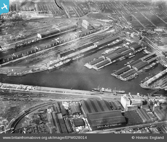
EPW028014 ENGLAND (1929). Salford Docks, Salford, 1929
© Copyright OpenStreetMap contributors and licensed by the OpenStreetMap Foundation. 2025. Cartography is licensed as CC BY-SA.
Nearby Images (13)
Details
| Title | [EPW028014] Salford Docks, Salford, 1929 |
| Reference | EPW028014 |
| Date | July-1929 |
| Link | |
| Place name | SALFORD |
| Parish | |
| District | |
| Country | ENGLAND |
| Easting / Northing | 380834, 397030 |
| Longitude / Latitude | -2.2887586217279, 53.469404331193 |
| National Grid Reference | SJ808970 |
Pins
 Crofter56 |
Sunday 28th of October 2012 06:45:55 PM |


![[EPW028014] Salford Docks, Salford, 1929](http://britainfromabove.org.uk/sites/all/libraries/aerofilms-images/public/100x100/EPW/028/EPW028014.jpg)
![[EAW006235] The Salford Docks and Manchester Ship Canal, Salford, 1947](http://britainfromabove.org.uk/sites/all/libraries/aerofilms-images/public/100x100/EAW/006/EAW006235.jpg)
![[EPW019157] Salford Docks, Salford, 1927](http://britainfromabove.org.uk/sites/all/libraries/aerofilms-images/public/100x100/EPW/019/EPW019157.jpg)
![[EAW050416] Manchester Docks, Salford, from the south, 1953](http://britainfromabove.org.uk/sites/all/libraries/aerofilms-images/public/100x100/EAW/050/EAW050416.jpg)
![[EAW006236] The Salford Docks and Manchester Ship Canal, Salford, 1947](http://britainfromabove.org.uk/sites/all/libraries/aerofilms-images/public/100x100/EAW/006/EAW006236.jpg)
![[EPW027860] The Salford Docks and the Manchester Ship Canal, Salford, 1929](http://britainfromabove.org.uk/sites/all/libraries/aerofilms-images/public/100x100/EPW/027/EPW027860.jpg)
![[EAW021935] Manchester Docks, Salford, 1949. This image has been produced from a print.](http://britainfromabove.org.uk/sites/all/libraries/aerofilms-images/public/100x100/EAW/021/EAW021935.jpg)
![[EAW050417] Manchester Docks, Salford, from the south-east, 1953](http://britainfromabove.org.uk/sites/all/libraries/aerofilms-images/public/100x100/EAW/050/EAW050417.jpg)
![[EPW027781] Railway sidings and warehouses at the Salford Docks, Salford, 1929](http://britainfromabove.org.uk/sites/all/libraries/aerofilms-images/public/100x100/EPW/027/EPW027781.jpg)
![[EPW055071] Salford Docks, Ordsall, 1937](http://britainfromabove.org.uk/sites/all/libraries/aerofilms-images/public/100x100/EPW/055/EPW055071.jpg)
![[EPW041685] The Salford Quays, Salford, 1933](http://britainfromabove.org.uk/sites/all/libraries/aerofilms-images/public/100x100/EPW/041/EPW041685.jpg)
![[EPW017596] No. 9 Dock, Salford Quays, 1927](http://britainfromabove.org.uk/sites/all/libraries/aerofilms-images/public/100x100/EPW/017/EPW017596.jpg)
![[EPW028015] No. 9 Dock at Salford Quays, Salford, 1929](http://britainfromabove.org.uk/sites/all/libraries/aerofilms-images/public/100x100/EPW/028/EPW028015.jpg)