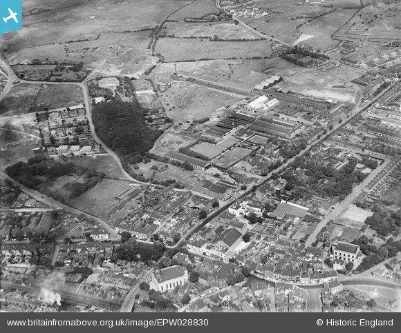
EPW028830 ENGLAND (1929). Mount Pleasant, Bilston, 1929
© Copyright OpenStreetMap contributors and licensed by the OpenStreetMap Foundation. 2024. Cartography is licensed as CC BY-SA.
Nearby Images (6)
Details
| Title | [EPW028830] Mount Pleasant, Bilston, 1929 |
| Reference | EPW028830 |
| Date | 30-August-1929 |
| Link | |
| Place name | BILSTON |
| Parish | |
| District | |
| Country | ENGLAND |
| Easting / Northing | 395102, 296784 |
| Longitude / Latitude | -2.0722728109499, 52.568500655966 |
| National Grid Reference | SO951968 |
Pins
 GaryGareth |
Wednesday 22nd of July 2020 01:12:46 PM | |
 GaryGareth |
Wednesday 22nd of July 2020 12:48:53 PM | |
 stourwolf |
Sunday 12th of July 2015 10:03:35 AM | |
 stourwolf |
Sunday 12th of July 2015 10:03:35 AM | |
 stourwolf |
Sunday 12th of July 2015 10:03:30 AM | |
 dbm |
Tuesday 6th of January 2015 04:33:48 PM | |
 Bentleyboy |
Monday 7th of April 2014 09:12:00 AM | |
 Bentleyboy |
Monday 7th of April 2014 09:10:20 AM | |
 Bentleyboy |
Monday 7th of April 2014 09:08:02 AM | |
 garygareth |
Thursday 21st of March 2013 05:30:00 PM | |
 MetalMike |
Sunday 3rd of February 2013 08:57:25 PM | |
 MetalMike |
Sunday 3rd of February 2013 08:42:01 PM | |
 MetalMike |
Sunday 3rd of February 2013 08:37:14 PM | |
 MetalMike |
Sunday 3rd of February 2013 08:35:30 PM | |
 wulfrunian |
Friday 14th of December 2012 11:01:32 AM | |
 wulfrunian |
Friday 14th of December 2012 10:42:37 AM | |
 wulfrunian |
Friday 14th of December 2012 10:39:51 AM | |
 wulfrunian |
Friday 14th of December 2012 10:37:15 AM | |
sorry, but Newbolt was born in St Marys Vicarage in Bath Street. |
 Bilstonia |
Friday 14th of December 2012 09:09:36 PM |
 wulfrunian |
Friday 14th of December 2012 10:32:02 AM | |
The Georgian house was once home to the Police Superintendant. The Globe Hotel stood on the other side. So the car park was where the house stood, |
 Bilstonia |
Friday 14th of December 2012 07:29:57 PM |
 wulfrunian |
Friday 14th of December 2012 10:29:18 AM | |
 wulfrunian |
Friday 14th of December 2012 10:25:15 AM | |
 wulfrunian |
Friday 14th of December 2012 10:20:49 AM | |
 wulfrunian |
Friday 14th of December 2012 10:12:30 AM | |
Its a great pity that this building has left to decay, it would make a fine museum for Bilstons great historic memorabila/artifacts. |
 Bilstonia |
Friday 14th of December 2012 07:17:21 PM |
 wulfrunian |
Thursday 13th of December 2012 07:18:52 PM | |
 wulfrunian |
Thursday 13th of December 2012 07:16:33 PM | |
'The Woodlands' would make a fine library. |
 Bilstonia |
Friday 14th of December 2012 07:06:52 PM |
 wulfrunian |
Thursday 13th of December 2012 07:14:17 PM | |
 wulfrunian |
Thursday 13th of December 2012 07:13:13 PM | |
 wulfrunian |
Thursday 13th of December 2012 07:11:46 PM | |
 wulfrunian |
Thursday 13th of December 2012 07:05:04 PM | |
 wulfrunian |
Thursday 13th of December 2012 06:56:55 PM | |
 wulfrunian |
Thursday 13th of December 2012 12:29:34 PM | |
 wulfrunian |
Thursday 13th of December 2012 12:26:12 PM | |
 wulfrunian |
Thursday 13th of December 2012 12:22:52 PM | |
My husbands great grandfather was John Fellows, following through Joseph and then Frederick. We have been tracing Fellows Factories for some time . Does anyone happen to know Gun Barrel Works also owned by Fellows |
 Fred |
Saturday 18th of February 2017 02:57:04 PM |
 wulfrunian |
Thursday 13th of December 2012 12:19:39 PM | |
 wulfrunian |
Thursday 13th of December 2012 12:15:26 PM | |
 wulfrunian |
Thursday 13th of December 2012 12:14:35 PM | |
 wulfrunian |
Thursday 13th of December 2012 12:14:08 PM | |
 wulfrunian |
Thursday 13th of December 2012 12:12:08 PM | |
 wulfrunian |
Thursday 13th of December 2012 12:11:16 PM | |
 wulfrunian |
Thursday 13th of December 2012 12:09:39 PM | |
 wulfrunian |
Thursday 13th of December 2012 12:07:21 PM | |
 wulfrunian |
Thursday 13th of December 2012 12:06:10 PM |
User Comment Contributions
My great grandfather was the landlord of The Globe Inn Bilston and died there in 1883. Anyone got any photographs? |
 Maritime46 |
Thursday 20th of October 2016 02:33:34 PM |
its a pity the pins dont have numbers, it would be easier to identify buildings. |
 Bilstonia |
Friday 14th of December 2012 09:12:00 PM |
View of Bilston, looking roughly south to north. St. Leonard's church, the traditional centre of the town, is at centre bottom. Most of Bilston's extensive industries are to the south and west of this picture, as is most of the working class housing. The fields at the top were once part of Bilston's open fields, later enclosed - and then covered in mining, moslty in the from of bell pits. At the time of the picture they are still being developed for housing, which now covers every field. |
 wulfrunian |
Thursday 13th of December 2012 06:53:50 PM |


![[EPW028830] Mount Pleasant, Bilston, 1929](http://britainfromabove.org.uk/sites/all/libraries/aerofilms-images/public/100x100/EPW/028/EPW028830.jpg)
![[EPW028827] The Albion Works and environs, Bilston, 1929](http://britainfromabove.org.uk/sites/all/libraries/aerofilms-images/public/100x100/EPW/028/EPW028827.jpg)
![[EPW028828] The Albion Works and environs, Bilston, 1929](http://britainfromabove.org.uk/sites/all/libraries/aerofilms-images/public/100x100/EPW/028/EPW028828.jpg)
![[EPW028825] The Albion Works and environs, Bilston, 1929](http://britainfromabove.org.uk/sites/all/libraries/aerofilms-images/public/100x100/EPW/028/EPW028825.jpg)
![[EPW028824] The Albion Works, Etruria Works and environs, Bilston, 1929](http://britainfromabove.org.uk/sites/all/libraries/aerofilms-images/public/100x100/EPW/028/EPW028824.jpg)
![[EPW028829] The Albion Works, Etruria Works and environs, Bilston, 1929](http://britainfromabove.org.uk/sites/all/libraries/aerofilms-images/public/100x100/EPW/028/EPW028829.jpg)