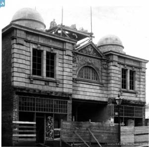
EPW029252 ENGLAND (1929). The town centre, Cockermouth, 1929
© Copyright OpenStreetMap contributors and licensed by the OpenStreetMap Foundation. 2024. Cartography is licensed as CC BY-SA.
Nearby Images (6)
Details
| Title | [EPW029252] The town centre, Cockermouth, 1929 |
| Reference | EPW029252 |
| Date | September-1929 |
| Link | |
| Place name | COCKERMOUTH |
| Parish | COCKERMOUTH |
| District | |
| Country | ENGLAND |
| Easting / Northing | 312088, 530587 |
| Longitude / Latitude | -3.3630615681423, 54.662576877324 |
| National Grid Reference | NY121306 |
Pins
 mapmaker |
Tuesday 7th of July 2015 11:04:47 PM | |
 Brian |
Thursday 21st of August 2014 04:13:52 PM | |
 Brian |
Thursday 21st of August 2014 04:13:14 PM | |
 Brian |
Thursday 21st of August 2014 04:11:42 PM | |
 Brian |
Thursday 21st of August 2014 04:10:37 PM | |
 Brian |
Thursday 21st of August 2014 04:04:29 PM | |
Robert Tims |
Thursday 17th of January 2013 04:35:13 PM |
User Comment Contributions
 Borders Project |
Tuesday 26th of August 2014 10:57:46 AM |


![[EPW029252] The town centre, Cockermouth, 1929](http://britainfromabove.org.uk/sites/all/libraries/aerofilms-images/public/100x100/EPW/029/EPW029252.jpg)
![[EPW029257] The Clock Tower and Main Street, Cockermouth, 1929](http://britainfromabove.org.uk/sites/all/libraries/aerofilms-images/public/100x100/EPW/029/EPW029257.jpg)
![[EPW029259] Main Street, Cockermouth, 1929](http://britainfromabove.org.uk/sites/all/libraries/aerofilms-images/public/100x100/EPW/029/EPW029259.jpg)
![[EPW029250] Cockermouth Castle and the town, Cockermouth, 1929](http://britainfromabove.org.uk/sites/all/libraries/aerofilms-images/public/100x100/EPW/029/EPW029250.jpg)
![[EPW029254] The Market Place and Cockermouth Castle, Cockermouth, 1929](http://britainfromabove.org.uk/sites/all/libraries/aerofilms-images/public/100x100/EPW/029/EPW029254.jpg)
![[EPW029260] Cockermouth Castle and the town, Cockermouth, 1929](http://britainfromabove.org.uk/sites/all/libraries/aerofilms-images/public/100x100/EPW/029/EPW029260.jpg)

