
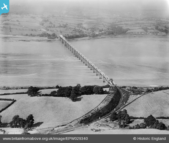
EPW029340 ENGLAND (1929). The Severn Railway Bridge, Sharpness, 1929
© Copyright OpenStreetMap contributors and licensed by the OpenStreetMap Foundation. 2025. Cartography is licensed as CC BY-SA.
Nearby Images (2)
EPW029340

EAW006848

Details
| Title | [EPW029340] The Severn Railway Bridge, Sharpness, 1929 |
| Reference | EPW029340 |
| Date | September-1929 |
| Link | |
| Place name | SHARPNESS |
| Parish | HINTON |
| District | |
| Country | ENGLAND |
| Easting / Northing | 367552, 203601 |
| Longitude / Latitude | -2.4698768413374, 51.729727323339 |
| National Grid Reference | SO676036 |
Pins
 gerry-r |
Sunday 22nd of June 2014 02:20:59 AM | |
MB |
Monday 22nd of October 2012 11:46:55 AM | |
MB |
Monday 22nd of October 2012 11:45:44 AM | |
Didn't the railway run beneath the (now demolished) brick viaduct? |
Isleworth1961 |
Monday 22nd of October 2012 11:06:08 PM |
Gloucester-South Wales line hugs the river bank at this point. |
gerry-r |
Sunday 22nd of June 2014 02:15:09 AM |
MB |
Monday 22nd of October 2012 11:45:15 AM | |
This is a hedge line. The main line runs below the stone arches of the approach viaduct and follows the river bank here. |
gerry-r |
Sunday 22nd of June 2014 02:24:26 AM |
MB |
Monday 22nd of October 2012 11:44:01 AM | |
MB |
Monday 22nd of October 2012 11:42:58 AM | |
Curiously the swinging span was built for, but never laid with, double track although the rest of the bridge and approach lines were single. |
gerry-r |
Sunday 22nd of June 2014 02:28:34 AM |
User Comment Contributions
The bridge or viaduct lasted in use for 90 years. It was built in 1870. On 25 October 1960 it was hit by two petroleum barges and two spans collapsed. Further damage followed in 1961 and the Severn Railway Bridge was subsequently demolished. The pier for the centre of the swing bridge over the canal survives. The bridge provided a diversionary route for trains when the Severn Tunnel was closed for maintenance work |
MB |
Sunday 22nd of June 2014 01:35:31 AM |
Not exactly. The foundation stone was laid in 1875 & the bridge opened to traffic in 1879. While it did serve as an alternative route for some Bristol-S.Wales trains when the tunnel was closed, typically on winter Sundays, this was never its primary purpose and the structure was too lightly built to accommodate the heaviest loadings. Strengthening work was actually being carried out when the disaster happened and with the closure of the lines into the Forest of Dean in the 1960s this would have been its sole purpose. |
gerry-r |
Sunday 22nd of June 2014 01:35:31 AM |