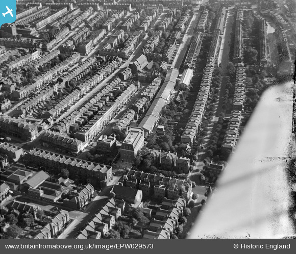
EPW029573 ENGLAND (1929). The Brilliant Sign Co Paragon Works and environs, Shepherd's Bush, 1929
© Copyright OpenStreetMap contributors and licensed by the OpenStreetMap Foundation. 2025. Cartography is licensed as CC BY-SA.
Nearby Images (9)
Details
| Title | [EPW029573] The Brilliant Sign Co Paragon Works and environs, Shepherd's Bush, 1929 |
| Reference | EPW029573 |
| Date | September-1929 |
| Link | |
| Place name | SHEPHERD'S BUSH |
| Parish | |
| District | |
| Country | ENGLAND |
| Easting / Northing | 522643, 180013 |
| Longitude / Latitude | -0.23269895872554, 51.505241607972 |
| National Grid Reference | TQ226800 |
Pins
User Comment Contributions
View looking south. |
 Class31 |
Wednesday 19th of March 2014 08:57:52 AM |


![[EPW029573] The Brilliant Sign Co Paragon Works and environs, Shepherd's Bush, 1929](http://britainfromabove.org.uk/sites/all/libraries/aerofilms-images/public/100x100/EPW/029/EPW029573.jpg)
![[EPW029574] Uxbridge Road and environs, Shepherd's Bush, 1929](http://britainfromabove.org.uk/sites/all/libraries/aerofilms-images/public/100x100/EPW/029/EPW029574.jpg)
![[EPW029572] The Brilliant Sign Co Paragon Works and environs, Shepherd's Bush, 1929](http://britainfromabove.org.uk/sites/all/libraries/aerofilms-images/public/100x100/EPW/029/EPW029572.jpg)
![[EPW029578] The Brilliant Sign Co Paragon Works and environs, Shepherd's Bush, 1929](http://britainfromabove.org.uk/sites/all/libraries/aerofilms-images/public/100x100/EPW/029/EPW029578.jpg)
![[EPW029579] The Brilliant Sign Co Paragon Works and environs, Shepherd's Bush, 1929](http://britainfromabove.org.uk/sites/all/libraries/aerofilms-images/public/100x100/EPW/029/EPW029579.jpg)
![[EPW029571] Uxbridge Road and environs, Shepherd's Bush, 1929](http://britainfromabove.org.uk/sites/all/libraries/aerofilms-images/public/100x100/EPW/029/EPW029571.jpg)
![[EPW029576] The Brilliant Sign Co Paragon Works and environs, Shepherd's Bush, 1929](http://britainfromabove.org.uk/sites/all/libraries/aerofilms-images/public/100x100/EPW/029/EPW029576.jpg)
![[EPW029575] Uxbridge Road and the Brilliant Sign Co Paragon Works, Shepherd's Bush, 1929](http://britainfromabove.org.uk/sites/all/libraries/aerofilms-images/public/100x100/EPW/029/EPW029575.jpg)
![[EPW029577] The Brilliant Sign Co Paragon Works and environs, Shepherd's Bush, 1929](http://britainfromabove.org.uk/sites/all/libraries/aerofilms-images/public/100x100/EPW/029/EPW029577.jpg)