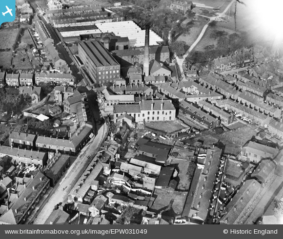
EPW031049 ENGLAND (1929). Market Street, Hollins Cotton Mill and environs, Marple, 1929
© Copyright OpenStreetMap contributors and licensed by the OpenStreetMap Foundation. 2025. Cartography is licensed as CC BY-SA.
Details
| Title | [EPW031049] Market Street, Hollins Cotton Mill and environs, Marple, 1929 |
| Reference | EPW031049 |
| Date | October-1929 |
| Link | |
| Place name | MARPLE |
| Parish | |
| District | |
| Country | ENGLAND |
| Easting / Northing | 395897, 388572 |
| Longitude / Latitude | -2.0617067690649, 53.393703515312 |
| National Grid Reference | SJ959886 |
Pins
 buryblackpud |
Friday 16th of February 2024 04:10:12 PM | |
 John Ellis |
Friday 13th of September 2013 08:43:22 PM | |
 John Ellis |
Friday 13th of September 2013 08:42:13 PM | |
 John Ellis |
Friday 13th of September 2013 08:41:47 PM | |
 John Ellis |
Friday 13th of September 2013 08:41:19 PM | |
 John Ellis |
Friday 13th of September 2013 08:40:31 PM |


![[EPW031049] Market Street, Hollins Cotton Mill and environs, Marple, 1929](http://britainfromabove.org.uk/sites/all/libraries/aerofilms-images/public/100x100/EPW/031/EPW031049.jpg)
![[EPW031050] Hollins Cotton Mill and Memorial Park, Marple, 1929. This image has been produced from a copy-negative.](http://britainfromabove.org.uk/sites/all/libraries/aerofilms-images/public/100x100/EPW/031/EPW031050.jpg)
![[EPW031046] Church Street and environs, Marple, 1929](http://britainfromabove.org.uk/sites/all/libraries/aerofilms-images/public/100x100/EPW/031/EPW031046.jpg)
![[EPW031048] Hollins Cotton Mill and the Memorial Park, Marple, 1929](http://britainfromabove.org.uk/sites/all/libraries/aerofilms-images/public/100x100/EPW/031/EPW031048.jpg)