
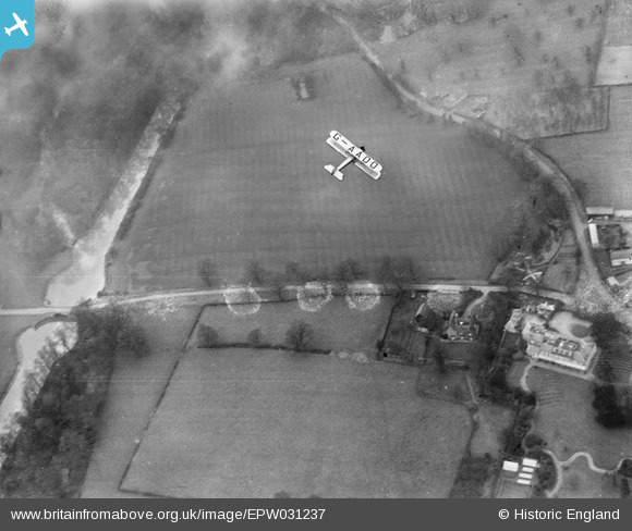
EPW031237 ENGLAND (1930). The Gloster Survey Aeroplane flying near the Heston Air Park, Cranford, 1930. This image has been produced from a damaged negative.
© Copyright OpenStreetMap contributors and licensed by the OpenStreetMap Foundation. 2025. Cartography is licensed as CC BY-SA.
Nearby Images (3)
EPW031237

EPW061095

EPW060379

Details
| Title | [EPW031237] The Gloster Survey Aeroplane flying near the Heston Air Park, Cranford, 1930. This image has been produced from a damaged negative. |
| Reference | EPW031237 |
| Date | 25-January-1930 |
| Link | |
| Place name | CRANFORD |
| Parish | |
| District | |
| Country | ENGLAND |
| Easting / Northing | 510464, 178147 |
| Longitude / Latitude | -0.40870738856447, 51.490980499695 |
| National Grid Reference | TQ105781 |
Pins
 Martin Devlin |
Sunday 3rd of October 2021 10:20:03 PM | |
Martin Devlin |
Sunday 3rd of October 2021 10:16:57 PM | |
Martin Devlin |
Sunday 3rd of October 2021 10:14:22 PM | |
Martin Devlin |
Sunday 3rd of October 2021 10:22:38 AM | |
 daviddb |
Monday 3rd of December 2012 05:27:17 PM | |
 Class31 |
Monday 22nd of October 2012 11:33:17 AM | |
Class31 |
Monday 22nd of October 2012 11:32:49 AM | |
 Dylan Moore |
Sunday 21st of October 2012 11:39:40 PM | |
Dylan Thank you for all of your comments you certainly know your stuff |
southallboy |
Wednesday 12th of June 2013 10:22:13 AM |
Dylan Moore |
Sunday 21st of October 2012 11:38:43 PM | |
Dylan Moore |
Sunday 21st of October 2012 11:38:20 PM | |
Dylan Moore |
Sunday 21st of October 2012 11:34:46 PM | |
Dylan Moore |
Sunday 21st of October 2012 11:34:26 PM | |
Dylan Moore |
Sunday 21st of October 2012 11:31:50 PM | |
Dylan Moore |
Sunday 21st of October 2012 11:30:48 PM | |
Dylan Moore |
Sunday 21st of October 2012 11:28:47 PM |
User Comment Contributions
Thank you! Although the main subject of the image is really the aircraft, it's good to be able to put a pin on the map for people who are more interested in what this area looked like before it was covered by Junction 3... We'll update the catalogue, and post the correct location data here in due course. Great job. Yours, Katy Britain from Above Cataloguing Team Leader |
Katy Whitaker |
Wednesday 24th of October 2012 12:42:02 PM |
View looking north. This view today is absolutely dominated by the M4 which crosses the shot below the aircraft and Junction 3 complete with it's slip roads. |
Class31 |
Monday 22nd of October 2012 11:39:40 AM |