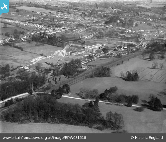
EPW031516 ENGLAND (1930). The Apsley Paper Mills and Apsley End, Apsley, 1930
© Copyright OpenStreetMap contributors and licensed by the OpenStreetMap Foundation. 2025. Cartography is licensed as CC BY-SA.
Nearby Images (33)
Details
| Title | [EPW031516] The Apsley Paper Mills and Apsley End, Apsley, 1930 |
| Reference | EPW031516 |
| Date | February-1930 |
| Link | |
| Place name | APSLEY |
| Parish | |
| District | |
| Country | ENGLAND |
| Easting / Northing | 506357, 204797 |
| Longitude / Latitude | -0.45975954153951, 51.731327668794 |
| National Grid Reference | TL064048 |
Pins
 ordinarybloke |
Sunday 7th of April 2013 10:29:57 AM | |
 ordinarybloke |
Sunday 7th of April 2013 10:28:59 AM |


![[EPW031516] The Apsley Paper Mills and Apsley End, Apsley, 1930](http://britainfromabove.org.uk/sites/all/libraries/aerofilms-images/public/100x100/EPW/031/EPW031516.jpg)
![[EPW031518] The Apsley Paper Mills, Apsley, 1930](http://britainfromabove.org.uk/sites/all/libraries/aerofilms-images/public/100x100/EPW/031/EPW031518.jpg)
![[EPW060989] John Dickinson and Co Paper Mills, Apsley, from the south-east, 1939](http://britainfromabove.org.uk/sites/all/libraries/aerofilms-images/public/100x100/EPW/060/EPW060989.jpg)
![[EPW060990] John Dickinson and Co Paper Mills, Apsley, 1939](http://britainfromabove.org.uk/sites/all/libraries/aerofilms-images/public/100x100/EPW/060/EPW060990.jpg)
![[EAW022321] John Dickinson and Co Apsley Paper Mills, Apsley Railway Station and environs, Apsley, from the south-east, 1949](http://britainfromabove.org.uk/sites/all/libraries/aerofilms-images/public/100x100/EAW/022/EAW022321.jpg)
![[EAW022315] John Dickinson and Co Apsley Paper Mills and Apsley Railway Station, Apsley, from the south-east, 1949](http://britainfromabove.org.uk/sites/all/libraries/aerofilms-images/public/100x100/EAW/022/EAW022315.jpg)
![[EPW060991] John Dickinson and Co Paper Mills, Apsley, 1939](http://britainfromabove.org.uk/sites/all/libraries/aerofilms-images/public/100x100/EPW/060/EPW060991.jpg)
![[EAW022317] John Dickinson and Co Apsley Paper Mills, the Grand Union Canal and environs, Apsley, 1949. This image was marked by Aerofilms Ltd for photo editing.](http://britainfromabove.org.uk/sites/all/libraries/aerofilms-images/public/100x100/EAW/022/EAW022317.jpg)
![[EAW022324] John Dickinson and Co Apsley Paper Mills, Apsley Railway Station and environs, Apsley, from the south-east, 1949](http://britainfromabove.org.uk/sites/all/libraries/aerofilms-images/public/100x100/EAW/022/EAW022324.jpg)
![[EPW031460] The Apsley Paper Mills and surroundings, Rucklers Lane, 1930](http://britainfromabove.org.uk/sites/all/libraries/aerofilms-images/public/100x100/EPW/031/EPW031460.jpg)
![[EPW015684] The Apsley Paper Mills, London to Birmingham Railway line and Grand Union Canal, Apsley, 1926](http://britainfromabove.org.uk/sites/all/libraries/aerofilms-images/public/100x100/EPW/015/EPW015684.jpg)
![[EAW022319] John Dickinson and Co Apsley Paper Mills and London Road, Apsley, from the south-east, 1949. This image was marked by Aerofilms Ltd for photo editing.](http://britainfromabove.org.uk/sites/all/libraries/aerofilms-images/public/100x100/EAW/022/EAW022319.jpg)
![[EPW031521] The Apsley Paper Mills and Mill House, Apsley, 1930](http://britainfromabove.org.uk/sites/all/libraries/aerofilms-images/public/100x100/EPW/031/EPW031521.jpg)
![[EPW015685] The Apsley Paper Mills and the Grand Union Canal, Apsley, 1926](http://britainfromabove.org.uk/sites/all/libraries/aerofilms-images/public/100x100/EPW/015/EPW015685.jpg)
![[EPW031520] The Apsley Paper Mills, Apsley, 1930](http://britainfromabove.org.uk/sites/all/libraries/aerofilms-images/public/100x100/EPW/031/EPW031520.jpg)
![[EPW048253] The Apsley Paper Mills, St Mary's Church and surrounding countryside, Apsley, 1935](http://britainfromabove.org.uk/sites/all/libraries/aerofilms-images/public/100x100/EPW/048/EPW048253.jpg)
![[EPW001247] John Dickinsons Paper Mill, Apsley, 1920](http://britainfromabove.org.uk/sites/all/libraries/aerofilms-images/public/100x100/EPW/001/EPW001247.jpg)
![[EPW031598] John Dickinson and Co Paper Mills, Apsley, 1930](http://britainfromabove.org.uk/sites/all/libraries/aerofilms-images/public/100x100/EPW/031/EPW031598.jpg)
![[EPW015683] The Apsley Paper Mills and London to Birmingham Railway line, Apsley, 1926](http://britainfromabove.org.uk/sites/all/libraries/aerofilms-images/public/100x100/EPW/015/EPW015683.jpg)
![[EAW022325] John Dickinson and Co Apsley Paper Mills and environs, Apsley, 1949. This image was marked by Aerofilms Ltd for photo editing.](http://britainfromabove.org.uk/sites/all/libraries/aerofilms-images/public/100x100/EAW/022/EAW022325.jpg)
![[EPW015689] The Apsley Paper Mills, Apsley, 1926](http://britainfromabove.org.uk/sites/all/libraries/aerofilms-images/public/100x100/EPW/015/EPW015689.jpg)
![[EPW015688] The Apsley Paper Mills, Apsley, 1926](http://britainfromabove.org.uk/sites/all/libraries/aerofilms-images/public/100x100/EPW/015/EPW015688.jpg)
![[EPW048262] The Apsley Paper Mills and the surrounding residential area, Apsley, 1935](http://britainfromabove.org.uk/sites/all/libraries/aerofilms-images/public/100x100/EPW/048/EPW048262.jpg)
![[EPW031461] The Apsley Paper Mills, Apsley, 1930](http://britainfromabove.org.uk/sites/all/libraries/aerofilms-images/public/100x100/EPW/031/EPW031461.jpg)
![[EPW048251] The Apsley Paper Mills, St Mary's Church and surrounding countryside, Apsley, 1935](http://britainfromabove.org.uk/sites/all/libraries/aerofilms-images/public/100x100/EPW/048/EPW048251.jpg)
![[EPW060992] John Dickinson and Co Paper Mills, Apsley, 1939](http://britainfromabove.org.uk/sites/all/libraries/aerofilms-images/public/100x100/EPW/060/EPW060992.jpg)
![[EPW031519] The Apsley Paper Mills and St Mary's Church, Apsley, from the east, 1930](http://britainfromabove.org.uk/sites/all/libraries/aerofilms-images/public/100x100/EPW/031/EPW031519.jpg)
![[EPW031458] The Apsley Paper Mills, Apsley, 1930](http://britainfromabove.org.uk/sites/all/libraries/aerofilms-images/public/100x100/EPW/031/EPW031458.jpg)
![[EPW048254] The Apsley Paper Mills and surrounding countryside, Apsley, 1935](http://britainfromabove.org.uk/sites/all/libraries/aerofilms-images/public/100x100/EPW/048/EPW048254.jpg)
![[EPW031604] John Dickinson and Co Paper Mills, Apsley, 1930](http://britainfromabove.org.uk/sites/all/libraries/aerofilms-images/public/100x100/EPW/031/EPW031604.jpg)
![[EPW016003] St Mary's Church and the Apsley Paper Mills, Apsley, 1926](http://britainfromabove.org.uk/sites/all/libraries/aerofilms-images/public/100x100/EPW/016/EPW016003.jpg)
![[EPW031597] John Dickinson and Co Paper Mills, Apsley, 1930](http://britainfromabove.org.uk/sites/all/libraries/aerofilms-images/public/100x100/EPW/031/EPW031597.jpg)
![[EPW046725] St Mary's Church, John Dickinson & Co. Paper Mills and environs, Apsley, 1935](http://britainfromabove.org.uk/sites/all/libraries/aerofilms-images/public/100x100/EPW/046/EPW046725.jpg)