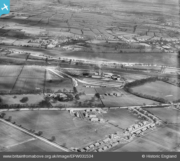
EPW031534 ENGLAND (1930). The Poppleton Sugar Beet Factory, Clifton Ings and surroundings, York, 1930
© Copyright OpenStreetMap contributors and licensed by the OpenStreetMap Foundation. 2025. Cartography is licensed as CC BY-SA.
Nearby Images (12)
Details
| Title | [EPW031534] The Poppleton Sugar Beet Factory, Clifton Ings and surroundings, York, 1930 |
| Reference | EPW031534 |
| Date | February-1930 |
| Link | |
| Place name | YORK |
| Parish | |
| District | |
| Country | ENGLAND |
| Easting / Northing | 457615, 453029 |
| Longitude / Latitude | -1.1215841510581, 53.969924773275 |
| National Grid Reference | SE576530 |
Pins
 YorkStories |
Saturday 30th of June 2012 10:31:07 PM |
User Comment Contributions
 YorkStories |
Saturday 30th of June 2012 10:39:29 PM | |
The image includes a good view of the grounds of the old North Riding asylum (which most of us knew by its later (post-1948?) name - Clifton Hospital. Since demolished, though the chapel (marked) and other peripheral buildings remain. |
 YorkStories |
Saturday 30th of June 2012 10:37:14 PM |


![[EPW031534] The Poppleton Sugar Beet Factory, Clifton Ings and surroundings, York, 1930](http://britainfromabove.org.uk/sites/all/libraries/aerofilms-images/public/100x100/EPW/031/EPW031534.jpg)
![[EPW031530A] The Poppleton Sugar Beet Factory and surrounding countryside, York, 1930](http://britainfromabove.org.uk/sites/all/libraries/aerofilms-images/public/100x100/EPW/031/EPW031530A.jpg)
![[EPW031531] The Poppleton Sugar Beet Factory and surrounding countryside, York, 1930](http://britainfromabove.org.uk/sites/all/libraries/aerofilms-images/public/100x100/EPW/031/EPW031531.jpg)
![[EPW031537] The Poppleton Sugar Beet Factory, Clifton Ings and surroundings, York, 1930](http://britainfromabove.org.uk/sites/all/libraries/aerofilms-images/public/100x100/EPW/031/EPW031537.jpg)
![[EPW031535] The Poppleton Sugar Beet Factory, Clifton Ings and surroundings, York, 1930](http://britainfromabove.org.uk/sites/all/libraries/aerofilms-images/public/100x100/EPW/031/EPW031535.jpg)
![[EPW031536] The Poppleton Sugar Beet Factory, Clifton Ings and surroundings, York, 1930. This image has been affected by flare.](http://britainfromabove.org.uk/sites/all/libraries/aerofilms-images/public/100x100/EPW/031/EPW031536.jpg)
![[EPW031538] The Poppleton Sugar Beet Factory, Clifton Ings and surroundings, York, 1930](http://britainfromabove.org.uk/sites/all/libraries/aerofilms-images/public/100x100/EPW/031/EPW031538.jpg)
![[EPW031533] The Poppleton Sugar Beet Factory, Clifton Ings and the North Riding of Yorkshire Psychiatric Hospital, York, 1930](http://britainfromabove.org.uk/sites/all/libraries/aerofilms-images/public/100x100/EPW/031/EPW031533.jpg)
![[EPW031532] The Poppleton Sugar Beet Factory and Acomb Park, York, 1930](http://britainfromabove.org.uk/sites/all/libraries/aerofilms-images/public/100x100/EPW/031/EPW031532.jpg)
![[EPW023549] The Poppleton Sugar Beet Factory, York, 1928](http://britainfromabove.org.uk/sites/all/libraries/aerofilms-images/public/100x100/EPW/023/EPW023549.jpg)
![[EPW023548] The Poppleton Sugar Beet Factory, York, 1928](http://britainfromabove.org.uk/sites/all/libraries/aerofilms-images/public/100x100/EPW/023/EPW023548.jpg)
![[EPW023550] The Poppleton Sugar Beet Factory, York, 1928](http://britainfromabove.org.uk/sites/all/libraries/aerofilms-images/public/100x100/EPW/023/EPW023550.jpg)
