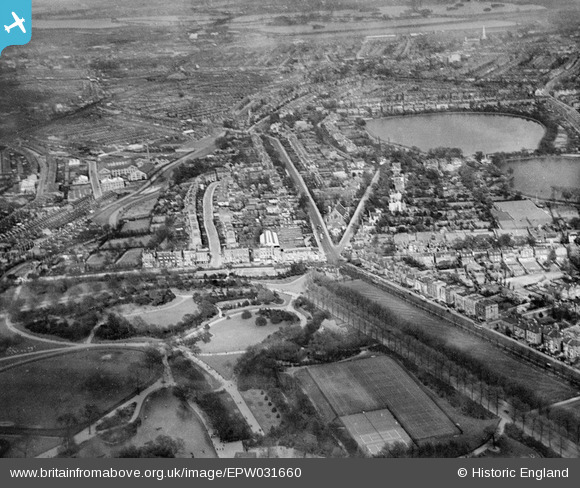
EPW031660 ENGLAND (1930). Finsbury Park and Seven Sisters Road, Finsbury Park, from the south-west, 1930
© Copyright OpenStreetMap contributors and licensed by the OpenStreetMap Foundation. 2025. Cartography is licensed as CC BY-SA.
Nearby Images (7)
Details
| Title | [EPW031660] Finsbury Park and Seven Sisters Road, Finsbury Park, from the south-west, 1930 |
| Reference | EPW031660 |
| Date | April-1930 |
| Link | |
| Place name | FINSBURY PARK |
| Parish | |
| District | |
| Country | ENGLAND |
| Easting / Northing | 531874, 187445 |
| Longitude / Latitude | -0.096970533913595, 51.569957689918 |
| National Grid Reference | TQ319874 |
Pins
 Colin |
Thursday 1st of August 2024 01:37:16 PM | |
 billyfern |
Monday 30th of June 2014 12:15:28 AM | |
 billyfern |
Monday 30th of June 2014 12:14:53 AM | |
 billyfern |
Monday 30th of June 2014 12:14:28 AM | |
 billyfern |
Monday 30th of June 2014 12:13:34 AM | |
 billyfern |
Monday 30th of June 2014 12:13:06 AM | |
 billyfern |
Monday 30th of June 2014 12:12:35 AM | |
 billyfern |
Monday 30th of June 2014 12:12:04 AM | |
 billyfern |
Monday 30th of June 2014 12:11:48 AM | |
 billyfern |
Monday 30th of June 2014 12:11:32 AM | |
 billyfern |
Monday 30th of June 2014 12:11:13 AM |


![[EPW031660] Finsbury Park and Seven Sisters Road, Finsbury Park, from the south-west, 1930](http://britainfromabove.org.uk/sites/all/libraries/aerofilms-images/public/100x100/EPW/031/EPW031660.jpg)
![[EPW031663] Finsbury Park and Seven Sisters Road, Finsbury Park, from the south-west, 1930](http://britainfromabove.org.uk/sites/all/libraries/aerofilms-images/public/100x100/EPW/031/EPW031663.jpg)
![[EPW031504] Finsbury Park, Woodberry Grove and Harringay Stadium, Finsbury Park, from the south-west, 1930](http://britainfromabove.org.uk/sites/all/libraries/aerofilms-images/public/100x100/EPW/031/EPW031504.jpg)
![[EPW031501] Finsbury Park, Woodberry Grove and environs, Finsbury Park, from the south-west, 1930](http://britainfromabove.org.uk/sites/all/libraries/aerofilms-images/public/100x100/EPW/031/EPW031501.jpg)
![[EPW031664] Finsbury Park and the East and West Reservoirs, Finsbury Park, from the north-west, 1930](http://britainfromabove.org.uk/sites/all/libraries/aerofilms-images/public/100x100/EPW/031/EPW031664.jpg)
![[EPW031665] Finsbury Park and Seven Sisters Road, Finsbury Park, from the south-west, 1930](http://britainfromabove.org.uk/sites/all/libraries/aerofilms-images/public/100x100/EPW/031/EPW031665.jpg)
![[EAW044323] Portland Rise, Green Lane, the new Woodberry Down Health Centre and environs, Stamford Hill, 1952](http://britainfromabove.org.uk/sites/all/libraries/aerofilms-images/public/100x100/EAW/044/EAW044323.jpg)