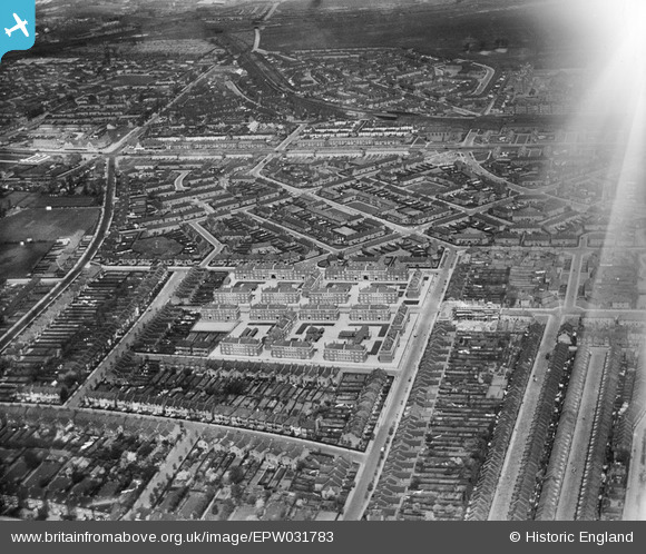
EPW031783 ENGLAND (1930). The Cleverly Estate, Shepherd's Bush, from the south-east, 1930
© Copyright OpenStreetMap contributors and licensed by the OpenStreetMap Foundation. 2025. Cartography is licensed as CC BY-SA.
Nearby Images (5)
Details
| Title | [EPW031783] The Cleverly Estate, Shepherd's Bush, from the south-east, 1930 |
| Reference | EPW031783 |
| Date | April-1930 |
| Link | |
| Place name | SHEPHERD'S BUSH |
| Parish | |
| District | |
| Country | ENGLAND |
| Easting / Northing | 522127, 180333 |
| Longitude / Latitude | -0.24001996036335, 51.508229614667 |
| National Grid Reference | TQ221803 |


![[EPW031783] The Cleverly Estate, Shepherd's Bush, from the south-east, 1930](http://britainfromabove.org.uk/sites/all/libraries/aerofilms-images/public/100x100/EPW/031/EPW031783.jpg)
![[EPW031782] The Cleverly Estate, Shepherd's Bush, from the south-east, 1930](http://britainfromabove.org.uk/sites/all/libraries/aerofilms-images/public/100x100/EPW/031/EPW031782.jpg)
![[EPW031781] The Cleverly Estate, Shepherd's Bush, from the south-east, 1930](http://britainfromabove.org.uk/sites/all/libraries/aerofilms-images/public/100x100/EPW/031/EPW031781.jpg)
![[EPW031780] The Cleverly Estate, Shepherd's Bush, from the south-east, 1930](http://britainfromabove.org.uk/sites/all/libraries/aerofilms-images/public/100x100/EPW/031/EPW031780.jpg)
![[EPW031785] The Cleverly Estate, Shepherd's Bush, from the south-west, 1930](http://britainfromabove.org.uk/sites/all/libraries/aerofilms-images/public/100x100/EPW/031/EPW031785.jpg)
