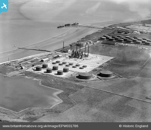
EPW031786 ENGLAND (1930). Oil terminal, North Killingholme Haven, 1930
© Copyright OpenStreetMap contributors and licensed by the OpenStreetMap Foundation. 2025. Cartography is licensed as CC BY-SA.
Nearby Images (21)
Details
| Title | [EPW031786] Oil terminal, North Killingholme Haven, 1930 |
| Reference | EPW031786 |
| Date | 30-April-1930 |
| Link | |
| Place name | NORTH KILLINGHOLME HAVEN |
| Parish | NORTH KILLINGHOLME |
| District | |
| Country | ENGLAND |
| Easting / Northing | 515894, 420648 |
| Longitude / Latitude | -0.24558967993296, 53.669212413781 |
| National Grid Reference | TA159206 |
Pins
 John Wass |
Wednesday 20th of May 2015 03:03:08 PM |


![[EPW031786] Oil terminal, North Killingholme Haven, 1930](http://britainfromabove.org.uk/sites/all/libraries/aerofilms-images/public/100x100/EPW/031/EPW031786.jpg)
![[EPW031787] Oil terminal, North Killingholme Haven, 1930](http://britainfromabove.org.uk/sites/all/libraries/aerofilms-images/public/100x100/EPW/031/EPW031787.jpg)
![[EPW031789] Oil terminal, North Killingholme Haven, 1930](http://britainfromabove.org.uk/sites/all/libraries/aerofilms-images/public/100x100/EPW/031/EPW031789.jpg)
![[EPW031620] Petroleum Refineries, North Killingholme Haven, 1930](http://britainfromabove.org.uk/sites/all/libraries/aerofilms-images/public/100x100/EPW/031/EPW031620.jpg)
![[EPW031788] Oil terminal, North Killingholme Haven, 1930](http://britainfromabove.org.uk/sites/all/libraries/aerofilms-images/public/100x100/EPW/031/EPW031788.jpg)
![[EPW031792] Oil terminal, North Killingholme Haven, 1930](http://britainfromabove.org.uk/sites/all/libraries/aerofilms-images/public/100x100/EPW/031/EPW031792.jpg)
![[EPW031791] Oil terminal, North Killingholme Haven, 1930](http://britainfromabove.org.uk/sites/all/libraries/aerofilms-images/public/100x100/EPW/031/EPW031791.jpg)
![[EPW031790] Oil terminal, North Killingholme Haven, 1930](http://britainfromabove.org.uk/sites/all/libraries/aerofilms-images/public/100x100/EPW/031/EPW031790.jpg)
![[EPW031612] Petroleum Refineries, North Killingholme Haven, 1930](http://britainfromabove.org.uk/sites/all/libraries/aerofilms-images/public/100x100/EPW/031/EPW031612.jpg)
![[EPW031610] Petroleum Refineries, North Killingholme Haven, 1930](http://britainfromabove.org.uk/sites/all/libraries/aerofilms-images/public/100x100/EPW/031/EPW031610.jpg)
![[EPW031613] Petroleum Refineries, North Killingholme Haven, 1930](http://britainfromabove.org.uk/sites/all/libraries/aerofilms-images/public/100x100/EPW/031/EPW031613.jpg)
![[EPW031614] Petroleum Refineries, North Killingholme Haven, 1930](http://britainfromabove.org.uk/sites/all/libraries/aerofilms-images/public/100x100/EPW/031/EPW031614.jpg)
![[EPW031611] Petroleum Refineries, North Killingholme Haven, 1930](http://britainfromabove.org.uk/sites/all/libraries/aerofilms-images/public/100x100/EPW/031/EPW031611.jpg)
![[EPW031616] Petroleum Refineries, North Killingholme Haven, 1930](http://britainfromabove.org.uk/sites/all/libraries/aerofilms-images/public/100x100/EPW/031/EPW031616.jpg)
![[EPW031615] Petroleum Refineries, North Killingholme Haven, 1930](http://britainfromabove.org.uk/sites/all/libraries/aerofilms-images/public/100x100/EPW/031/EPW031615.jpg)
![[EPW031794] Oil terminal, North Killingholme Haven, 1930. This image has been produced from a damaged negative](http://britainfromabove.org.uk/sites/all/libraries/aerofilms-images/public/100x100/EPW/031/EPW031794.jpg)
![[EPW031793] Oil terminal, North Killingholme Haven, 1930](http://britainfromabove.org.uk/sites/all/libraries/aerofilms-images/public/100x100/EPW/031/EPW031793.jpg)
![[EPW031618] Petroleum Refineries, North Killingholme Haven, 1930](http://britainfromabove.org.uk/sites/all/libraries/aerofilms-images/public/100x100/EPW/031/EPW031618.jpg)
![[EPW031617] Petroleum Refineries, North Killingholme Haven, 1930](http://britainfromabove.org.uk/sites/all/libraries/aerofilms-images/public/100x100/EPW/031/EPW031617.jpg)
![[EPW031619] Petroleum Refineries, North Killingholme Haven, 1930](http://britainfromabove.org.uk/sites/all/libraries/aerofilms-images/public/100x100/EPW/031/EPW031619.jpg)
![[EPW031609] Petroleum Refineries, East Halton, 1930](http://britainfromabove.org.uk/sites/all/libraries/aerofilms-images/public/100x100/EPW/031/EPW031609.jpg)