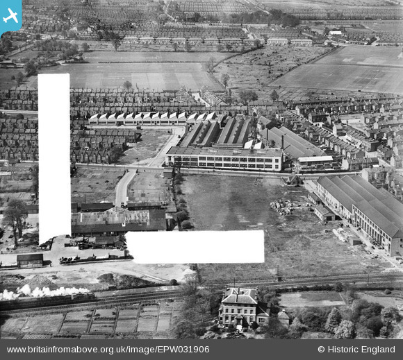
 These are the playing fields of the Sir George Monoux Grammar School (1921) also part of the former Chestnut's Farm site. The school building is just out of view to the right on the Chingford Road frontage. |
 8-2007.JPG)
Keith |
Monday 24th of June 2013 11:23:29 PM |
 Here are the Chestnuts Farm Allotments part of the Walthamstow Town's Allotments Association, in existence before the Walthamstow Borough Council built the nearby town hall and civic centre at Chestnuts Farm. |
 8-2007.JPG)
Keith |
Monday 24th of June 2013 11:21:20 PM |
 These houses in Chingford Road No; 151 - 195, together with a few on the other side were destroyed by a Nazi land mine explosion in 1941 and later a V.1 bomb during 1944. |
 8-2007.JPG)
Keith |
Monday 24th of June 2013 11:17:16 PM |
 Here is the site of Walthamstow Tram Depot opened in 1903 and converted to trolleybus operation 1936, and finally motor bus (RT & Routemaster) operation in 1960. It closed in 1991 and eventually became a housing estate - pity those poor people who's gardens were built over the former garage pits engineering area! |
 8-2007.JPG)
Keith |
Monday 24th of June 2013 11:14:42 PM |
 This is Farnan Avenue built 1905 as were the nearby local roads by Day & Sons. I have lived here since 1976 and the houses on the western side No'd 2-28 suffered a catastrophic hit by a Nazi V.2 rocket on early morning of 10th Sept 1944. They were never rebuilt as original design. I knew a Mrs Ruby Cave, then a young mother who was bombed out of No 22 and relocated to No 42. She would often reflect on her luck at being in the shelter that night as the bomb fell in the road at the front of the houses and that protected many of the rear garden areas. The person who had the most shock was her husband (Len) who came home later that day to find the house almost missing. |
 8-2007.JPG)
Keith |
Monday 24th of June 2013 11:10:59 PM |
 This is Chestnuts Farm formerly owned by the Hitchmans family until the First War and the site of their cornfields and part dairy herd grazing land.
The greater part of the area became the location (and still is) the Walthamstow town hall and assembly hall from 1938 [completed 1940-43] Beneath the town hall in the sub-basement was the London Group 7 Civil Defence ARP operations centre, later becoming the London NE Nuclear Defence HQ should it have been needed. It was only declassified in 1980 by central government. The impressive airlock doors are still in place. |
 8-2007.JPG)
Keith |
Monday 24th of June 2013 11:00:57 PM |
 This would be an 'N' type loco having just left Wood Street Station 3/4 mile off right, en route to Highams Park & Hale End Station 1 mile north and finally Chingford. |
 8-2007.JPG)
Keith |
Monday 24th of June 2013 10:51:36 PM |
 8-2007.JPG)
 8-2007.JPG)
 8-2007.JPG)
 8-2007.JPG)
 8-2007.JPG)
 8-2007.JPG)
 8-2007.JPG)


![[EPW031906] The Ensign Camera Works and environs, Walthamstow, 1930. This image has been marked by Aerofilms Ltd for photo editing.](http://britainfromabove.org.uk/sites/all/libraries/aerofilms-images/public/100x100/EPW/031/EPW031906.jpg)
![[EPW031908] The Ensign Camera Works and environs, Walthamstow, 1930. This image has been marked by Aerofilms Ltd for photo editing.](http://britainfromabove.org.uk/sites/all/libraries/aerofilms-images/public/100x100/EPW/031/EPW031908.jpg)
![[EPW031165] The Houghton-Butcher Manufacturing Co. Ltd Ensign Works (photographic apparatus), Walthamstow, 1929](http://britainfromabove.org.uk/sites/all/libraries/aerofilms-images/public/100x100/EPW/031/EPW031165.jpg)
![[EPW031907] The Ensign Camera Works and environs, Walthamstow, 1930. This image has been marked by Aerofilms Ltd for photo editing.](http://britainfromabove.org.uk/sites/all/libraries/aerofilms-images/public/100x100/EPW/031/EPW031907.jpg)
![[EPW031162] The Houghton-Butcher Manufacturing Co. Ltd Ensign Works (photographic apparatus), Walthamstow, 1929](http://britainfromabove.org.uk/sites/all/libraries/aerofilms-images/public/100x100/EPW/031/EPW031162.jpg)
![[EPW031163] The Houghton-Butcher Manufacturing Co. Ltd Ensign Works (photographic apparatus), Walthamstow, 1929](http://britainfromabove.org.uk/sites/all/libraries/aerofilms-images/public/100x100/EPW/031/EPW031163.jpg)
![[EPW031161] The Houghton-Butcher Manufacturing Co. Ltd Ensign Works (photographic apparatus), Walthamstow, 1929](http://britainfromabove.org.uk/sites/all/libraries/aerofilms-images/public/100x100/EPW/031/EPW031161.jpg)
![[EPW031164] The Houghton-Butcher Manufacturing Co. Ltd Ensign Works (photographic apparatus), Walthamstow, 1929](http://britainfromabove.org.uk/sites/all/libraries/aerofilms-images/public/100x100/EPW/031/EPW031164.jpg)
![[EAW049440] The Micanite & Insulators Co Ltd Works on Clifford Road and environs, Walthamstow, 1953. This image was marked by Aerofilms Ltd for photo editing.](http://britainfromabove.org.uk/sites/all/libraries/aerofilms-images/public/100x100/EAW/049/EAW049440.jpg)
![[EPW031160] The Houghton-Butcher Manufacturing Co. Ltd Ensign Works (photographic apparatus), Walthamstow, 1929](http://britainfromabove.org.uk/sites/all/libraries/aerofilms-images/public/100x100/EPW/031/EPW031160.jpg)
![[EAW049438] The Micanite & Insulators Co Ltd Works on Clifford Road and environs, Walthamstow, 1953. This image was marked by Aerofilms Ltd for photo editing.](http://britainfromabove.org.uk/sites/all/libraries/aerofilms-images/public/100x100/EAW/049/EAW049438.jpg)
![[EAW049439] The Micanite & Insulators Co Ltd Works on Clifford Road and environs, Walthamstow, 1953. This image was marked by Aerofilms Ltd for photo editing.](http://britainfromabove.org.uk/sites/all/libraries/aerofilms-images/public/100x100/EAW/049/EAW049439.jpg)
![[EAW049435] The Micanite & Insulators Co Ltd Works on Clifford Road and environs, Walthamstow, 1953. This image was marked by Aerofilms Ltd for photo editing.](http://britainfromabove.org.uk/sites/all/libraries/aerofilms-images/public/100x100/EAW/049/EAW049435.jpg)
![[EAW049434] The Micanite & Insulators Co Ltd Works on Clifford Road and environs, Walthamstow, 1953. This image was marked by Aerofilms Ltd for photo editing.](http://britainfromabove.org.uk/sites/all/libraries/aerofilms-images/public/100x100/EAW/049/EAW049434.jpg)
![[EAW049437] The Micanite & Insulators Co Ltd Works on Clifford Road and environs, Walthamstow, 1953. This image was marked by Aerofilms Ltd for photo editing.](http://britainfromabove.org.uk/sites/all/libraries/aerofilms-images/public/100x100/EAW/049/EAW049437.jpg)
![[EAW049432] The Micanite & Insulators Co Ltd Works on Clifford Road and environs, Walthamstow, 1953. This image was marked by Aerofilms Ltd for photo editing.](http://britainfromabove.org.uk/sites/all/libraries/aerofilms-images/public/100x100/EAW/049/EAW049432.jpg)
![[EAW049433] The Micanite & Insulators Co Ltd Works on Clifford Road and environs, Walthamstow, 1953. This image was marked by Aerofilms Ltd for photo editing.](http://britainfromabove.org.uk/sites/all/libraries/aerofilms-images/public/100x100/EAW/049/EAW049433.jpg)
![[EAW049436] The Micanite & Insulators Co Ltd Works on Clifford Road and environs, Walthamstow, 1953. This image was marked by Aerofilms Ltd for photo editing.](http://britainfromabove.org.uk/sites/all/libraries/aerofilms-images/public/100x100/EAW/049/EAW049436.jpg)