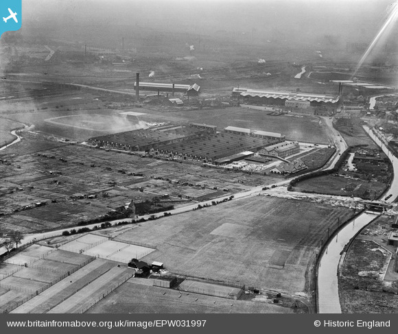
EPW031997 ENGLAND (1930). The Valor Works and environs, Bromford, 1930
© Copyright OpenStreetMap contributors and licensed by the OpenStreetMap Foundation. 2025. Cartography is licensed as CC BY-SA.
Nearby Images (10)
Details
| Title | [EPW031997] The Valor Works and environs, Bromford, 1930 |
| Reference | EPW031997 |
| Date | 16-May-1930 |
| Link | |
| Place name | BROMFORD |
| Parish | |
| District | |
| Country | ENGLAND |
| Easting / Northing | 411793, 290275 |
| Longitude / Latitude | -1.8262190830706, 52.509873243202 |
| National Grid Reference | SP118903 |
Pins
Be the first to add a comment to this image!


![[EPW031997] The Valor Works and environs, Bromford, 1930](http://britainfromabove.org.uk/sites/all/libraries/aerofilms-images/public/100x100/EPW/031/EPW031997.jpg)
![[EPW001103] Fort Dunlop Rubber Works, Bromford, from the west, 1920. This image has been produced from a damaged negative.](http://britainfromabove.org.uk/sites/all/libraries/aerofilms-images/public/100x100/EPW/001/EPW001103.jpg)
![[EPW031998A] The Valor Works, Bromford, 1930](http://britainfromabove.org.uk/sites/all/libraries/aerofilms-images/public/100x100/EPW/031/EPW031998A.jpg)
![[EPW031999] The Valor Works, Bromford, 1930](http://britainfromabove.org.uk/sites/all/libraries/aerofilms-images/public/100x100/EPW/031/EPW031999.jpg)
![[EPW031994] The Valor Works, Bromford, 1930](http://britainfromabove.org.uk/sites/all/libraries/aerofilms-images/public/100x100/EPW/031/EPW031994.jpg)
![[EPW032000] The Valor Works, Bromford, 1930](http://britainfromabove.org.uk/sites/all/libraries/aerofilms-images/public/100x100/EPW/032/EPW032000.jpg)
![[EPW031993] The Valor Works, Bromford, 1930](http://britainfromabove.org.uk/sites/all/libraries/aerofilms-images/public/100x100/EPW/031/EPW031993.jpg)
![[EPW031998] The Valor Works and environs, Bromford, 1930](http://britainfromabove.org.uk/sites/all/libraries/aerofilms-images/public/100x100/EPW/031/EPW031998.jpg)
![[EPW031995] The Valor Works and environs, Bromford, 1930](http://britainfromabove.org.uk/sites/all/libraries/aerofilms-images/public/100x100/EPW/031/EPW031995.jpg)
![[EPW031996] The Valor Works and environs, Bromford, 1930](http://britainfromabove.org.uk/sites/all/libraries/aerofilms-images/public/100x100/EPW/031/EPW031996.jpg)