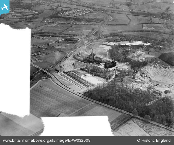
EPW032009 ENGLAND (1930). Anglo-Scottish Beet Sugar Factory and environs, Foley Park, 1930. This image was marked by Aerofilms Ltd for photo editing.
© Copyright OpenStreetMap contributors and licensed by the OpenStreetMap Foundation. 2025. Cartography is licensed as CC BY-SA.
Nearby Images (8)
Details
| Title | [EPW032009] Anglo-Scottish Beet Sugar Factory and environs, Foley Park, 1930. This image was marked by Aerofilms Ltd for photo editing. |
| Reference | EPW032009 |
| Date | May-1930 |
| Link | |
| Place name | FOLEY PARK |
| Parish | |
| District | |
| Country | ENGLAND |
| Easting / Northing | 382360, 274758 |
| Longitude / Latitude | -2.2591213951495, 52.370202385658 |
| National Grid Reference | SO824748 |
Pins
 Mr Jauncey |
Friday 7th of December 2012 08:57:02 PM | |
 Mr Jauncey |
Friday 7th of December 2012 08:57:01 PM | |
 Mr Jauncey |
Friday 7th of December 2012 08:56:58 PM | |
 Class31 |
Wednesday 7th of November 2012 08:17:11 PM | |
 Class31 |
Wednesday 7th of November 2012 08:13:47 PM | |
 Class31 |
Wednesday 7th of November 2012 08:11:21 PM | |
 Class31 |
Wednesday 7th of November 2012 08:10:54 PM |
User Comment Contributions
I believe the shed was erected two years after this Photo was taken. |
 ovpsteamesq. |
Wednesday 6th of March 2013 04:32:09 PM |


![[EPW032009] Anglo-Scottish Beet Sugar Factory and environs, Foley Park, 1930. This image was marked by Aerofilms Ltd for photo editing.](http://britainfromabove.org.uk/sites/all/libraries/aerofilms-images/public/100x100/EPW/032/EPW032009.jpg)
![[EPW032008] Anglo-Scottish Beet Sugar Factory and environs, Foley Park, 1930](http://britainfromabove.org.uk/sites/all/libraries/aerofilms-images/public/100x100/EPW/032/EPW032008.jpg)
![[EPW032002] Anglo-Scottish Beet Sugar Factory and environs, Foley Park, 1930](http://britainfromabove.org.uk/sites/all/libraries/aerofilms-images/public/100x100/EPW/032/EPW032002.jpg)
![[EPW032012] Anglo-Scottish Beet Sugar Factory and environs, Foley Park, 1930](http://britainfromabove.org.uk/sites/all/libraries/aerofilms-images/public/100x100/EPW/032/EPW032012.jpg)
![[EPW032007] Anglo-Scottish Beet Sugar Factory and environs, Foley Park, 1930](http://britainfromabove.org.uk/sites/all/libraries/aerofilms-images/public/100x100/EPW/032/EPW032007.jpg)
![[EPW032011] Anglo-Scottish Beet Sugar Factory and environs, Foley Park, 1930. This image was marked by Aerofilms Ltd for photo editing.](http://britainfromabove.org.uk/sites/all/libraries/aerofilms-images/public/100x100/EPW/032/EPW032011.jpg)
![[EPW032005] Anglo-Scottish Beet Sugar Factory and environs, Foley Park, 1930](http://britainfromabove.org.uk/sites/all/libraries/aerofilms-images/public/100x100/EPW/032/EPW032005.jpg)
![[EPW032001] Anglo-Scottish Beet Sugar Factory, Foley Park, 1930](http://britainfromabove.org.uk/sites/all/libraries/aerofilms-images/public/100x100/EPW/032/EPW032001.jpg)