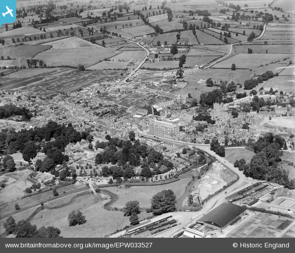
EPW033527 ENGLAND (1930). The town centre, Calne, from the south-west, 1930
© Copyright OpenStreetMap contributors and licensed by the OpenStreetMap Foundation. 2025. Cartography is licensed as CC BY-SA.
Nearby Images (28)
Details
| Title | [EPW033527] The town centre, Calne, from the south-west, 1930 |
| Reference | EPW033527 |
| Date | July-1930 |
| Link | |
| Place name | CALNE |
| Parish | CALNE |
| District | |
| Country | ENGLAND |
| Easting / Northing | 399626, 170810 |
| Longitude / Latitude | -2.0053810198448, 51.435797405983 |
| National Grid Reference | ST996708 |
Pins
 Dockgreen |
Sunday 12th of March 2017 11:58:30 AM | |
 Dockgreen |
Sunday 12th of March 2017 11:57:31 AM | |
 Class31 |
Wednesday 27th of March 2013 09:22:46 AM | |
 Class31 |
Wednesday 27th of March 2013 09:22:06 AM | |
 Maurice |
Tuesday 26th of March 2013 07:06:42 PM | |
 MB |
Monday 25th of March 2013 09:49:56 PM | |
 MB |
Monday 25th of March 2013 09:48:41 PM | |
 MB |
Monday 25th of March 2013 09:47:46 PM | |
 MB |
Monday 25th of March 2013 09:46:10 PM | |
 MB |
Monday 25th of March 2013 09:45:43 PM | |
 MB |
Monday 25th of March 2013 09:44:14 PM | |
 MB |
Monday 25th of March 2013 09:43:35 PM | |
Harris' Bi-product factory building was an RFC General Service Flight Shed formerly located at Yatesbury airfield; it was a 1917 Pattern Shed approx 80' by 170' |
 Steve Bedding |
Monday 3rd of June 2013 10:13:44 PM |
 MB |
Monday 25th of March 2013 09:42:34 PM | |
 MB |
Monday 25th of March 2013 09:41:27 PM | |
 MB |
Monday 25th of March 2013 09:40:20 PM | |
 MB |
Monday 25th of March 2013 09:39:49 PM | |
 MB |
Monday 25th of March 2013 09:39:18 PM |


![[EPW033527] The town centre, Calne, from the south-west, 1930](http://britainfromabove.org.uk/sites/all/libraries/aerofilms-images/public/100x100/EPW/033/EPW033527.jpg)
![[EPW033522] The Harris Bacon Factory and the town, Calne, from the south-west, 1930](http://britainfromabove.org.uk/sites/all/libraries/aerofilms-images/public/100x100/EPW/033/EPW033522.jpg)
![[EPW001114] View of Calne and the Harris Bacon Factory, Calne, from the west, 1920](http://britainfromabove.org.uk/sites/all/libraries/aerofilms-images/public/100x100/EPW/001/EPW001114.jpg)
![[EPR000052] The town, Calne, 1934. This image has been affected by flare.](http://britainfromabove.org.uk/sites/all/libraries/aerofilms-images/public/100x100/EPR/000/EPR000052.jpg)
![[EPR000050] The town, Calne, 1934](http://britainfromabove.org.uk/sites/all/libraries/aerofilms-images/public/100x100/EPR/000/EPR000050.jpg)
![[EPR000051] The town, Calne, 1934](http://britainfromabove.org.uk/sites/all/libraries/aerofilms-images/public/100x100/EPR/000/EPR000051.jpg)
![[EPR000054] The town, Calne, 1934. This image was marked by Aero Pictorial Ltd for photo editing.](http://britainfromabove.org.uk/sites/all/libraries/aerofilms-images/public/100x100/EPR/000/EPR000054.jpg)
![[EPW029301] Calne Railway Station and the town, Calne, 1929](http://britainfromabove.org.uk/sites/all/libraries/aerofilms-images/public/100x100/EPW/029/EPW029301.jpg)
![[EPW029302] The Harris Bacon Factory, St Mary's Church and the town, Calne, 1929](http://britainfromabove.org.uk/sites/all/libraries/aerofilms-images/public/100x100/EPW/029/EPW029302.jpg)
![[EPW029294] The Harris Bacon Factory, St Mary's Church and the town, Calne, 1929](http://britainfromabove.org.uk/sites/all/libraries/aerofilms-images/public/100x100/EPW/029/EPW029294.jpg)
![[EPW029289] The Harris Bacon Factory and the town, Calne, 1929](http://britainfromabove.org.uk/sites/all/libraries/aerofilms-images/public/100x100/EPW/029/EPW029289.jpg)
![[EPW029297] The Harris Bacon Factory, Calne, 1929](http://britainfromabove.org.uk/sites/all/libraries/aerofilms-images/public/100x100/EPW/029/EPW029297.jpg)
![[EPW011115] The Harris Bacon Factory, Calne, 1924](http://britainfromabove.org.uk/sites/all/libraries/aerofilms-images/public/100x100/EPW/011/EPW011115.jpg)
![[EPW029300] The Harris Bacon Factory, the Town Hall and Market Hill, Calne, 1929](http://britainfromabove.org.uk/sites/all/libraries/aerofilms-images/public/100x100/EPW/029/EPW029300.jpg)
![[EPR000047] C. and T. Harris (Calne) Ltd Bacon Factory and the town centre, Calne, 1934](http://britainfromabove.org.uk/sites/all/libraries/aerofilms-images/public/100x100/EPR/000/EPR000047.jpg)
![[EPR000049] C. and T. Harris (Calne) Ltd By-Products Factory at the railway station, Calne, 1934](http://britainfromabove.org.uk/sites/all/libraries/aerofilms-images/public/100x100/EPR/000/EPR000049.jpg)
![[EPR000053] Woodlands, Calne, 1934](http://britainfromabove.org.uk/sites/all/libraries/aerofilms-images/public/100x100/EPR/000/EPR000053.jpg)
![[EPR000046] C. and T. Harris (Calne) Ltd Bacon Factory and the town centre, Calne, 1934](http://britainfromabove.org.uk/sites/all/libraries/aerofilms-images/public/100x100/EPR/000/EPR000046.jpg)
![[EPR000048] C. and T. Harris (Calne) Ltd Bacon Factory and the town centre, Calne, 1934](http://britainfromabove.org.uk/sites/all/libraries/aerofilms-images/public/100x100/EPR/000/EPR000048.jpg)
![[EPW011112] The Harris Bacon Factory and The Strand, Calne, 1924](http://britainfromabove.org.uk/sites/all/libraries/aerofilms-images/public/100x100/EPW/011/EPW011112.jpg)
![[EPW033520] Kingsbury Green and environs, Calne, 1930](http://britainfromabove.org.uk/sites/all/libraries/aerofilms-images/public/100x100/EPW/033/EPW033520.jpg)
![[EPW033526] The town centre, Calne, 1930](http://britainfromabove.org.uk/sites/all/libraries/aerofilms-images/public/100x100/EPW/033/EPW033526.jpg)
![[EPW029293] The Harris Bacon Factory, High Street and The Strand, Calne, 1929](http://britainfromabove.org.uk/sites/all/libraries/aerofilms-images/public/100x100/EPW/029/EPW029293.jpg)
![[EPW001116] The Harris Bacon Factory and St Mary's Church, Calne, 1920](http://britainfromabove.org.uk/sites/all/libraries/aerofilms-images/public/100x100/EPW/001/EPW001116.jpg)
![[EPW033517] The Harris Bacon Factory and the town, Calne, 1930](http://britainfromabove.org.uk/sites/all/libraries/aerofilms-images/public/100x100/EPW/033/EPW033517.jpg)
![[EPR000055] Woodlands, Calne, 1934. This image has been affected by flare.](http://britainfromabove.org.uk/sites/all/libraries/aerofilms-images/public/100x100/EPR/000/EPR000055.jpg)
![[EPW033515] The Harris Bacon Factory and the town, Calne, 1930](http://britainfromabove.org.uk/sites/all/libraries/aerofilms-images/public/100x100/EPW/033/EPW033515.jpg)
![[EPW033516] The Harris Bacon Factory and the town centre, Calne, 1930](http://britainfromabove.org.uk/sites/all/libraries/aerofilms-images/public/100x100/EPW/033/EPW033516.jpg)