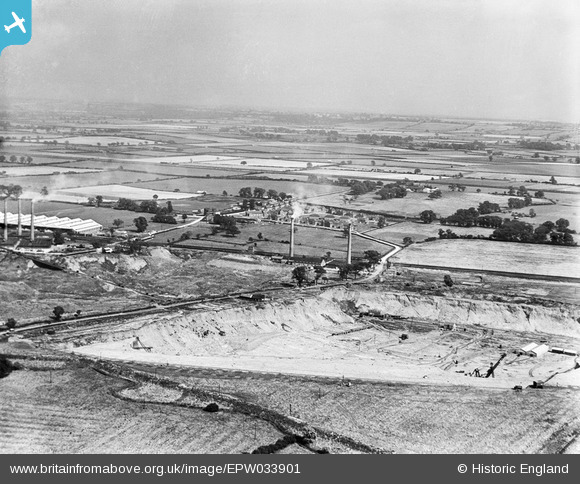
EPW033901 ENGLAND (1930). The Pillinge Brickworks and Wootton Pillinge, Marston Moretaine, from the west, 1930
© Copyright OpenStreetMap contributors and licensed by the OpenStreetMap Foundation. 2025. Cartography is licensed as CC BY-SA.
Nearby Images (16)
Details
| Title | [EPW033901] The Pillinge Brickworks and Wootton Pillinge, Marston Moretaine, from the west, 1930 |
| Reference | EPW033901 |
| Date | July-1930 |
| Link | |
| Place name | MARSTON MORETAINE |
| Parish | MARSTON MORETAINE |
| District | |
| Country | ENGLAND |
| Easting / Northing | 501120, 242472 |
| Longitude / Latitude | -0.52451765927731, 52.070954915956 |
| National Grid Reference | TL011425 |
Pins
 melgibbs |
Tuesday 14th of January 2014 07:43:17 PM | |
 melgibbs |
Tuesday 14th of January 2014 07:42:32 PM | |
 melgibbs |
Tuesday 14th of January 2014 07:42:01 PM | |
 melgibbs |
Tuesday 14th of January 2014 07:41:18 PM | |
 melgibbs |
Tuesday 14th of January 2014 07:40:45 PM | |
 melgibbs |
Tuesday 14th of January 2014 07:40:15 PM | |
 MB |
Saturday 11th of January 2014 06:54:54 PM | |
Yes, they did use cable-drawn wagons and later used conveyor belts, some of which were very long. |
 melgibbs |
Tuesday 14th of January 2014 07:39:47 PM |


![[EPW033901] The Pillinge Brickworks and Wootton Pillinge, Marston Moretaine, from the west, 1930](http://britainfromabove.org.uk/sites/all/libraries/aerofilms-images/public/100x100/EPW/033/EPW033901.jpg)
![[EPW026687] The London Brick Company and Forders Ltd Pillinge Brick Works, Stewartby, from the west, 1929](http://britainfromabove.org.uk/sites/all/libraries/aerofilms-images/public/100x100/EPW/026/EPW026687.jpg)
![[EPW033897] Oxford Clay extraction at the Pillinge Brickworks, Marston Moretaine, 1930](http://britainfromabove.org.uk/sites/all/libraries/aerofilms-images/public/100x100/EPW/033/EPW033897.jpg)
![[EPW026680] The London Brick Company and Forders Ltd Pillinge Brick Works, Stewartby, from the south-west, 1929](http://britainfromabove.org.uk/sites/all/libraries/aerofilms-images/public/100x100/EPW/026/EPW026680.jpg)
![[EPW026699] The London Brick Company and Forders Ltd Pillinge Brick Works, Stewartby, from the south-west, 1929](http://britainfromabove.org.uk/sites/all/libraries/aerofilms-images/public/100x100/EPW/026/EPW026699.jpg)
![[EPW026686] The London Brick Company and Forders Ltd Pillinge Brick Works, Stewartby, from the west, 1929](http://britainfromabove.org.uk/sites/all/libraries/aerofilms-images/public/100x100/EPW/026/EPW026686.jpg)
![[EPW026691] The London Brick Company and Forders Ltd Pillinge Brick Works, Stewartby, from the south-west, 1929](http://britainfromabove.org.uk/sites/all/libraries/aerofilms-images/public/100x100/EPW/026/EPW026691.jpg)
![[EPW026688] The London Brick Company and Forders Ltd Pillinge Brick Works, Stewartby, from the south-west, 1929](http://britainfromabove.org.uk/sites/all/libraries/aerofilms-images/public/100x100/EPW/026/EPW026688.jpg)
![[EPW026684] The London Brick Company and Forders Ltd Pillinge Brick Works, Stewartby, from the south-west, 1929](http://britainfromabove.org.uk/sites/all/libraries/aerofilms-images/public/100x100/EPW/026/EPW026684.jpg)
![[EAW011282] The London Brick Company Stewartby Brickworks and environs, Stewartby, from the south-west, 1947](http://britainfromabove.org.uk/sites/all/libraries/aerofilms-images/public/100x100/EAW/011/EAW011282.jpg)
![[EAW045597] The Stewartby Brick Works and environs, Stewartby, 1952. This image was marked by Aerofilms Ltd for photo editing.](http://britainfromabove.org.uk/sites/all/libraries/aerofilms-images/public/100x100/EAW/045/EAW045597.jpg)
![[EPW026690] The London Brick Company and Forders Ltd Pillinge Brick Works, Stewartby, from the south-west, 1929](http://britainfromabove.org.uk/sites/all/libraries/aerofilms-images/public/100x100/EPW/026/EPW026690.jpg)
![[EPW049679] The Pillinge Brick Works and environs, Stewartby, from the south-west, 1936](http://britainfromabove.org.uk/sites/all/libraries/aerofilms-images/public/100x100/EPW/049/EPW049679.jpg)
![[EPW033902] The Pillinge Brickworks and Wootton Pillinge, Stewartby, from the west, 1930](http://britainfromabove.org.uk/sites/all/libraries/aerofilms-images/public/100x100/EPW/033/EPW033902.jpg)
![[EPW054977] The London Brick Co Works, Stewartby, from the south-west, 1937](http://britainfromabove.org.uk/sites/all/libraries/aerofilms-images/public/100x100/EPW/054/EPW054977.jpg)
![[EPW033904] The Pillinge Brickworks, Stewartby, from the north-west, 1930](http://britainfromabove.org.uk/sites/all/libraries/aerofilms-images/public/100x100/EPW/033/EPW033904.jpg)