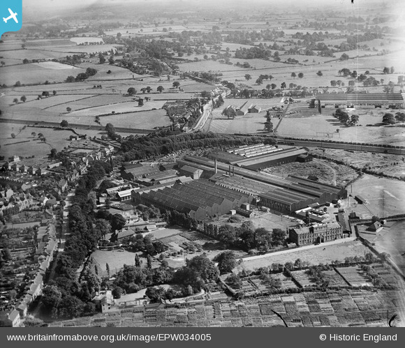
EPW034005 ENGLAND (1930). The English Electric Co Works, Stafford, from the north-west, 1930
© Copyright OpenStreetMap contributors and licensed by the OpenStreetMap Foundation. 2025. Cartography is licensed as CC BY-SA.
Nearby Images (8)
Details
| Title | [EPW034005] The English Electric Co Works, Stafford, from the north-west, 1930 |
| Reference | EPW034005 |
| Date | July-1930 |
| Link | |
| Place name | STAFFORD |
| Parish | |
| District | |
| Country | ENGLAND |
| Easting / Northing | 392913, 322404 |
| Longitude / Latitude | -2.1051243453474, 52.798817827784 |
| National Grid Reference | SJ929224 |
Pins
 deegee71 |
Tuesday 8th of December 2020 02:32:31 PM | |
 deegee71 |
Tuesday 8th of December 2020 02:29:52 PM | |
 deegee71 |
Tuesday 8th of December 2020 02:24:26 PM |


![[EPW034005] The English Electric Co Works, Stafford, from the north-west, 1930](http://britainfromabove.org.uk/sites/all/libraries/aerofilms-images/public/100x100/EPW/034/EPW034005.jpg)
![[EPW034002] The English Electric Co Works, Stafford, from the north-west, 1930](http://britainfromabove.org.uk/sites/all/libraries/aerofilms-images/public/100x100/EPW/034/EPW034002.jpg)
![[EPW020049] Siemens Electrical Engineering Works, Forebridge, 1927](http://britainfromabove.org.uk/sites/all/libraries/aerofilms-images/public/100x100/EPW/020/EPW020049.jpg)
![[EPW034007] The English Electric Co Works, Stafford, 1930](http://britainfromabove.org.uk/sites/all/libraries/aerofilms-images/public/100x100/EPW/034/EPW034007.jpg)
![[EPW034006] The English Electric Co Works, Stafford, 1930](http://britainfromabove.org.uk/sites/all/libraries/aerofilms-images/public/100x100/EPW/034/EPW034006.jpg)
![[EPW034003] The English Electric Co Works, Stafford, 1930](http://britainfromabove.org.uk/sites/all/libraries/aerofilms-images/public/100x100/EPW/034/EPW034003.jpg)
![[EPW034009] The English Electric Co Works, Stafford, 1930](http://britainfromabove.org.uk/sites/all/libraries/aerofilms-images/public/100x100/EPW/034/EPW034009.jpg)
![[EPW034004] The English Electric Co Works, Stafford, 1930](http://britainfromabove.org.uk/sites/all/libraries/aerofilms-images/public/100x100/EPW/034/EPW034004.jpg)