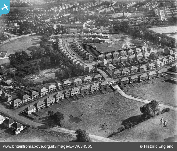
EPW034565 ENGLAND (1930). New housing at Orchard Crescent, Edgware, 1930
© Copyright OpenStreetMap contributors and licensed by the OpenStreetMap Foundation. 2025. Cartography is licensed as CC BY-SA.
Nearby Images (9)
Details
| Title | [EPW034565] New housing at Orchard Crescent, Edgware, 1930 |
| Reference | EPW034565 |
| Date | August-1930 |
| Link | |
| Place name | EDGWARE |
| Parish | |
| District | |
| Country | ENGLAND |
| Easting / Northing | 520191, 192168 |
| Longitude / Latitude | -0.26385865252481, 51.615021209907 |
| National Grid Reference | TQ202922 |
Pins
 Tony D |
Tuesday 21st of May 2013 05:16:00 PM | |
 Tony D |
Tuesday 21st of May 2013 05:15:18 PM | |
 Tony D |
Tuesday 21st of May 2013 05:14:45 PM | |
 Tony D |
Tuesday 21st of May 2013 05:14:22 PM | |
 Tony D |
Tuesday 21st of May 2013 05:13:55 PM | |
 Tony D |
Tuesday 21st of May 2013 05:13:32 PM |
User Comment Contributions
This is not Orchard Crescent, the adjoining roads don't fit in. I lived in the last house closest the camera. The road crossing should be Grange Hill but it never continued right across. The Lower Road should be Deans Way leading to Deans Lane. Needs a second look? |
 snapper31 |
Tuesday 21st of May 2013 05:12:36 PM |
It looks perfect to me. It fits exactly with maps of the time, right down to the number, orientation and size of the houses. You can even see the rawlplug works in the background! |
 Tony D |
Tuesday 21st of May 2013 05:12:36 PM |


![[EPW034565] New housing at Orchard Crescent, Edgware, 1930](http://britainfromabove.org.uk/sites/all/libraries/aerofilms-images/public/100x100/EPW/034/EPW034565.jpg)
![[EPW034563] New housing at Orchard Crescent, Edgware, 1930](http://britainfromabove.org.uk/sites/all/libraries/aerofilms-images/public/100x100/EPW/034/EPW034563.jpg)
![[EAW033380] Burnt Oak, Edgware and environs, Edgware, 1950. This image was marked by Aerofilms Ltd for photo editing.](http://britainfromabove.org.uk/sites/all/libraries/aerofilms-images/public/100x100/EAW/033/EAW033380.jpg)
![[EPW035549] Housing at Orchard Crescent, Grange Close and environs, Mill Hill, 1931](http://britainfromabove.org.uk/sites/all/libraries/aerofilms-images/public/100x100/EPW/035/EPW035549.jpg)
![[EAW033375] Burnt Oak, Edgware and environs, Burnt Oak, 1950](http://britainfromabove.org.uk/sites/all/libraries/aerofilms-images/public/100x100/EAW/033/EAW033375.jpg)
![[EPW034559] New housing at Orchard Crescent, Edgware, from the north-east, 1930](http://britainfromabove.org.uk/sites/all/libraries/aerofilms-images/public/100x100/EPW/034/EPW034559.jpg)
![[EPW035552] Housing surrounding Orchard Crescent, the Rawplug Co Ltd Works and environs, Mill Hill, 1931](http://britainfromabove.org.uk/sites/all/libraries/aerofilms-images/public/100x100/EPW/035/EPW035552.jpg)
![[EPW034566] New housing at Oakwood Drive, Edgware, 1930](http://britainfromabove.org.uk/sites/all/libraries/aerofilms-images/public/100x100/EPW/034/EPW034566.jpg)
![[EPW034611] A new housing estate under construction near Lower Hale, Edgware, 1930](http://britainfromabove.org.uk/sites/all/libraries/aerofilms-images/public/100x100/EPW/034/EPW034611.jpg)