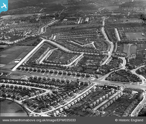
EPW035033 ENGLAND (1931). Spring Grove Crescent and environs, Lampton, 1931
© Copyright OpenStreetMap contributors and licensed by the OpenStreetMap Foundation. 2025. Cartography is licensed as CC BY-SA.
Details
| Title | [EPW035033] Spring Grove Crescent and environs, Lampton, 1931 |
| Reference | EPW035033 |
| Date | April-1931 |
| Link | |
| Place name | LAMPTON |
| Parish | |
| District | |
| Country | ENGLAND |
| Easting / Northing | 514038, 176730 |
| Longitude / Latitude | -0.35770213982655, 51.477533646816 |
| National Grid Reference | TQ140767 |
Pins
 Leslie B |
Wednesday 17th of November 2021 06:12:01 PM | |
 Class31 |
Friday 24th of July 2015 07:06:53 AM | |
 DepotCat |
Sunday 7th of June 2015 08:01:32 PM | |
 glennsalt@gmail.com |
Tuesday 28th of April 2015 09:14:42 AM | |
 glennsalt@gmail.com |
Tuesday 28th of April 2015 09:12:37 AM |
User Comment Contributions
Great West Road at Lampton Road, 22/07/2015 |
 Class31 |
Friday 24th of July 2015 07:05:49 AM |


![[EPW035033] Spring Grove Crescent and environs, Lampton, 1931](http://britainfromabove.org.uk/sites/all/libraries/aerofilms-images/public/100x100/EPW/035/EPW035033.jpg)
![[EPW035024] The Great West Road and new housing around Spring Grove Crescent, Lampton 1931](http://britainfromabove.org.uk/sites/all/libraries/aerofilms-images/public/100x100/EPW/035/EPW035024.jpg)
![[EPW023229] The Highlands, Hounslow, 1928](http://britainfromabove.org.uk/sites/all/libraries/aerofilms-images/public/100x100/EPW/023/EPW023229.jpg)
![[EPW056166] The London Transport Sports Ground, Osterley, 1937. This image has been produced from a print.](http://britainfromabove.org.uk/sites/all/libraries/aerofilms-images/public/100x100/EPW/056/EPW056166.jpg)