
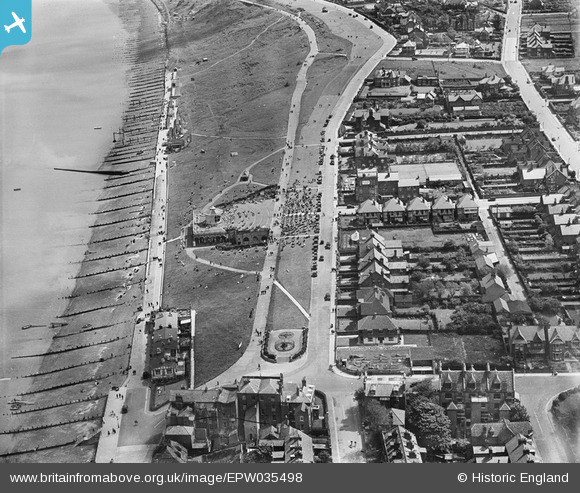
EPW035498 ENGLAND (1931). King's Hall and environs, Herne Bay, 1931
© Copyright OpenStreetMap contributors and licensed by the OpenStreetMap Foundation. 2025. Cartography is licensed as CC BY-SA.
Nearby Images (13)
EPW035498

EPW000535

EPW009206

EPW035495

EPW009205

EPW039301

EPW009203A

EPW035492

EPW054045

EPW039386

EPW035496

EPW000537

EPW035491

Details
| Title | [EPW035498] King's Hall and environs, Herne Bay, 1931 |
| Reference | EPW035498 |
| Date | May-1931 |
| Link | |
| Place name | HERNE BAY |
| Parish | |
| District | |
| Country | ENGLAND |
| Easting / Northing | 618385, 168369 |
| Longitude / Latitude | 1.1380333164663, 51.371814525327 |
| National Grid Reference | TR184684 |
Pins
 I in the sky |
Saturday 27th of October 2018 11:02:04 AM | |
Dodger |
Wednesday 9th of September 2015 11:06:13 PM | |
Dodger |
Wednesday 9th of September 2015 11:01:26 PM | |
Dodger |
Wednesday 9th of September 2015 11:00:33 PM | |
Pbrags |
Tuesday 14th of January 2014 03:43:02 PM |