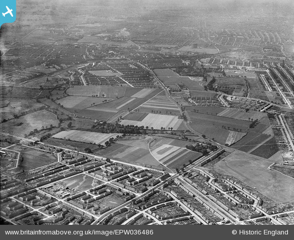
EPW036486 ENGLAND (1931). The site of the Leftley Estate and environs, Barking, 1931
© Copyright OpenStreetMap contributors and licensed by the OpenStreetMap Foundation. 2025. Cartography is licensed as CC BY-SA.
Details
| Title | [EPW036486] The site of the Leftley Estate and environs, Barking, 1931 |
| Reference | EPW036486 |
| Date | August-1931 |
| Link | |
| Place name | BARKING |
| Parish | |
| District | |
| Country | ENGLAND |
| Easting / Northing | 545890, 185260 |
| Longitude / Latitude | 0.10424310302374, 51.546869797254 |
| National Grid Reference | TQ459853 |
Pins
 GeoffBrown |
Wednesday 11th of February 2015 09:52:57 AM | |
 Chelsea61 |
Wednesday 3rd of July 2013 11:23:08 PM | |
 Chelsea61 |
Wednesday 3rd of July 2013 11:22:35 PM | |
 Chelsea61 |
Wednesday 3rd of July 2013 11:22:07 PM | |
 Chelsea61 |
Wednesday 3rd of July 2013 11:21:38 PM | |
 Chelsea61 |
Wednesday 3rd of July 2013 11:21:12 PM | |
 Chelsea61 |
Wednesday 3rd of July 2013 11:20:51 PM |


![[EPW036486] The site of the Leftley Estate and environs, Barking, 1931](http://britainfromabove.org.uk/sites/all/libraries/aerofilms-images/public/100x100/EPW/036/EPW036486.jpg)
![[EPW006553] A new housing estate under construction, Chadwell Heath, from the south-west, 1921](http://britainfromabove.org.uk/sites/all/libraries/aerofilms-images/public/100x100/EPW/006/EPW006553.jpg)
![[EAW043573] Park Modern secondary School and the Fair Cross area, Barking, 1952](http://britainfromabove.org.uk/sites/all/libraries/aerofilms-images/public/100x100/EAW/043/EAW043573.jpg)