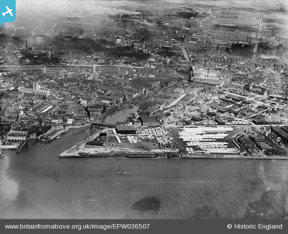
EPW036507 ENGLAND (1931). Garrison Side and the city, Kingston upon Hull, 1931
© Copyright OpenStreetMap contributors and licensed by the OpenStreetMap Foundation. 2025. Cartography is licensed as CC BY-SA.
Nearby Images (7)
Details
| Title | [EPW036507] Garrison Side and the city, Kingston upon Hull, 1931 |
| Reference | EPW036507 |
| Date | August-1931 |
| Link | |
| Place name | KINGSTON UPON HULL |
| Parish | |
| District | |
| Country | ENGLAND |
| Easting / Northing | 510278, 428506 |
| Longitude / Latitude | -0.32776653098342, 53.741034104625 |
| National Grid Reference | TA103285 |
Pins
 Doll |
Friday 13th of November 2020 10:05:37 PM | |
 John Wass |
Monday 29th of June 2015 12:08:04 PM | |
 David Jessop |
Thursday 30th of January 2014 09:51:57 PM |


![[EPW036507] Garrison Side and the city, Kingston upon Hull, 1931](http://britainfromabove.org.uk/sites/all/libraries/aerofilms-images/public/100x100/EPW/036/EPW036507.jpg)
![[EPW036382] The Old Harbour, Garrison Side and the city, Kingston upon Hull, 1931](http://britainfromabove.org.uk/sites/all/libraries/aerofilms-images/public/100x100/EPW/036/EPW036382.jpg)
![[EAW015658] The Old Harbour and city around Queen's Gardens, Kingston upon Hull, from the south-east, 1948. This image has been produced from a print.](http://britainfromabove.org.uk/sites/all/libraries/aerofilms-images/public/100x100/EAW/015/EAW015658.jpg)
![[EAW015645] The docks and the city, Kingston upon Hull, from the south, 1948](http://britainfromabove.org.uk/sites/all/libraries/aerofilms-images/public/100x100/EAW/015/EAW015645.jpg)
![[EPW036502] The River Hull and timber yards at Garrison Side, Kingston upon Hull, 1931](http://britainfromabove.org.uk/sites/all/libraries/aerofilms-images/public/100x100/EPW/036/EPW036502.jpg)
![[EPW036561] Garrison Side, Kingston upon Hull, 1931](http://britainfromabove.org.uk/sites/all/libraries/aerofilms-images/public/100x100/EPW/036/EPW036561.jpg)
![[EAW015638] The Humber Dock, Garrison Side and environs, Kingston upon Hull, 1948. This image has been produced from a print.](http://britainfromabove.org.uk/sites/all/libraries/aerofilms-images/public/100x100/EAW/015/EAW015638.jpg)