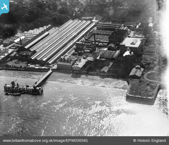
EPW036581 ENGLAND (1931). W.T. Henley's Electric Cable Works, Gravesend, 1931
© Copyright OpenStreetMap contributors and licensed by the OpenStreetMap Foundation. 2025. Cartography is licensed as CC BY-SA.
Nearby Images (28)
Details
| Title | [EPW036581] W.T. Henley's Electric Cable Works, Gravesend, 1931 |
| Reference | EPW036581 |
| Date | September-1931 |
| Link | |
| Place name | GRAVESEND |
| Parish | |
| District | |
| Country | ENGLAND |
| Easting / Northing | 563361, 174475 |
| Longitude / Latitude | 0.35102613877611, 51.445179916848 |
| National Grid Reference | TQ634745 |
Pins
Be the first to add a comment to this image!


![[EPW036581] W.T. Henley's Electric Cable Works, Gravesend, 1931](http://britainfromabove.org.uk/sites/all/libraries/aerofilms-images/public/100x100/EPW/036/EPW036581.jpg)
![[EPW032817] Henley's Electric Cable Works, Rosherville, 1930](http://britainfromabove.org.uk/sites/all/libraries/aerofilms-images/public/100x100/EPW/032/EPW032817.jpg)
![[EPW032818] Henley's Electric Cable Works, Rosherville, 1930](http://britainfromabove.org.uk/sites/all/libraries/aerofilms-images/public/100x100/EPW/032/EPW032818.jpg)
![[EPW036580] W.T. Henley's Electric Cable Works, Gravesend, 1931](http://britainfromabove.org.uk/sites/all/libraries/aerofilms-images/public/100x100/EPW/036/EPW036580.jpg)
![[EAW031130] W.T. Henley Electric Cable Works and environs, Rosherville, 1950](http://britainfromabove.org.uk/sites/all/libraries/aerofilms-images/public/100x100/EAW/031/EAW031130.jpg)
![[EPW036577] W.T. Henley's Electric Cable Works, Gravesend, 1931](http://britainfromabove.org.uk/sites/all/libraries/aerofilms-images/public/100x100/EPW/036/EPW036577.jpg)
![[EPW036579] W.T. Henley's Electric Cable Works, Gravesend, from the north-west, 1931](http://britainfromabove.org.uk/sites/all/libraries/aerofilms-images/public/100x100/EPW/036/EPW036579.jpg)
![[EPW032816] Henley's Electric Cable Works, Rosherville, 1930](http://britainfromabove.org.uk/sites/all/libraries/aerofilms-images/public/100x100/EPW/032/EPW032816.jpg)
![[EAW031131] W.T. Henley Electric Cable Works and environs, Rosherville, 1950. This image was marked by Aerofilms Ltd for photo editing.](http://britainfromabove.org.uk/sites/all/libraries/aerofilms-images/public/100x100/EAW/031/EAW031131.jpg)
![[EPW036588] W.T. Henley's Electric Cable Works, Gravesend, from the north-west, 1931](http://britainfromabove.org.uk/sites/all/libraries/aerofilms-images/public/100x100/EPW/036/EPW036588.jpg)
![[EAW031127] W.T. Henley Electric Cable Works and environs, Rosherville, 1950. This image was marked by Aerofilms Ltd for photo editing.](http://britainfromabove.org.uk/sites/all/libraries/aerofilms-images/public/100x100/EAW/031/EAW031127.jpg)
![[EAW031132] W.T. Henley Electric Cable Works and environs, Rosherville, 1950. This image was marked by Aerofilms Ltd for photo editing.](http://britainfromabove.org.uk/sites/all/libraries/aerofilms-images/public/100x100/EAW/031/EAW031132.jpg)
![[EPW036578] W.T. Henley's Electric Cable Works, Gravesend, 1931](http://britainfromabove.org.uk/sites/all/libraries/aerofilms-images/public/100x100/EPW/036/EPW036578.jpg)
![[EAW028716] The Amalgamated Press Ltd Printing Works on Crete Hall Road and environs, Rosherville, 1950. This image was marked by Aerofilms Ltd for photo editing.](http://britainfromabove.org.uk/sites/all/libraries/aerofilms-images/public/100x100/EAW/028/EAW028716.jpg)
![[EAW031123] W.T. Henley Electric Cable Works and environs, Rosherville, 1950. This image was marked by Aerofilms Ltd for photo editing.](http://britainfromabove.org.uk/sites/all/libraries/aerofilms-images/public/100x100/EAW/031/EAW031123.jpg)
![[EAW028719] The Amalgamated Press Ltd Printing Works and adjacent Henley Cables on Crete Hall Road and environs, Rosherville, 1950. This image was marked by Aerofilms Ltd for photo editing.](http://britainfromabove.org.uk/sites/all/libraries/aerofilms-images/public/100x100/EAW/028/EAW028719.jpg)
![[EAW031128] W.T. Henley Electric Cable Works and environs, Rosherville, 1950. This image was marked by Aerofilms Ltd for photo editing.](http://britainfromabove.org.uk/sites/all/libraries/aerofilms-images/public/100x100/EAW/031/EAW031128.jpg)
![[EAW031129] W.T. Henley Electric Cable Works and environs, Rosherville, 1950. This image was marked by Aerofilms Ltd for photo editing.](http://britainfromabove.org.uk/sites/all/libraries/aerofilms-images/public/100x100/EAW/031/EAW031129.jpg)
![[EPW036576] W.T. Henley's Electric Cable Works, Gravesend, 1931](http://britainfromabove.org.uk/sites/all/libraries/aerofilms-images/public/100x100/EPW/036/EPW036576.jpg)
![[EAW031126] W.T. Henley Electric Cable Works and environs, Rosherville, 1950. This image was marked by Aerofilms Ltd for photo editing.](http://britainfromabove.org.uk/sites/all/libraries/aerofilms-images/public/100x100/EAW/031/EAW031126.jpg)
![[EAW031125] W.T. Henley Electric Cable Works and environs, Rosherville, 1950. This image was marked by Aerofilms Ltd for photo editing.](http://britainfromabove.org.uk/sites/all/libraries/aerofilms-images/public/100x100/EAW/031/EAW031125.jpg)
![[EAW028718] The Amalgamated Press Ltd Printing Works on Crete Hall Road and environs, Rosherville, 1950. This image was marked by Aerofilms Ltd for photo editing.](http://britainfromabove.org.uk/sites/all/libraries/aerofilms-images/public/100x100/EAW/028/EAW028718.jpg)
![[EAW042093] The Imperial Paper Mills and environs, Gravesend, 1952. This image was marked by Aerofilms Ltd for photo editing.](http://britainfromabove.org.uk/sites/all/libraries/aerofilms-images/public/100x100/EAW/042/EAW042093.jpg)
![[EPW036582] W.T. Henley's Electric Cable Works and Rosherville Gardens, Gravesend, 1931](http://britainfromabove.org.uk/sites/all/libraries/aerofilms-images/public/100x100/EPW/036/EPW036582.jpg)
![[EAW028717] The Amalgamated Press Ltd Printing Works on Crete Hall Road and environs, Rosherville, 1950. This image was marked by Aerofilms Ltd for photo editing.](http://britainfromabove.org.uk/sites/all/libraries/aerofilms-images/public/100x100/EAW/028/EAW028717.jpg)
![[EAW031124] W.T. Henley Electric Cable Works and environs, Rosherville, 1950](http://britainfromabove.org.uk/sites/all/libraries/aerofilms-images/public/100x100/EAW/031/EAW031124.jpg)
![[EPW036587] W.T. Henley's Electric Cable Works and Rosherville Gardens, Gravesend, 1931](http://britainfromabove.org.uk/sites/all/libraries/aerofilms-images/public/100x100/EPW/036/EPW036587.jpg)
![[EAW028720] The Amalgamated Press Ltd Printing Works and adjacent Electric Cable Works on Crete Hall Road, Rosherville, 1950. This image was marked by Aerofilms Ltd for photo editing.](http://britainfromabove.org.uk/sites/all/libraries/aerofilms-images/public/100x100/EAW/028/EAW028720.jpg)