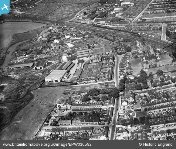
EPW036592 ENGLAND (1931). North Street and environs, Barking, 1931
© Copyright OpenStreetMap contributors and licensed by the OpenStreetMap Foundation. 2025. Cartography is licensed as CC BY-SA.
Nearby Images (16)
Details
| Title | [EPW036592] North Street and environs, Barking, 1931 |
| Reference | EPW036592 |
| Date | September-1931 |
| Link | |
| Place name | BARKING |
| Parish | |
| District | |
| Country | ENGLAND |
| Easting / Northing | 543878, 184472 |
| Longitude / Latitude | 0.074921431382472, 51.540305069827 |
| National Grid Reference | TQ439845 |
Pins
 Ferrers |
Saturday 17th of December 2022 08:24:20 PM | |
 John Chipperfield |
Tuesday 19th of April 2022 11:14:20 PM | |
 John Chipperfield |
Tuesday 19th of April 2022 11:07:23 PM |


![[EPW036592] North Street and environs, Barking, 1931](http://britainfromabove.org.uk/sites/all/libraries/aerofilms-images/public/100x100/EPW/036/EPW036592.jpg)
![[EPW060650] The Cape Asbestos Co Ltd Asbestos Works, Barking, 1939](http://britainfromabove.org.uk/sites/all/libraries/aerofilms-images/public/100x100/EPW/060/EPW060650.jpg)
![[EPW060647] The Cape Asbestos Co Ltd Asbestos Works, Barking, 1939](http://britainfromabove.org.uk/sites/all/libraries/aerofilms-images/public/100x100/EPW/060/EPW060647.jpg)
![[EPW060651] The Cape Asbestos Co Ltd Asbestos Works, Barking, 1939](http://britainfromabove.org.uk/sites/all/libraries/aerofilms-images/public/100x100/EPW/060/EPW060651.jpg)
![[EPW060644] The Cape Asbestos Co Ltd Asbestos Works, Barking, 1939](http://britainfromabove.org.uk/sites/all/libraries/aerofilms-images/public/100x100/EPW/060/EPW060644.jpg)
![[EPW060649] The Cape Asbestos Co Ltd Asbestos Works, Barking, 1939](http://britainfromabove.org.uk/sites/all/libraries/aerofilms-images/public/100x100/EPW/060/EPW060649.jpg)
![[EPW060646] The Cape Asbestos Co Ltd Asbestos Works, Barking, 1939](http://britainfromabove.org.uk/sites/all/libraries/aerofilms-images/public/100x100/EPW/060/EPW060646.jpg)
![[EPW060648] The Cape Asbestos Co Ltd Asbestos Works, Barking, 1939](http://britainfromabove.org.uk/sites/all/libraries/aerofilms-images/public/100x100/EPW/060/EPW060648.jpg)
![[EPW060645] The Cape Asbestos Co Ltd Asbestos Works, Barking, 1939](http://britainfromabove.org.uk/sites/all/libraries/aerofilms-images/public/100x100/EPW/060/EPW060645.jpg)
![[EAW037665] The Thames Plywood Manufactory Ltd Works, Barking, 1951. This image has been produced from a print marked by Aerofilms Ltd for photo editing.](http://britainfromabove.org.uk/sites/all/libraries/aerofilms-images/public/100x100/EAW/037/EAW037665.jpg)
![[EAW037662] The Thames Plywood Manufactory Ltd Works, Barking, 1951. This image has been produced from a print marked by Aerofilms Ltd for photo editing.](http://britainfromabove.org.uk/sites/all/libraries/aerofilms-images/public/100x100/EAW/037/EAW037662.jpg)
![[EAW037660] The Thames Plywood Manufactory Ltd Works, Barking, 1951. This image has been produced from a print marked by Aerofilms Ltd for photo editing.](http://britainfromabove.org.uk/sites/all/libraries/aerofilms-images/public/100x100/EAW/037/EAW037660.jpg)
![[EAW037658] The Thames Plywood Manufactory Ltd Works, Barking, 1951. This image has been produced from a print marked by Aerofilms Ltd for photo editing.](http://britainfromabove.org.uk/sites/all/libraries/aerofilms-images/public/100x100/EAW/037/EAW037658.jpg)
![[EAW037657] The Thames Plywood Manufactory Ltd Works, Barking, 1951. This image has been produced from a print marked by Aerofilms Ltd for photo editing.](http://britainfromabove.org.uk/sites/all/libraries/aerofilms-images/public/100x100/EAW/037/EAW037657.jpg)
![[EAW037663] The Thames Plywood Manufactory Ltd Works, Barking, 1951. This image has been produced from a print marked by Aerofilms Ltd for photo editing.](http://britainfromabove.org.uk/sites/all/libraries/aerofilms-images/public/100x100/EAW/037/EAW037663.jpg)
![[EAW037659] The Thames Plywood Manufactory Ltd Works, Barking, 1951. This image has been produced from a print marked by Aerofilms Ltd for photo editing.](http://britainfromabove.org.uk/sites/all/libraries/aerofilms-images/public/100x100/EAW/037/EAW037659.jpg)