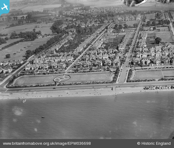
EPW036698 ENGLAND (1931). Housing surrounding The Broadway, Tyrone Road and Thorpe Bay Gardens, Thorpe Bay, 1931
© Copyright OpenStreetMap contributors and licensed by the OpenStreetMap Foundation. 2024. Cartography is licensed as CC BY-SA.
Nearby Images (7)
Details
| Title | [EPW036698] Housing surrounding The Broadway, Tyrone Road and Thorpe Bay Gardens, Thorpe Bay, 1931 |
| Reference | EPW036698 |
| Date | September-1931 |
| Link | |
| Place name | THORPE BAY |
| Parish | |
| District | |
| Country | ENGLAND |
| Easting / Northing | 591241, 184796 |
| Longitude / Latitude | 0.75739222131216, 51.529157156631 |
| National Grid Reference | TQ912848 |
Pins
 bargee1937 |
Wednesday 16th of September 2015 01:13:33 PM | |
 bargee1937 |
Wednesday 16th of September 2015 01:11:04 PM |


![[EPW036698] Housing surrounding The Broadway, Tyrone Road and Thorpe Bay Gardens, Thorpe Bay, 1931](http://britainfromabove.org.uk/sites/all/libraries/aerofilms-images/public/100x100/EPW/036/EPW036698.jpg)
![[EPW036746] Thorpe Bay Gardens, The Broadway and beach huts along the seafront, Thorpe Bay, 1931](http://britainfromabove.org.uk/sites/all/libraries/aerofilms-images/public/100x100/EPW/036/EPW036746.jpg)
![[EPW036721] Housing surrounding The Broadway, Tyrone Road and Thorpe Bay Gardens, Southend-on-Sea, from the south, 1931](http://britainfromabove.org.uk/sites/all/libraries/aerofilms-images/public/100x100/EPW/036/EPW036721.jpg)
![[EPW036747] Thorpe Bay Gardens, Tyrone Road and Thorpe Bay Esplanade, Thorpe Bay, from the south, 1931](http://britainfromabove.org.uk/sites/all/libraries/aerofilms-images/public/100x100/EPW/036/EPW036747.jpg)
![[EPW024875] Thorpe Bay Esplanade, Southchurch Park and the town, Southend-on-Sea, from the east, 1928](http://britainfromabove.org.uk/sites/all/libraries/aerofilms-images/public/100x100/EPW/024/EPW024875.jpg)
![[EPW036748] Thorpe Bay Esplanade, housing surrounding Gloucester Terrace and beach huts along the seafront, Thorpe Bay, 1931](http://britainfromabove.org.uk/sites/all/libraries/aerofilms-images/public/100x100/EPW/036/EPW036748.jpg)
![[EPW040983] Housing along the Thorpe Bay Esplanade, Southend-on-Sea, from the south-east, 1933](http://britainfromabove.org.uk/sites/all/libraries/aerofilms-images/public/100x100/EPW/040/EPW040983.jpg)