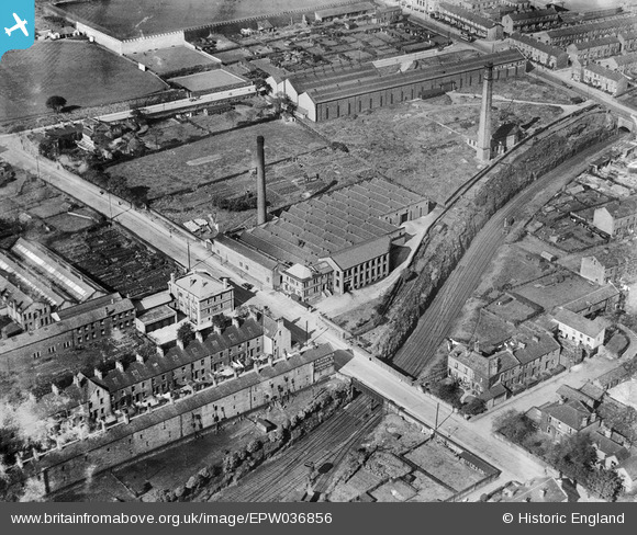
EPW036856 ENGLAND (1931). The Kingston Confectionery Works on Hopwood Lane, Halifax, 1931
© Copyright OpenStreetMap contributors and licensed by the OpenStreetMap Foundation. 2025. Cartography is licensed as CC BY-SA.
Nearby Images (23)
Details
| Title | [EPW036856] The Kingston Confectionery Works on Hopwood Lane, Halifax, 1931 |
| Reference | EPW036856 |
| Date | September-1931 |
| Link | |
| Place name | HALIFAX |
| Parish | |
| District | |
| Country | ENGLAND |
| Easting / Northing | 407758, 424919 |
| Longitude / Latitude | -1.8824218169481, 53.720398612773 |
| National Grid Reference | SE078249 |
Pins
 RT |
Monday 12th of March 2018 02:45:12 PM | |
 David |
Monday 21st of January 2013 01:41:14 PM | |
What are the strange uprights, looking over the backs of houses on Vickerman Street? They appear to be in line with the windows of the houses. What are they for? Who would have installed them? I'm intrigued... |
 Scouseinmanc |
Tuesday 23rd of January 2018 04:28:01 PM |


![[EPW036856] The Kingston Confectionery Works on Hopwood Lane, Halifax, 1931](http://britainfromabove.org.uk/sites/all/libraries/aerofilms-images/public/100x100/EPW/036/EPW036856.jpg)
![[EPW036851] The Kingston Confectionery Works on Hopwood Lane, Halifax, 1931](http://britainfromabove.org.uk/sites/all/libraries/aerofilms-images/public/100x100/EPW/036/EPW036851.jpg)
![[EPW036850] The Kingston Confectionery Works on Hopwood Lane, Halifax, 1931](http://britainfromabove.org.uk/sites/all/libraries/aerofilms-images/public/100x100/EPW/036/EPW036850.jpg)
![[EPW036854] The Kingston Confectionery Works on Hopwood Lane, Halifax, 1931](http://britainfromabove.org.uk/sites/all/libraries/aerofilms-images/public/100x100/EPW/036/EPW036854.jpg)
![[EPW036855] The Kingston Confectionery Works on Hopwood Lane, Halifax, 1931](http://britainfromabove.org.uk/sites/all/libraries/aerofilms-images/public/100x100/EPW/036/EPW036855.jpg)
![[EPW036852] The Kingston Confectionery Works on Hopwood Lane, Halifax, 1931](http://britainfromabove.org.uk/sites/all/libraries/aerofilms-images/public/100x100/EPW/036/EPW036852.jpg)
![[EPW036853] The Kingston Confectionery Works on Hopwood Lane, Halifax, 1931](http://britainfromabove.org.uk/sites/all/libraries/aerofilms-images/public/100x100/EPW/036/EPW036853.jpg)
![[EAW004555] Mile Thorn Machine Tool Works and environs, Halifax, from the south, 1947. This image was marked by Aerofilms Ltd for photo editing.](http://britainfromabove.org.uk/sites/all/libraries/aerofilms-images/public/100x100/EAW/004/EAW004555.jpg)
![[EAW028038] The Butler Machine Tool Co Ltd Mile Thorn Works, Halifax, 1950. This image was marked by Aerofilms Ltd for photo editing.](http://britainfromabove.org.uk/sites/all/libraries/aerofilms-images/public/100x100/EAW/028/EAW028038.jpg)
![[EAW028035] The Butler Machine Tool Co Ltd Mile Thorn Works, Halifax, 1950. This image was marked by Aerofilms Ltd for photo editing.](http://britainfromabove.org.uk/sites/all/libraries/aerofilms-images/public/100x100/EAW/028/EAW028035.jpg)
![[EAW004551] Mile Thorn Machine Tool Works and environs, Halifax, 1947](http://britainfromabove.org.uk/sites/all/libraries/aerofilms-images/public/100x100/EAW/004/EAW004551.jpg)
![[EAW028041] The Butler Machine Tool Co Ltd Mile Thorn Works, Halifax, 1950. This image has been produced from a damaged negative.](http://britainfromabove.org.uk/sites/all/libraries/aerofilms-images/public/100x100/EAW/028/EAW028041.jpg)
![[EAW028030] The Butler Machine Tool Co Ltd Mile Thorn Works, Halifax, 1950. This image has been produced from a damaged negative.](http://britainfromabove.org.uk/sites/all/libraries/aerofilms-images/public/100x100/EAW/028/EAW028030.jpg)
![[EAW028031] The Butler Machine Tool Co Ltd Mile Thorn Works, Halifax, 1950. This image has been produced from a damaged negative.](http://britainfromabove.org.uk/sites/all/libraries/aerofilms-images/public/100x100/EAW/028/EAW028031.jpg)
![[EAW028039] The Butler Machine Tool Co Ltd Mile Thorn Works, Halifax, 1950. This image was marked by Aerofilms Ltd for photo editing.](http://britainfromabove.org.uk/sites/all/libraries/aerofilms-images/public/100x100/EAW/028/EAW028039.jpg)
![[EAW004552] Mile Thorn Machine Tool Works and Gibbet Street, Halifax, 1947](http://britainfromabove.org.uk/sites/all/libraries/aerofilms-images/public/100x100/EAW/004/EAW004552.jpg)
![[EAW028034] The Butler Machine Tool Co Ltd Mile Thorn Works, Halifax, 1950. This image has been produced from a damaged negative.](http://britainfromabove.org.uk/sites/all/libraries/aerofilms-images/public/100x100/EAW/028/EAW028034.jpg)
![[EAW028040] The Butler Machine Tool Co Ltd Mile Thorn Works, Halifax, 1950. This image was marked by Aerofilms Ltd for photo editing.](http://britainfromabove.org.uk/sites/all/libraries/aerofilms-images/public/100x100/EAW/028/EAW028040.jpg)
![[EAW004557] Mile Thorn Machine Tool Works and environs, Halifax, from the north, 1947](http://britainfromabove.org.uk/sites/all/libraries/aerofilms-images/public/100x100/EAW/004/EAW004557.jpg)
![[EAW004554] Mile Thorn Machine Tool Works and environs, Halifax, from the west, 1947. This image was marked by Aerofilms Ltd for photo editing.](http://britainfromabove.org.uk/sites/all/libraries/aerofilms-images/public/100x100/EAW/004/EAW004554.jpg)
![[EAW004553] Mile Thorn Machine Tool Works and environs, Halifax, from the north-west, 1947](http://britainfromabove.org.uk/sites/all/libraries/aerofilms-images/public/100x100/EAW/004/EAW004553.jpg)
![[EAW004556] Mile Thorn Machine Tool Works and environs, Halifax, from the north-west, 1947. This image was marked by Aerofilms Ltd for photo editing.](http://britainfromabove.org.uk/sites/all/libraries/aerofilms-images/public/100x100/EAW/004/EAW004556.jpg)
![[EAW004558] Mile Thorn Machine Tool Works and environs, Halifax, from the north-west, 1947.This image was marked by Aerofilms Ltd for photo editing.](http://britainfromabove.org.uk/sites/all/libraries/aerofilms-images/public/100x100/EAW/004/EAW004558.jpg)