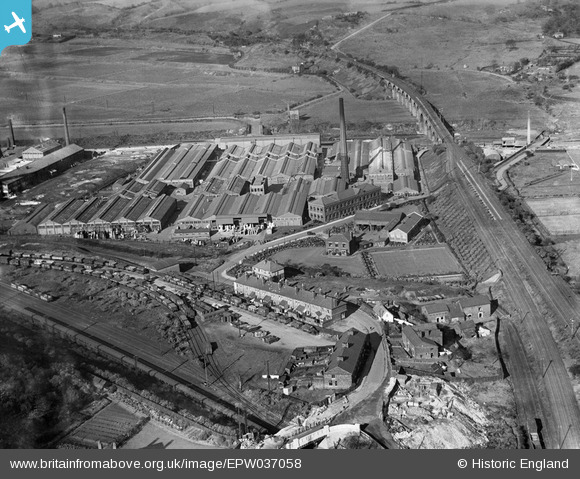
EPW037058 ENGLAND (1931). The Chloride Electrical Storage Works, Clifton Junction, 1931
© Copyright OpenStreetMap contributors and licensed by the OpenStreetMap Foundation. 2025. Cartography is licensed as CC BY-SA.
Nearby Images (29)
Details
| Title | [EPW037058] The Chloride Electrical Storage Works, Clifton Junction, 1931 |
| Reference | EPW037058 |
| Date | October-1931 |
| Link | |
| Place name | CLIFTON JUNCTION |
| Parish | |
| District | |
| Country | ENGLAND |
| Easting / Northing | 379181, 403182 |
| Longitude / Latitude | -2.3140710404616, 53.52464392523 |
| National Grid Reference | SD792032 |
Pins
 Pablo |
Tuesday 3rd of December 2024 01:37:36 PM | |
 Pablo |
Tuesday 3rd of December 2024 01:36:08 PM | |
 Pablo |
Tuesday 3rd of December 2024 01:33:34 PM |


![[EPW037058] The Chloride Electrical Storage Works, Clifton Junction, 1931](http://britainfromabove.org.uk/sites/all/libraries/aerofilms-images/public/100x100/EPW/037/EPW037058.jpg)
![[EPW037062] The Chloride Electrical Storage Works and surrounding countryside, Clifton Junction, 1931](http://britainfromabove.org.uk/sites/all/libraries/aerofilms-images/public/100x100/EPW/037/EPW037062.jpg)
![[EPW037059] The Chloride Electrical Storage Works, Clifton Junction, 1931](http://britainfromabove.org.uk/sites/all/libraries/aerofilms-images/public/100x100/EPW/037/EPW037059.jpg)
![[EPW044420] The Chloride Electrical Storage Company Exide Works, Clifton Junction, 1934. This image has been produced from a damaged negative.](http://britainfromabove.org.uk/sites/all/libraries/aerofilms-images/public/100x100/EPW/044/EPW044420.jpg)
![[EPW037065] The Chloride Electrical Storage Works and the Clifton Viaduct, Clifton Junction, 1931](http://britainfromabove.org.uk/sites/all/libraries/aerofilms-images/public/100x100/EPW/037/EPW037065.jpg)
![[EPW037061] The Chloride Electrical Storage Works and the Clifton Viaduct, Clifton Junction, 1931](http://britainfromabove.org.uk/sites/all/libraries/aerofilms-images/public/100x100/EPW/037/EPW037061.jpg)
![[EPW044416] The Chloride Electrical Storage Company Exide Works and environs, Clifton Junction, 1934](http://britainfromabove.org.uk/sites/all/libraries/aerofilms-images/public/100x100/EPW/044/EPW044416.jpg)
![[EPW044414] The Chloride Electrical Storage Company Exide Works, Clifton Junction, 1934](http://britainfromabove.org.uk/sites/all/libraries/aerofilms-images/public/100x100/EPW/044/EPW044414.jpg)
![[EPW037064] The Chloride Electrical Storage Works and the Clifton Viaduct, Clifton Junction, 1931](http://britainfromabove.org.uk/sites/all/libraries/aerofilms-images/public/100x100/EPW/037/EPW037064.jpg)
![[EPW044415] The Chloride Electrical Storage Company Exide Works, the Pilkington Tile and Pottery Works, and the cricket ground, Clifton Junction, 1934](http://britainfromabove.org.uk/sites/all/libraries/aerofilms-images/public/100x100/EPW/044/EPW044415.jpg)
![[EPW037060] The Chloride Electrical Storage Works and the Clifton Junction Sewage Farm, Clifton Junction, 1931](http://britainfromabove.org.uk/sites/all/libraries/aerofilms-images/public/100x100/EPW/037/EPW037060.jpg)
![[EPW037063] The Chloride Electrical Storage Works and the Clifton Viaduct, Clifton Junction, 1931](http://britainfromabove.org.uk/sites/all/libraries/aerofilms-images/public/100x100/EPW/037/EPW037063.jpg)
![[EPW045102] The Chloride Electrical Storage Works, Clifton Junction, 1934](http://britainfromabove.org.uk/sites/all/libraries/aerofilms-images/public/100x100/EPW/045/EPW045102.jpg)
![[EPW037066] The Chloride Electrical Storage Works and Pilkington's Tile and Pottery Works, Clifton Junction, 1931](http://britainfromabove.org.uk/sites/all/libraries/aerofilms-images/public/100x100/EPW/037/EPW037066.jpg)
![[EPW045104] The Chloride Electrical Storage Works, Clifton Junction, 1934](http://britainfromabove.org.uk/sites/all/libraries/aerofilms-images/public/100x100/EPW/045/EPW045104.jpg)
![[EPW044419] The Chloride Electrical Storage Company Exide Works, Clifton Junction, 1934. This image has been produced from a damaged negative.](http://britainfromabove.org.uk/sites/all/libraries/aerofilms-images/public/100x100/EPW/044/EPW044419.jpg)
![[EPW045100] The Chloride Electrical Storage Works, Clifton Junction, 1934](http://britainfromabove.org.uk/sites/all/libraries/aerofilms-images/public/100x100/EPW/045/EPW045100.jpg)
![[EPW045106] The Chloride Electrical Storage Works, Clifton Junction, 1934](http://britainfromabove.org.uk/sites/all/libraries/aerofilms-images/public/100x100/EPW/045/EPW045106.jpg)
![[EPW045101] The Chloride Electrical Storage Works, Clifton Junction, 1934](http://britainfromabove.org.uk/sites/all/libraries/aerofilms-images/public/100x100/EPW/045/EPW045101.jpg)
![[EPW013132] The Exide Battery Works, Clifton Junction, 1925. This image has been produced from a print.](http://britainfromabove.org.uk/sites/all/libraries/aerofilms-images/public/100x100/EPW/013/EPW013132.jpg)
![[EPW044418] The Chloride Electrical Storage Company Exide Works and environs, Clifton Junction, from the south-east, 1934](http://britainfromabove.org.uk/sites/all/libraries/aerofilms-images/public/100x100/EPW/044/EPW044418.jpg)
![[EPW045105] The Chloride Electrical Storage Works, Clifton Junction, 1934](http://britainfromabove.org.uk/sites/all/libraries/aerofilms-images/public/100x100/EPW/045/EPW045105.jpg)
![[EPW045103] The Chloride Electrical Storage Works, Clifton Junction, 1934](http://britainfromabove.org.uk/sites/all/libraries/aerofilms-images/public/100x100/EPW/045/EPW045103.jpg)
![[EPW044417] The Chloride Electrical Storage Company Exide Works and environs, Clifton Junction, from the south-east, 1934](http://britainfromabove.org.uk/sites/all/libraries/aerofilms-images/public/100x100/EPW/044/EPW044417.jpg)
![[EPW044412] The Chloride Electrical Storage Company Exide Works and environs, Clifton Junction, from the south, 1934](http://britainfromabove.org.uk/sites/all/libraries/aerofilms-images/public/100x100/EPW/044/EPW044412.jpg)
![[EPW044413] The Chloride Electrical Storage Company Exide Works and environs, Clifton Junction, from the east, 1934](http://britainfromabove.org.uk/sites/all/libraries/aerofilms-images/public/100x100/EPW/044/EPW044413.jpg)
![[EPW057311] Pilkington's Tile and Pottery Company Ltd, Clifton Junction, 1938](http://britainfromabove.org.uk/sites/all/libraries/aerofilms-images/public/100x100/EPW/057/EPW057311.jpg)
![[EPW057309] Pilkington's Tile and Pottery Company Ltd, Clifton Junction, 1938](http://britainfromabove.org.uk/sites/all/libraries/aerofilms-images/public/100x100/EPW/057/EPW057309.jpg)
![[EPW057310] Pilkington's Tile and Pottery Company Ltd, Clifton Junction, 1938](http://britainfromabove.org.uk/sites/all/libraries/aerofilms-images/public/100x100/EPW/057/EPW057310.jpg)