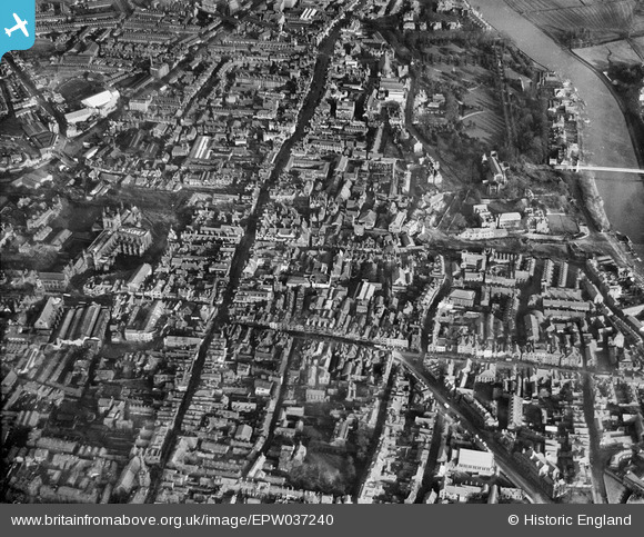
EPW037240 ENGLAND (1931). Foregate Street and the city centre, Chester, 1931
© Copyright OpenStreetMap contributors and licensed by the OpenStreetMap Foundation. 2025. Cartography is licensed as CC BY-SA.
Nearby Images (24)
Details
| Title | [EPW037240] Foregate Street and the city centre, Chester, 1931 |
| Reference | EPW037240 |
| Date | November-1931 |
| Link | |
| Place name | CHESTER |
| Parish | |
| District | |
| Country | ENGLAND |
| Easting / Northing | 340673, 366256 |
| Longitude / Latitude | -2.8880154780455, 53.189794494121 |
| National Grid Reference | SJ407663 |


![[EPW037240] Foregate Street and the city centre, Chester, 1931](http://britainfromabove.org.uk/sites/all/libraries/aerofilms-images/public/100x100/EPW/037/EPW037240.jpg)
![[EPW029881] Newgate Street and environs, Chester, 1929](http://britainfromabove.org.uk/sites/all/libraries/aerofilms-images/public/100x100/EPW/029/EPW029881.jpg)
![[EPW003097] The Cathedral Church of Christ and the Blessed Virgin Mary, Chester, 1920](http://britainfromabove.org.uk/sites/all/libraries/aerofilms-images/public/100x100/EPW/003/EPW003097.jpg)
![[EPW058002] The city centre, Chester, 1938. This image has been produced from a copy-negative.](http://britainfromabove.org.uk/sites/all/libraries/aerofilms-images/public/100x100/EPW/058/EPW058002.jpg)
![[EPW029885] Eastgate Street and environs, Chester, 1929](http://britainfromabove.org.uk/sites/all/libraries/aerofilms-images/public/100x100/EPW/029/EPW029885.jpg)
![[EPW040164] Bridge Street and the city centre, Chester, 1932](http://britainfromabove.org.uk/sites/all/libraries/aerofilms-images/public/100x100/EPW/040/EPW040164.jpg)
![[EPW029883] The Cathedral Church of Christ and the Blessed Virgin Mary and environs, Chester, 1929](http://britainfromabove.org.uk/sites/all/libraries/aerofilms-images/public/100x100/EPW/029/EPW029883.jpg)
![[EPW037241] Eastgate Street and the city centre, Chester, 1931](http://britainfromabove.org.uk/sites/all/libraries/aerofilms-images/public/100x100/EPW/037/EPW037241.jpg)
![[EPW005884] Bridge Street, Chester, 1921. This image has been produced from a copy-negative.](http://britainfromabove.org.uk/sites/all/libraries/aerofilms-images/public/100x100/EPW/005/EPW005884.jpg)
![[EPW036909] Bridge Street and the city centre, Chester, from the south-east, 1931](http://britainfromabove.org.uk/sites/all/libraries/aerofilms-images/public/100x100/EPW/036/EPW036909.jpg)
![[EPW029884] Watergate Street and Eastgate Street, Chester, 1929](http://britainfromabove.org.uk/sites/all/libraries/aerofilms-images/public/100x100/EPW/029/EPW029884.jpg)
![[EPW029886] The Cathedral Church of Christ and the Blessed Virgin Mary and environs, Chester, 1929](http://britainfromabove.org.uk/sites/all/libraries/aerofilms-images/public/100x100/EPW/029/EPW029886.jpg)
![[EPW004006] The Cathedral Church of Christ and the Blessed Virgin Mary and the city, Chester, 1920. This image has been produced from a print.](http://britainfromabove.org.uk/sites/all/libraries/aerofilms-images/public/100x100/EPW/004/EPW004006.jpg)
![[EPW040162] Chester Cathedral and Market Square, Chester, 1932](http://britainfromabove.org.uk/sites/all/libraries/aerofilms-images/public/100x100/EPW/040/EPW040162.jpg)
![[EPW005885] Chester Cathedral, Chester, 1921. This image has been produced from a print.](http://britainfromabove.org.uk/sites/all/libraries/aerofilms-images/public/100x100/EPW/005/EPW005885.jpg)
![[EPW004003] The Cathedral Church of Christ and the Blessed Virgin Mary, Chester, 1920](http://britainfromabove.org.uk/sites/all/libraries/aerofilms-images/public/100x100/EPW/004/EPW004003.jpg)
![[EPW004008] The Cathedral Church of Christ and the Blessed Virgin Mary, Chester, 1920](http://britainfromabove.org.uk/sites/all/libraries/aerofilms-images/public/100x100/EPW/004/EPW004008.jpg)
![[EPW058010] Chester Cathedral and the town centre, Chester, 1938](http://britainfromabove.org.uk/sites/all/libraries/aerofilms-images/public/100x100/EPW/058/EPW058010.jpg)
![[EPW004007] The Cathedral Church of Christ and the Blessed Virgin Mary and environs, Chester, 1920. This image has been produced from a copy-negative.](http://britainfromabove.org.uk/sites/all/libraries/aerofilms-images/public/100x100/EPW/004/EPW004007.jpg)
![[EPW058007] The Cathedral Church of Christ and the Blessed Virgin Mary, Chester, 1938. This image has been produced from a copy-negative.](http://britainfromabove.org.uk/sites/all/libraries/aerofilms-images/public/100x100/EPW/058/EPW058007.jpg)
![[EPW058011] Chester Cathedral, Foregate Street and the town centre, Chester, 1938](http://britainfromabove.org.uk/sites/all/libraries/aerofilms-images/public/100x100/EPW/058/EPW058011.jpg)
![[EPW005883] The city, Chester, 1921. This image has been produced from a copy-negative.](http://britainfromabove.org.uk/sites/all/libraries/aerofilms-images/public/100x100/EPW/005/EPW005883.jpg)
![[EPW011199] The Cathedral and city centre, Chester, 1924](http://britainfromabove.org.uk/sites/all/libraries/aerofilms-images/public/100x100/EPW/011/EPW011199.jpg)
![[EPW003095] Queen's Park Bridge, Chester, 1920](http://britainfromabove.org.uk/sites/all/libraries/aerofilms-images/public/100x100/EPW/003/EPW003095.jpg)
